|
|
|
|
Shangri-La Found
The
Shangri-La of Tibetan Monks
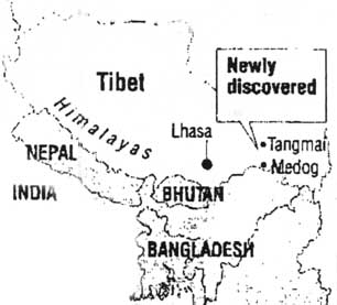
The following is an article that appeared in newspapers around the country, around January 8, 1999. It was sent to us by a reader: From The Chicago Tribune News Service EXPLORERS FIND ELUSIVE SHANGRI-LA IN WORLD'S DEEPEST KNOWN GORGE No record exists of people ever having seen the 100 foot-high waterfall and lush subtropical garden in the Tibetan Himalayas until now WASHINGTON - Explorers finally have found Shangri-La. It might not be quite the storied, verdant, Utopia Himalayan paradise of James Hilton's 1933 novel "Lost Horizon" and subsequent movie of the same name. But it is verdant, it is a kind of paradise, and it is hidden deep within Tibet's Himalayas in a monstrously steep gorge within a gorge. There is no record of any person having visited, or even seen, the area before. Tucked beneath a mountain spur at a sharp bend of the Tsangpo River Gorge, where the cliff sides are only 75 yards apart and cast perpetual shadows, the place failed to show up even on satellite surveillance photographs of the area. "If there is a Shangri-La , this is it," said Rebecca Martin, director of the National Geographic Society's Expeditions Board, which sponsored the trek. "This is a pretty startling discovery, especially in a time when many people are saying, "What's left to discover?" Tentatively named by the explorers the Hidden Falls of the Tsangpo and located in a forbidding region called Pemako that Tibetans consider highly sacred, the elusive site was reached by American explorers Ian Baker, Ken Storm Jr. and Brian Harvey late last year, though the society did not make its confirmation of their success official until Thursday. In addition to a spectacular 100-foot-high waterfall- long rumored but until now undocumented- they found a subtropical garden between a 23,000 foot and a 26,000 foot mountain, at the bottom of a 4,000 foot high cliff. According to Martin, it's the world' deepest mountain gorge. "It's a place teeming with life." Storm said in telephone interview from his office in the Minneapolis suburb of Burnsville. "It's a terribly wild river, with many small waterfalls, heavy rapids and a tremendous current surging through. Yet there are all kinds of flora; subtropical pine, rhododendrons, craggy fir and hemlock and spruce on the hillsides. It's lush. Just a tremendous wild garden landscape." The animals there include a rare, horned creature called the Takin, sacred to Tibetan Buddhists. Difficult as the gorge was to reach, Storm said one of the hardest aspects of the expedition was leaving to return to civilization. "The last we saw of it was looking down... with clouds sealing the gorge and side-stream waterfalls jetting out into the river," he said. "it's probably the most romantic landscape I'd ever seen." This was the seventh expedition that Baker, a Tibet scholar living in Katmandu, led into the Himalayas in search of the mythic falls. In addition to Storm, a book and game dealer turned explorer, and Harvey, a National Geographic photographer, the team included another scholar, Hamid Sardar of Cambridge, Mass., two Tibetan hunters, a Sherpa guide and eight porters - though Baker, Storm and Harvey were the only ones to make the demanding descent to the gorge and falls. Among other things, their discovery proves that two great rivers of Asia - the Tsangpo, which runs completely across Tibet, and the mighty Brahmaputra, which runs through the Indian state of Assam and Bangladesh to the Bay of Bengal--are connected. Reminiscent of the fabled "source of the Nile" that English explorers Richard Burton and John Spede raced each other to find in the middle of the 19th century--both making controversial claims to have found it first--the Tsangpo falls and gorge proved so far beyond explorers' reach that they were declared nonexistant. The southern approach up the Brahmaputra posed the most obstacles. "It's tremendously difficult terrain of jungles and insects and tigers," Storm said. "The lower gorge area was protected by Abhors and Mishmi, Burmese tribal groups. They protected that area pretty fiercely, and early British attempts to penetrate were frustrated." In 1911, two British explorers were able to locate all but 30 to 40 miles of the river connection. A local guide named Kintup was later hired to continue into the inner gorge and try to find the sacred place by traveling as a Buddhist pilgrim. He claimed to have found a connection between the two rivers but said the only high waterfall was not on the Tsangpo but up a smaller tributary. In 1924, British botanist Francis Kingdon-Ward advanced to a point that narrowed the unknown stretch of the river to three or four miles. He found a waterfall as well but measured it at only 30 feet. Finding further penetration impossible because of the steepness and narrowness of the gorge and bad weather, he turned back, declaring the long sought high falls nonexistent. Although the Tsangpo River starts at 7,000 feet above sea level, it rapidly descends and cuts through the Tibet plateau by way of the only gap in the Himalayas open to the heavy weather of the Indian plains and wetlands below. "The weather pours up from Assam, which is one of the wettest places on Earth, and you have notoriously terrible weather in there." Storm said. "You can go weeks if not months with clouds and rains and snow at the higher elevation. You have a river literally eating its way through these mountains in this great gorge." Lasting 17 days, Baker's expedition approached the Tsangpo from the north, following animal trails and the advice of their Tibetan hunters and descending some 4,000 feet. Using mountaineers' ropes to get down the last 80 feet of the cliff, they found themselves at the "great falls," which they measured with laser range finders - a Shangri-La just a quarter of a mile from where Kingdon-Ward turned back. "It's a powerful sight to experience," said Storm, who said he plans to return. "it's a rather humbling feeling just to have taken part." - END |
|
| Shangri-La: Filmmakers
and mountaineers assault a sacred mountain (Part I)
Shangri-La: Filmmakers and mountaineers assault a sacred mountain (Part II) Chinese government puts Shangri-la on the map (Part III) Shangri-La isn't what it was (Part IV) Konkaling - One Man's Shangri-la from Khamaid Foundation Explorers say
area discovered in Tibet is lush with life and
glorious waterfalls. "The Heart of the World: A Journey to the Secret Place" Book Review PDF Controversy Surrounded Hidden Falls
- Who
found
it First Hidden Waterfalls of Shangri-La
In Quest of Shangri-La - Interview with Ian Baker Tourism 1998 National Geographic Society-sponsored kayaking expedition of the Tsangpo River There was also an ill fated kayaking expedition that left one world class kayaker dead (Walker 1). Older Expeditions |
|
| McGowan, William. “Into the Heart
of the Lotus; When Ian Baker finally found the
legendary Hidden Falls at the bottom of the world’s
deepest gorge, was he really on the verge of paradise?
Or would he have to settle for fame and fortune?”
WashingtonPost.com. 6 June 1999
http://www.washingtonpost.com, 3 October 2001.
Below is a Free Preview of the Article from the
Washington Post Archives The Washington Post - Washington, D.C. In January the National Geographic Society announced that (Ian) Baker had led an expedition into a remote mountainous area of southeastern Tibet called Pemako-- "The Hidden Land of the Opening Lotus," as it is known in Tibetan. There he had discovered a long-rumored but never before documented major waterfall on Tibet's mighty Tsangpo River. Clawing their way down mist-cloaked, nearly sheer 4,000-foot cliffs into a rocky gorge-within-a-gorge so deep it remains in perpetual shadow and can't even be seen on satellite surveillance photographs, Baker and another team member were able to reach and measure a waterfall approximately 108 feet high, naming it Hidden Falls. "It's not just a place to go take pictures," Baker recalls the lama explaining. But once Baker conveyed his serious interest in the spirituality of the search, the lama told him to come back in the summer, and be prepared to spend a month alone in a cave. When Baker returned, the lama sent him off with two nomads who led him to a cave deep in a remote valley. But he hadn't abandoned his interest in the beyul tradition. The lama who'd sent him off to the cave told him beyuls were described in obscure, coded texts that dated from the 8th century. Eager to get his hands on some of them, Baker sought help from the Dalai Lama himself. In Dharmsala on academic business in 1987, he expressed his interest during an audience. Getting a "faraway" look in his eye, as Baker recalls it, the Dalai Lama directed a monk to help Baker locate a dusty tome from a high, dimly lit shelf in the Dharmsala library. This, like other similar texts, was, as Baker puts it, a kind of "Fodor's Guide to the fourth dimension," which advised pilgrims on how best to navigate landscapes that are invested with spiritual and mystical properties. Baker eventually expanded his collection of beyul texts to nine. |
|
|
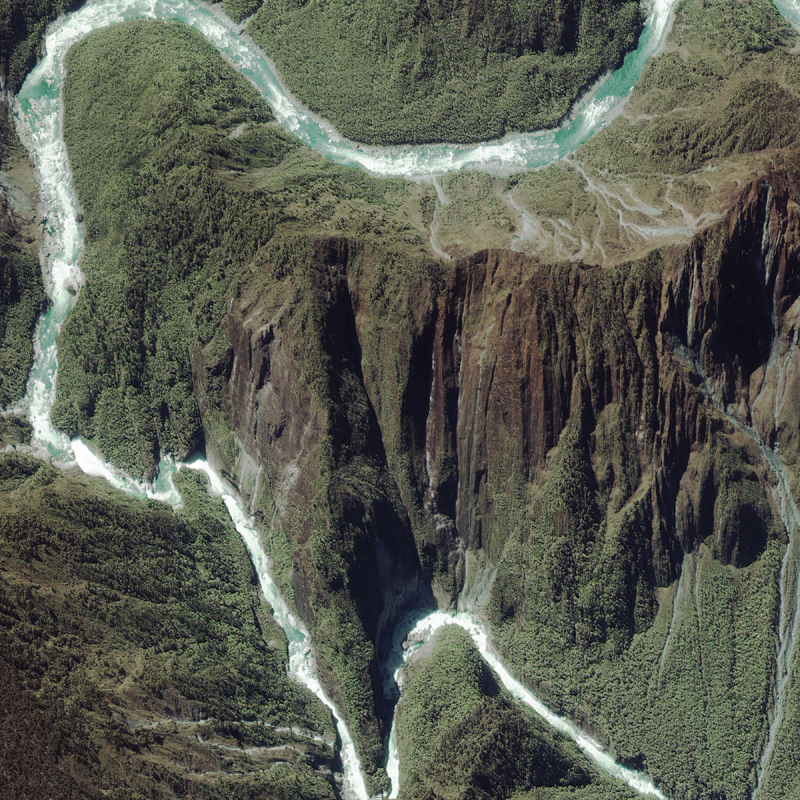
Space Imaging's IKONOS Satellite Images Prove Crucial for Tsangpo River Expedition in Tibet - Kayak Expedition Team Conquers One of the Last Great Adventures on Earth DENVER, May 23, 2002 - During a recent descent of Tibet's Tsangpo River by kayak, satellite images from Space Imaging's IKONOS satellite proved to be a crucial planning and mapping tool for the 87-man Outside Tsangpo Expedition Team. Sponsored by Outside Magazine and Chevrolet's Chevy Avalanche, a team of the world's best expeditionary kayakers joined forces to attempt the historic first descent of the Tsangpo Gorge. The Tsangpo River is the highest river and the deepest gorge in the world. The river is thought by many professional adventurers to contain the most feared whitewater on the planet. Space Imaging's IKONOS satellite took this 1-meter
color image of Rainbow Falls and Hidden Falls along the
Tsangpo River May 9, 2000.
Space
Imaging's IKONOS satellite took this 1-meter
color image of Rainbow Falls After a 1998 National Geographic Society-sponsored kayaking expedition of the Tsangpo River, Space Imaging took the world's first commercial high-resolution satellite images of the remote Tibetan river. That expedition was called off before completion because of the tragic whitewater death of a kayaker. Then, in the summer of 1999, Scott Lindgren, a 29-year old world-class kayaker and Emmy-award winning cameraman, started planning to take a team to descend the Tsangpo. He turned to Space Imaging for the IKONOS satellite images that were taken in May 2000. "The satellite images were an absolute key to the success of the expedition," said team leader Lindgren. "The images were like being in a helicopter above the water. They gave us a bird's-eye view of the entire river before we ever left the U.S. Some areas of the Tsangpo Gorge have never been seen by man, that is until IKONOS took these amazing pictures." Showing rapids, steep canyon walls, trails and mountain passes, the set of 20 images, valued at more than $48,000, was loaded into the team's laptop computers and viewed with ERDAS' ViewFinder software. The very accurate, high-resolution images allowed the team, by using GPS coordinates, to navigate along specific sections of the river and know in advance what lay ahead. The team developed entry and exit waypoints that were then programmed into GPS receivers to keep the team on course. Large image-maps, overlaid with latitude and longitude grids, were also printed out and laminated, and were used daily by both on- and off-river teams. "We spent days pouring over the satellite image-maps. They gave us a far stronger understanding of what we were to encounter than I ever expected. I can't imagine doing another expedition of this magnitude without satellite imagery," said Lindgren. The entire expedition, which started on Jan. 21, 2002, took more than a month to complete. Not only did they complete the first descent of the Tsangpo Gorge, but they were also only the third Western expedition ever to traverse the Gorge, the first two being done on foot - Frank Kingdon Ward in 1924 and Ken Storm, Jr.'s team in 1998. Lindgren and other team members filmed the historic trek for Outside Television Productions. The expedition TV special, "Into the Tsangpo Gorge," will air on NBC Sports this Sunday, May 26, at 2:30 p.m. ET. Outside Magazine's coverage of the expedition will be its cover story in the July issue and is currently featured on Outside Magazine's Web site at www.outsidemag.com. Also, Lindgren is scheduled to be interviewed on NBC's Today show on Friday, May 24. |
|
Kelsang
Metok - Falling Love with Jiuzhaigou Valley
YOUTUBE LINK |
|
| FAIR USE NOTICE: This page contains copyrighted material the use of which has not been specifically authorized by the copyright owner. Pegasus Research Consortium distributes this material without profit to those who have expressed a prior interest in receiving the included information for research and educational purposes. We believe this constitutes a fair use of any such copyrighted material as provided for in 17 U.S.C § 107. If you wish to use copyrighted material from this site for purposes of your own that go beyond fair use, you must obtain permission from the copyright owner. | |
|
|
