|
|
||
|
..
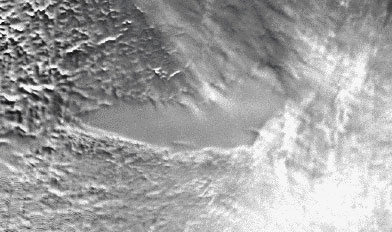
RADARSAT image of the surface of the Antarctic ice sheet above Lake Vostok. Credit: NASA Goddard Space Flight Center. July 8, 2004 WASHINGTON - Lake Vostok, deep beneath the Antarctic ice, appears to be divided into two deep basins, according to researchers who profiled the lake with an array of complex instruments. Photo: RADARSAT image of Lake Vostok (from NASA-GSFC). More than 70 lakes have been identified beneath the thick Antarctic ice sheet from ice-penetrating radar (Siegert et al., 1996). Most of these lakes, captured between 3-4 kilometers of ice, are several kilometers long and are primarily located beneath the major ice divides. One of these lakes, Lake Vostok, is an order of magnitude larger than others. This lake is a large system and represents the closest analogue to Europa the ice covered Jovian moon and to a Neoproterozoic subglacial environment. Lake Vostok was identified in 1996 by Russian and British scientists (Kapitsa et al., 1996) who integrated data ranging from down-hole seismics, star observations and airborne ice-penetrating radar to new spaceborne altimetric observations. The horizontal extent of the lake is estimated from the flat surface (0.01 degrees) observed in the ERS-1 ice surface altimetry. The 4-kilometer-thick ice sheet goes afloat as it crosses the lake, just as ice sheets become floating ice shelves at the grounding line. The subglacial environment represents one of the most oligotrophic environments on Earth, an environment with low nutrient levels and low standing stocks of viable organisms. If life thrives in the environments it may have to depend on alternative energy sources and survival strategies.
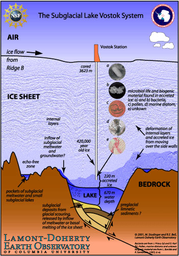
Hidden beneath some two miles of ice, Lake Vostok is a liquid body of water roughly the size of Lake Ontario. It is thought to have existed undisturbed for thousands of years and researchers hope to sample the lake for signs of microbes. A longtime Russian research station at the lake site has produced measurements of the lake bottom at various points. But the new analysis is the first overall water depth map of the lake. Researchers from the Lamont-Doherty Earth Observatory of Columbia University and the University of Tokyo reported their findings in a recent issue of Geophysical Research Letters. Michael Studinger of Lamont-Doherty said that the existence of two distinct regions with a ridge between them could have significant implications for what sorts of ecosystems scientists would find in the lake. "The ridge between the two basins will limit water exchange between the two systems. Consequently, the chemical and biological composition of these two ecosystems is likely to be different," he said in a statement released Wednesday. The team used a laser altimeter, ice-penetrating radar and gravity measurements collected by aircraft flying over the lake to produce their analysis. They found two distinct sub-basins separated by a narrow ridge. The water over that ridge is about 650 feet deep, compared to roughly 1,300 feet deep in the northern basin and 2,600 feet deep in the southern. The U.S. National Science Foundation supported the research. SOURCE: Yahoo News |
||
| FAIR USE NOTICE: This page contains copyrighted material the use of which has not been specifically authorized by the copyright owner. Pegasus Research Consortium distributes this material without profit to those who have expressed a prior interest in receiving the included information for research and educational purposes. We believe this constitutes a fair use of any such copyrighted material as provided for in 17 U.S.C § 107. If you wish to use copyrighted material from this site for purposes of your own that go beyond fair use, you must obtain permission from the copyright owner. | ||
|
|