|
|
|||||
|
..
4 December 2009
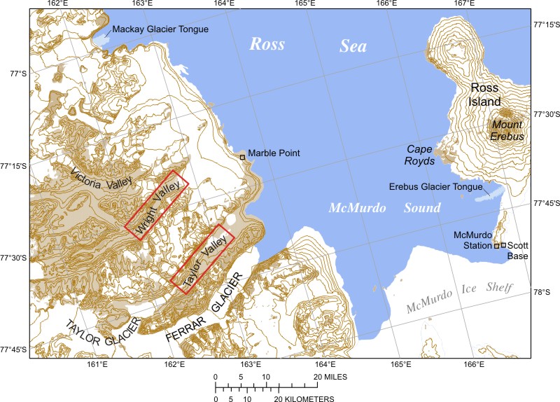
The McMurdo Dry Valleys are a row of valleys west of McMurdo Sound, Antarctica, so named because of their extremely low humidity and lack of snow and ice cover. Photosynthetic bacteria have been found living in the relatively moist interior of rocks. Scientists consider the Dry Valleys to be the closest of any terrestrial environment to Mars. With its 14 spectral bands from the visible to the thermal infrared wavelength region and its high spatial resolution of about 50 to 300 feet, ASTER images Earth to map and monitor the changing surface of our planet. ASTER is one of five Earth-observing instruments launched Dec. 18, 1999, on NASA's Terra satellite. The instrument was built by Japan's Ministry of Economy, Trade and Industry. A joint U.S./Japan science team is responsible for validation and calibration of the instrument and the data products. The broad spectral coverage and high spectral resolution of ASTER provides scientists with critical information for surface mapping and monitoring of dynamic conditions and temporal change. SOURCE: NASA |
|||||
|
..
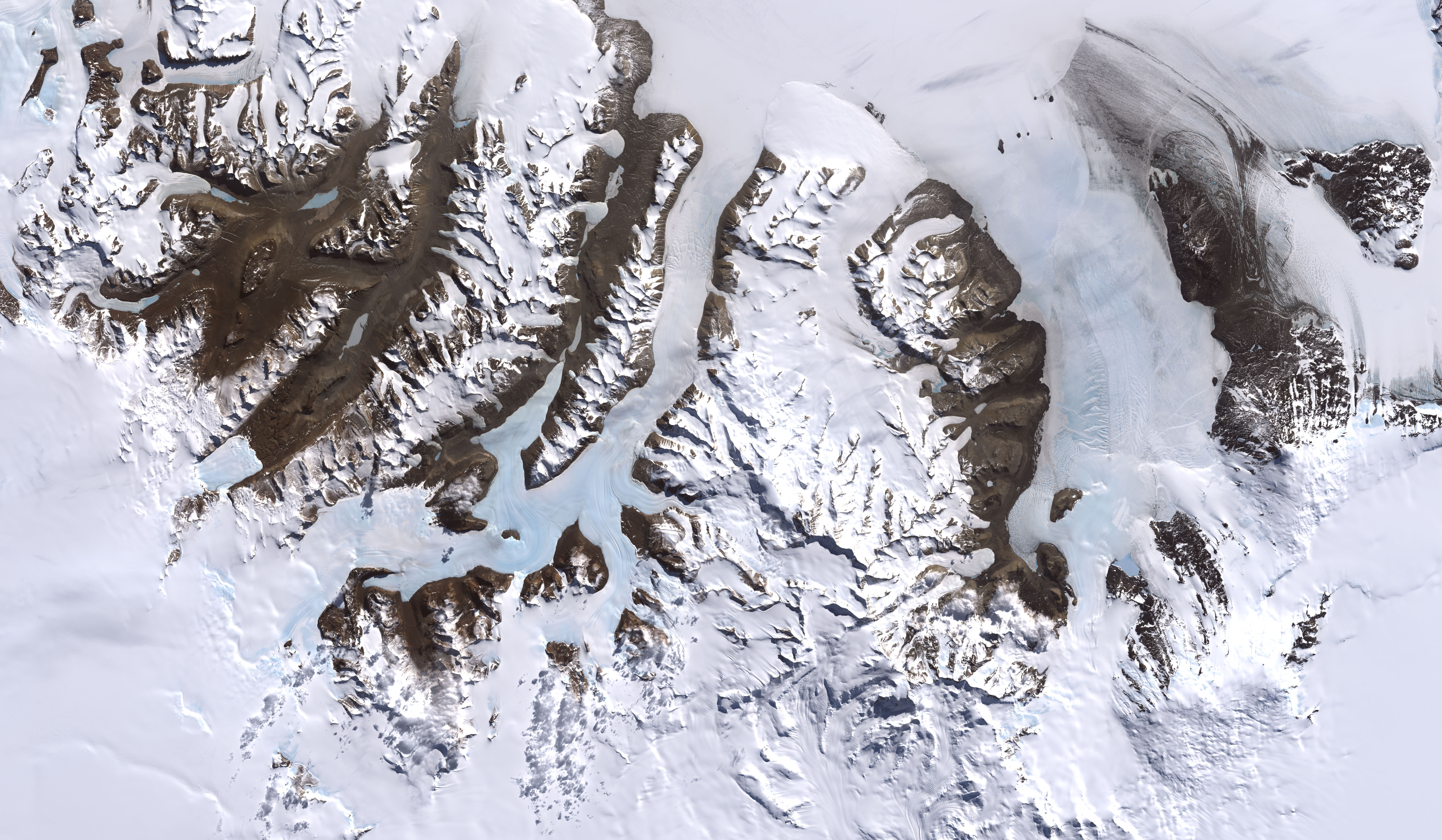
The McMurdo Dry Valleys are a row of valleys in Antarctica located within Victoria Land west of McMurdo Sound.[1] The region is one of the world's most extreme deserts, and includes many interesting features including Lake Vida and the Onyx River, Antarctica's longest river.
This image was acquired by Landsat 7s Enhanced Thematic Mapper plus (ETM+) instrument on December 18, 1999. Credit: Image by Robert Simmon, based on data provided by the NASA GSFC Oceans and Ice Branch and the Landsat 7 Science Team One of the few areas of Antarctica not covered by thousands of meters of ice, the McMurdo Dry Valleys stand out in this satellite image. For a few weeks each summer temperatures are warm enough to melt glacial ice, creating streams that feed freshwater lakes that lie at the bottom of the valleys. Beneath a cap of ice these lakes remains unfrozen year-round, supporting colonies of bacteria and phytoplankton. Over the past 14 years, however, summers have been colder than usual, and the lakes are becoming more and more frozen. If the trend continues, the biological communities they support may go into hibernation. Most of Antarctica has cooled along with the Dry Valleys, in contrast to much of the rest of the Earth, which has warmed over the past 100 years. No one knows if the trend is related to global climate, or just a quirk in the weather. Climate The unique conditions in the Dry Valleys are caused, in part, by katabatic winds: these occur when cold, dense air is pulled downhill by the force of gravity. The winds can reach speeds of 320 km/h (200 mph), evaporating all water, ice and snow.[3] Geology Biota
Unusual bacteria have been found in Blood Falls at the tongue of the Taylor Glacier, above the ice-covered surface of Lake Bonney in Taylor Valley.
The image is a scan of my old print. The image was taken by Mila Zinkova Mummified seal carcass
Part of the Valleys was designated an environmentally protected area in 2004. Major geographic features Valleys
Some of the lakes of the Dry Valleys rank among the world's most saline lakes, with a higher salinity than Lake Assal (Djibouti) or the Dead Sea. The most saline of all is small Don Juan Pond.
|
|||||
|
References
|
|||||
| The Dry Valleys of Antarctica
Pictures © 1977 Thierry Cappelle
and © 1996 Billy, Laura Connor and Effie Jarret; used with permission.
"Sure, the lion is king of the jungle, but airdrop him into Antarctica, and he's just a penguin's bitch." Dennis Miller.On this page:
Images by Billy, Laura Connor and Effie Jarret The dry valleys are strange: except for a few steep rocks they are the only continental part of Antarctica devoid of ice. Located in the Trans-Antarctic Range, they correspond to a mountain area where evaporation (or rather, sublimation) is more important than snowfall, thus all the ice disappears, leaving dry barren land.
Here a glacier coming from the continental ice field flows down the valley and just dries out. In summer there can be rivers in the Dry Valleys. Moss and some other form of vegetation grow. Some lakes have strange characteristics, like lake Vanda, always covered with ice, but with salt-saturated liquid water underneath and very mysterious biology. Mummified bodies of seals have been found in those parts, hundreds of kilometers from the sea.
The Dry Valleys are a favorite
exploration spot for geologists and microbiologists. I've never been there,
those pictures were taken by Laura Connor and Effie Jarret who flew over
them several times during their remote sensing missions.
Images by Thierry Cappelle
..
Height of the ice: 30 to 50 meters. ..
If you want more info on the Dry Valleys, there's an excellent site. SOURCE: The Dry Valleys of Antarctica |
|||||
| FAIR USE NOTICE: This page contains copyrighted material the use of which has not been specifically authorized by the copyright owner. Pegasus Research Consortium distributes this material without profit to those who have expressed a prior interest in receiving the included information for research and educational purposes. We believe this constitutes a fair use of any such copyrighted material as provided for in 17 U.S.C § 107. If you wish to use copyrighted material from this site for purposes of your own that go beyond fair use, you must obtain permission from the copyright owner. | |||||
|
|


![[DryValleyFrontGlacier.jpg]Disappearing glacier in the Dry Valleys, Antarctica](../04images/Antarctica/DryValleyFrontGlacier.jpg)
![[DryValleyIceFall.jpg]Sublimating ice in the Dry Valleys, Antarctica.](../04images/Antarctica/DryValleyIceFall.jpg)
![[Cappelle100.jpg]Return flight from Dome C to McMurdo above the Dry valleys.](../04images/Antarctica/Cappelle100.jpg)
![[Cappelle101.jpg]In the Dry Valleys: glacial tongue coming down from the inlandsis towards the bottom of the valley. Height of the ice: 30 to 50 meters.](../04images/Antarctica/Cappelle101.jpg)
![[Cappelle102.jpg]Another glacial tongue coming down from the inlandsis towards the bottom of the valley. About 50 meters high.](../04images/Antarctica/Cappelle102.jpg)