|
|
||
|
..
02-November
1999
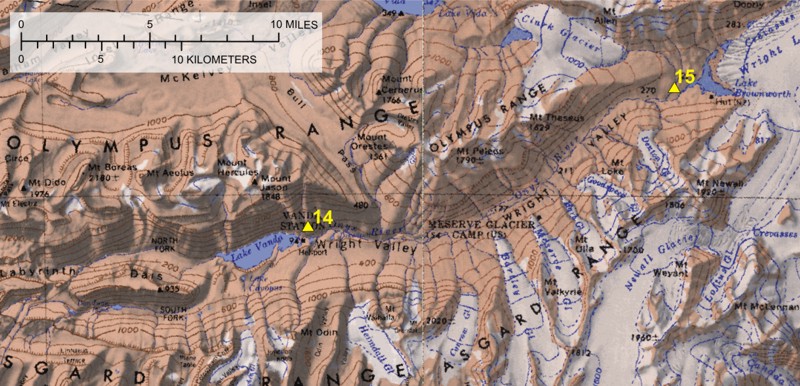
Greetings all...I am back at Lake Hoare, my home away from home again after spending a couple of days back in McMurdo. Nice to be back in the valley, since it is such a wonderful spot. On Saturday I was treated to the full grandeur the valleys have to offer. I had to fly with a couple other folks around to 8 of the meteorological stations. We went to the 5 stations in the morning, stopping for about 20 minutes at each station. The weather was perfect, with temperatures around +5F, which made for some spectacular views of the valley. Flying by helicopter makes it so much easier, plus it provides some magnificent views along the way. In the afternoon we went north to the other three stations, which are located to the north. We flew up over the Asgard Range and dropped back down to the Wright Valley, stopping at Lake Vanda. The picture I have attached is from Lake Vanda, looking to the west over the lake. You can see the meteorological stations, plus the helicopter and the frozen lake. After checking the stations we all walked out on to the ice and peered into the frozen world below. In places the ice was some clear we could not tell if it was ice or water. The only clue that it was ice was tiny little bubbles that were located near the bottom. From Lake Vanda, we cruised to Lake Vida and Brownsworth. The wind at Vida and Vanda was very light, which made it feel like a tropical paradise. The wonderful day was ended with a nice dinner of chicken stew back at Lake Hoare.
The data I
download from the data will be used to try to understand the processes
occurring in the valley and how they affect the glacier. The data consist
of air, soil and ice temperatures, relative humidity, incoming and outgoing
solar radiation, wind speed, wind direction and a host of other parameters.
Data are collected every 15 minutes for the entire year. Besides the science
it is interesting in finding out how cold or windy it gets here in the
winter. The maximum wind speed recorded for the year in the valleys, which
was measured at 85 mph on the Canada Glacier, occurred less than three
weeks ago. The particular event is called a katabatic. Winds come whipping
down the valley, blowing sand and dust in its path. It can also blow over
tents, which happen to the four people who were in camp at the time. The
lowest temperature of occurred at Lake Vida. Today was one to relax and
catch up on my personal life. I haven't had a chance to organize my stuff,
especially my tent, since I arrived. My tent, which is to the right in
the second attached photo, is located on Glacier Heights. I have an incredible
view of the Canada Glacier, which is almost spitting distance from my door.
After my restless first night I have slept wonderfully in my peaceful environment.
No cars, busses, doors, music etc to wake me from my dreams. The only sound
was the wind blowing down the valley. This morning was again glorious,
but unfortunately the clouds sauntered their way across the sun. Only the
second day in two weeks that the sun has been covered by clouds. Since
the weather did not deter us from barbecuing Mahi Mahi on the outside grill.
On Sunday the camp manager has the day off, so the beakers, which is what
the scientists are known down here, get to cook. Cooking on the outside
grill just added to the parody this life down here has to offer. Of coarse
I had to whip up one of my grandmother's apple pies to top off the pipes.
Umm, umm good... This week I will start making measurements on the glaciers.
Tomorrow, if the weather is alright, I, accompanied with a guide from McMurdo,
will head up to the upper part of the Taylor Glacier. There I will measure
the distance from various bamboo stakes, which are drilled into the ice,
to the ice surface. The purpose is to determine the change in the surface
of the glacier over time. These gives an indication of the effect climate
has on the glacier. By the end of the week I will have visited the other
five glaciers, Canada, Commonwealth, Howard, Suess and Hughes. I am hoping
my luck with the weather holds.
That is the news from the Dry Valleys, where the winds are strong and the temperatures are brisk. Sincerely, Thomas SOURCE: http://www.glaciers.pdx.edu/Projects/Antarctica/Antarctic2000/1999-11-02.html |
||
|
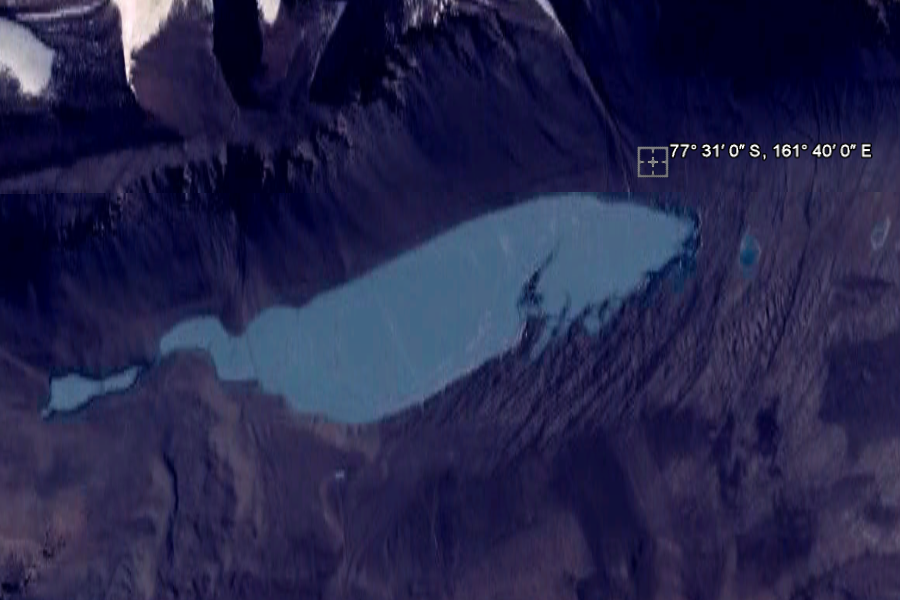
77° 31′ 0″ S, 161° 40′ 0″ E ..
Lake Vanda Lake Vanda is a lake in Wright Valley, Victoria Land, Ross Dependency, Antarctica. The lake is 5 km long and has a maximum depth of 69 m.[1] On its shore, New Zealand maintained Vanda Station from 1968 to 1995. Lake Vanda is a hypersaline lake with a salinity more than ten times that of seawater,[2] more than the salinity of the Dead Sea, and perhaps even more than of Lake Assal (Djibouti), which is the world's most saline lake outside of Antarctica. Lake Vanda is also meromictic, which means that the deeper waters of the lake don't mix with the shallower waters.[3] It is only one of the many saline lakes in the ice-free valleys of the Transantarctic Mountains. The largest river of Antarctica, Onyx River, flows West, inland, into Lake Vanda. There is a meteorological station at the mouth of the river. While no species of fish live in Lake Vanda or the Onyx River, microscopic life such as algal blooms have been recorded.
Lake Vanda Station was well known for The Royal Lake Vanda Swim Club.[4] Visitors to Lake Vanda Station could dip into the high salinity waters when the icecap edge melted out during summer to form a 'moat', and receive a Royal Lake Vanda Swim Club shoulder patch. Vanda staff would assist the melt by hacking out a 'pool'. Many dignitaries and politicians were inducted into the club, The dip had to be naked (Rule 1), complete immersion (Rule 4), witnessed by a 'Vandal' (Vanda Station staffer) and with no restrictions on photography (Rule 6) to qualify. Rule 10 allowed a natural figleaf, but it had to be natural and also naturally green without artificial aid.
Vanda Station was removed in 1995 as lake levels rose, and is replaced by a shelter, Lake Vanda Hut, that is periodically staffed by 2-8 stream researchers.[5] References
|
||
| FAIR USE NOTICE: This page contains copyrighted material the use of which has not been specifically authorized by the copyright owner. Pegasus Research Consortium distributes this material without profit to those who have expressed a prior interest in receiving the included information for research and educational purposes. We believe this constitutes a fair use of any such copyrighted material as provided for in 17 U.S.C § 107. If you wish to use copyrighted material from this site for purposes of your own that go beyond fair use, you must obtain permission from the copyright owner. | ||
|
|