NEWS RELEASESFOR IMMEDIATE RELEASE
Feb. 21, 2007 Sandia searches for unexploded
ordnance

Imagery of old Kirtland bombing site. Further analysis
of the LiDAR data found two more targets located in areas of highest crater
density.
A complete site survey was conducted at the old Kirtland bombing range near Double Eagle Airport on Albuquerques west mesa recently by a team from Sandia National Laboratories and Pacific Northwest National Laboratory (PNNL). The survey was part of an expansion of the Eclipse Aviation facility near Double Eagle Airport for installation of water and power lines. The survey of the Kirtland site, one of the national Wide Area Assessment (WAA) sites, was initiated and funded by the Department of Defenses Strategic Environmental Research and Development Program (SERDP) and the Environmental Security Technology Certification Program (ESTCP). The survey showed no evidence of any target areas south of the runways. This southern portion of the site completely encompasses the area in which Eclipse Aviation is expanding, so good news for them, says Sean McKenna, Sandia project team leader. We did identify several other potential target areas north of the airport; some of these turned out to be geological noise such as magnetic rocks. About three of them turned out to be legitimate potential ordnance target areas. The team used LiDAR (light detection and ranging) imagery to remotely characterize the Kirtland site and the imagery revealed several features indicative of UXO targets. The LiDAR provided a high-resolution topographic map of the area and focused on old targets such as concentric circles, a ship outline, and other areas of interest, McKenna says. Sandia is a National Nuclear Security Administration
(NNSA) laboratory.
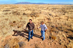 Sandia researchers Sean McKenna and Barry Roberts check
data that confirms the location of metal fragments associated with the
old Kirtland bombing range on Albuquerques West Side.
These geophysical tools dont have the discrimination power to identify UXO versus scrap metal, but they do a good job of identifying locations with relatively larger concentrations of metal in the ground, says McKenna. Typically, these areas are the target locations were interested in. Research on the development of the project techniques was funded by SERDP beginning in 2000. Work funded by SERDP focuses on basic research. The ESTCP subsequently funds initial field application and verification of technologies developed under SERDP funding. Sandia received ESTCP funds for initial field testing, which involved application of algorithms to simulated sites; no field sites had been adequately characterized and excavated to a point where they could be used for validation. Results on the simulated sites were successful. ESTCP recently organized a set of wide-area technology assessments and demonstrations. These wide-area studies involved the testing and evaluation of a number of UXO technologies at a given field site. The field sites for the wide-area assessment have been chosen based on visibility and urgency of the need to remediate the land. Urgency is generally driven by someone else wanting to use the land. Sandia has been involved with various WAA research
sites including the Pueblo site in southeast Colorado; Toussaint River,
an underwater site in Lake Erie off the north shore of Ohio; the Victorville
site in Southern California; and the Camp Beale site north of Sacramento,
Calif.
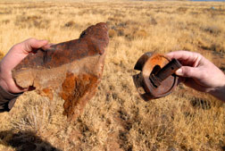 Download 300dpi JPEG image, uxo-bombparts.jpg, 724K (Media are welcome to download/publish this image with related news stories.)
Overall, as much as 20,000,000 acres of land in the US thats about half the size of Maine could possibly contain UXO. The unexploded ordnance is left over from wars as well as from decades of live-fire training and practice in the US. UXO presents a discrete and acute health hazard, but not the same as the land-mine problem, says Barry Roberts, a member of the team. The Kirtland site was used for training during and after WWII. In addition, data collected from known historic target sites at Laguna and Iselta pueblos have been used for development of various research techniques. The data sets, funded by SERDP, were mainly collected to test the helicopter-mounted magnetometer being built by Oak Ridge National Laboratory.We also used the data for the statistical algorithm development work, but did not complete any reports regarding the two sites, McKenna says. Currently the team is writing final reports for the Pueblo, Victorville, and Kirtland sites. The Sandia team has completed work on the conceptual model for Camp Beale and worked with the Corps of Engineers and PNNL to come up with a transect design for that site. The ground magnetometer surveys will begin there this month. This year, ESTCP has funded Sandia to develop a training
course with PNNL to present to state and federal regulators and contractors
involved with site characterization and cleanup using these methods. The
first course will be offered in August.
Sandia is a multiprogram laboratory operated by Sandia Corporation, a Lockheed Martin company, for the U.S. Department of Energys National Nuclear Security Administration. Sandia has major R&D responsibilities in national security, energy and environmental technologies, and economic competitiveness. Sandia news media contact: Michael Padilla, mjpadil@sandia.gov,
(505) 284-5325
|
| FAIR USE NOTICE: This page contains copyrighted material the use of which has not been specifically authorized by the copyright owner. Pegasus Research Consortium distributes this material without profit to those who have expressed a prior interest in receiving the included information for research and educational purposes. We believe this constitutes a fair use of any such copyrighted material as provided for in 17 U.S.C § 107. If you wish to use copyrighted material from this site for purposes of your own that go beyond fair use, you must obtain permission from the copyright owner. |
|
|