|
Secrets of the Great Pyramids |
|||||||||||
Posted by Just-Think on August 13, 2009 at ATS Post ID 6905318 Zorgon, did you ever read that .pdf file I've send u a while ago ? This is exactly what is was about including the scans... Since the completion of the survey, and the report, the Polish team has asked for permission to excavate at the Gizeh plateau in those areas where the ground scans have revealed cavities. So far, these proposals have been rejected. Maybe you will find these interesting as well, same people think they have found the Hall of Records in the Labyrinth in Hawara... Geophysical
Studies
of Hawara Pyramid Area - Faiyum - National
Research Institute
of Astronomy and Geophysics prepared by
Geomagnetism and Geoelectricity
Dept. - April 2008
|
|||||||||||
|
..
NRIAG Journal of Geophysics, Special Issue, PP. 1 ? 16, (2006) National
Research Institute of
Astronomy and Geophysics, Helwan, Cairo, Egypt
ABSTRACT: The Pyramids-Giza plateau still has
a universe of unrevealed
secrets. The eons passed since the building of the
Pyramids, makes this
area unique. These huge structures reflect the
passion and the discipline
of the old Egyptians. The size and effort involved,
makes one question:
Is that all? Is there still more hidden and
In the present work, the GPR technique has been applied to selected areas over the Pyramids plateau. As most of the previous work done in this area was so shallow, the present work has been planned using a multi-frequency antenna with a chosen frequency of 16 MHz . This frequency allows for greater depth penetration and therefore, the possibility of locating any possible deeper targets. The following interpretations of the collected GPR profiles show some interesting features which are probably a location for archaeological relics in two areas:
INTRODUCTION The possibility of hidden archaeological remains at the Pyramids plateau of Giza has never been dismissed or discounted. Wide groups of archaeologists, Egyptologist and scientists still believe in the probability of new discoveries under the sands. This possibility can be made fact by applying the powerful geophysical GPR approach. Early in 1975 Bevan and Kenyon were
raising the use
of GPR for historical archaeology. Then, in 1977,
Kenyon discussed the
prospect to apply the GPR survey on historical
archaeological site. Later,
the GPR measurements became an essential tool in
archaeological inspection.
Heimmer and De Vore (1995), Goodman (1994), Clark
(1996), Lawrence and
Goodman (1997) have utilized the GPR technique in
archaeological studies.
On the Pyramids plateau the geophysical techniques
have been applied on
many occasions. A study carried out by Yoshimura and
Tonauchi (1987) using
the, GPR and gravimetery were designed to answer
three questions: the inner
structure of the Cheop's Pyramid, the constitution
of the Sphinx and to
determine the age/era during which the Sphinx was
carved. Another geophysical
work had been done by Dobecki and Schoch (1992).
They conducted seismic
surveys including seismic refraction tomography and
high resolution reflection.
The purpose of this investigation is to analyze the
depth and distribution
of weathering in the exposed limestone bedrock, to
search for voids and
cavities around and under the Sphinx and to describe
the bedrock configuration
buried by
Abbas (1998) studied the best way
for the restoration
of the Sphinx and its protection against the
groundwater invasion. Using
geophysical survey, Mesbah (2005) studied from a
geotechnical point of
view whether the Pyramids plateau was a good option
to set up such huge
structures. In our present study, the GPR have been
anticipated to be employed
as a means to investigate deep-wide parts of the
plateau to reveal any
hidden
The studied areas are distributed over the Pyramids plateau to ensure coverage of selected key zones. The results of the survey support the possibility of the presence of undisclosed relics, of high value. IDEA The worldwide
interest in the
Pyramids area is well known. Some people still
believe in the power of
the Pharaohs and their mysteries. The authors have
pursued this universal
interest. The opinions of specialist
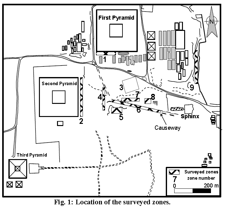
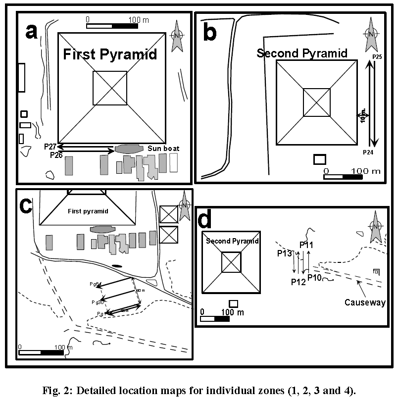
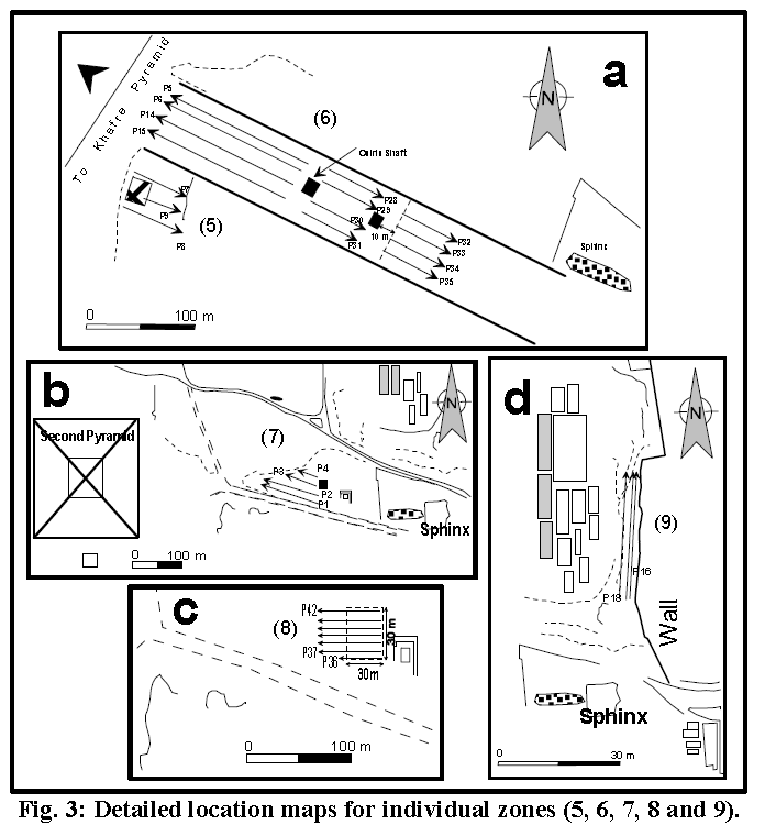
THE SURVEY OF THE SELECTED ZONES Archaeologists accompanying our team during the exploration excursion guide us to where the possibility of finding new exploration was most likely based on their experience and background. A total of nine surveyed zones have been distributed along the Pyramids plateau (Fig. 1). In zone (1) which is to the southern side of Khufu Pyramid (Fig. 1), two parallel profiles 2 m apart were done (P26 and P27) . The two profiles are both 115 m long. Profile P26 measured from west to east, while P27 measured from east to west (Fig. 2a). Zone (2) is placed to the eastern side of Khafre Pyramid (Fig.1). The two profiles P24 and P25 are 210 m long. Profile P24 carried out from east to west while, Profile P25 was carried out from west to east. The Profile P25 is 10 m apart from the Khafre Pyramids? base. The profile P25 is 2 m apart from profile P24. The presence of an existing excavation determined our plan to perform a detailed study at zone (3). In this zone which lies between the first Pyramid and the causeway, a grid of 60x60 m has been surveyed with 1 m offset between the profiles (Fig. 2d).
Between the eastern side of the second Pyramid and the causeway, four profiles (P10-P13) have been conducted in zone 4 from south to the east direction (Fig. 2c). To the south of the causeway, zone 5 has been surveyed (Fig. 1). In this zone three profiles from northwest to southeast direction have been done (Fig. 3a). Zone (6) has been applied along the causeway (Fig.1). Because of the length of the causeway, the profiles have done on different stages. The first stage (Fig. 3a), four profiles (P5-P6, P14-P15) have been surveyed from east to west direct along the causeway. In the second stage, four profiles (P29-P31) have been conducted from west to east direction. After 10 m from the end of the profiles of the second stage, the third stage has begun with its four profiles (P32-P35) from west to east direction (Fig. 3a) To the north of the causeway, zone 7 begins with its profiles (Fig. 1). In this zone, four profiles (P1-P3) have been carried out from southeast to northwest direction (Fig. 3b). For zone (8), 7 GPR profiles have been conducted (Fig. 3c). In zone 9, three parallel profiles (P16-P18) have been applied from south to north direction (Fig. 3d)
|
|||||||||||
| DATA PROCESSING
AND ANALYSIS
We have used some simple processing steps to visualize the radar profiles and to get rid of the interference of the embedded high frequency noise during the survey. The processing protocols used are : background removal, band pass frequency, gain enhancement and time to depth conversion. For the conversion of time to depth we need the velocity of the wave propagation. It is well-known that the Pyramids plateau is formed entirely of dolomitic limestone of the Mokattam Formation (Salem, 1976). To determine the optimum velocity that can yield precise depth, we tried different means. After Landau-Boernstein, (1982); Davis and Annan, (1989); and Guéguen and Palciauskas, (1994) the relevant properties of some common near-surface earth materials have been studied to select the optimum relative dielectric value. The relative dielectric constant of the limestone varies between 4 and 8. Whereas, the dielectric constant of the dolomite has a range between 6.8 and 7.8 (Lawrence and Goodman, 1997). These values could be higher given the presence of water and clay contents. Furthermore, Fisher et al. (1992) described the following criterion for finding the best possible velocity for a migration algorithm. For the correct migration velocity, the migrated image will be well focused. If the chosen migration velocity is too low, diffraction hyperbolas will not collapse completely but certain hyperbolic tails will remain in the image. A too large
velocity results
in diffraction tails that
extend from
a diffractor towards
shallower depths. This
approach of testing
different migration velocities
mimics that employed when migration trials are
used
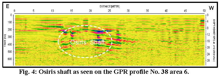
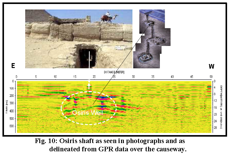
The previously mentioned procedures have been applied to trace the range of dielectric constant and propagation velocity which could impact the studied areas. At the end, the propagation velocity estimate for the GPR profile was conducted over the Osiris well (Fig. 4). The depth of the well has been measured and time-depth conversion has been calculated using different velocities. The best derived velocity value is 0.08. This velocity has been used to convert the measured GPR profiles in the studied area.
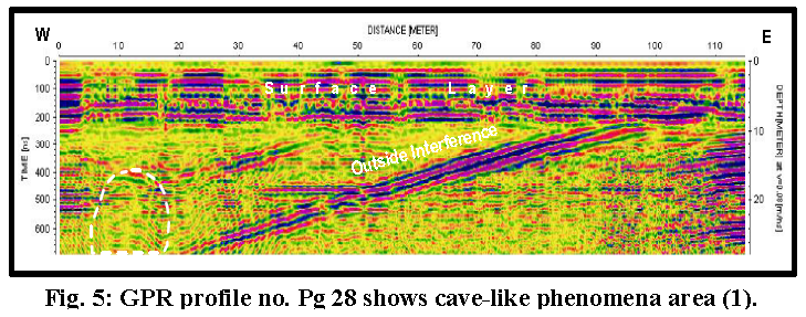
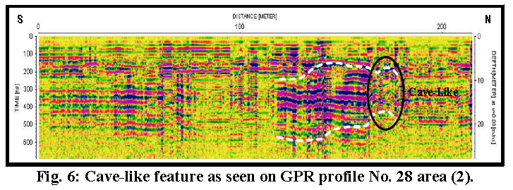
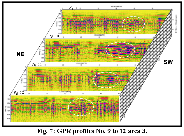
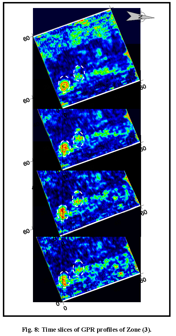
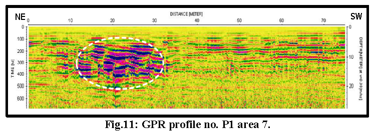
A number of interesting features have been delineated through out the plateau. These features could be of archaeological significance. Also, the common criteria of them are its fairly deep location. The velocity that used to turn the time-depth conversion has yield a total depth of 28 m. The defined features are rest starting from 8 m depth. For zone (1), Figure (5) is a GPR profile measured from west to east. It shows a hyperbola at 17 m. depth. Also, some outside interference of direct wave (sharp straight-tilted lines) is easily perceived. In Figure (6), for a GPR profile conducted at zone (2) another hyperbolic feature has been delineated. To the southern side of this hyperbola a rather conductive zone of lateral extension about 25 m has been outlined. Both hyperbolas of zone (1) and (2) are described as of a cave-like appearance. For zone (3), we have summarized some features that detected in this area in figure (7). A continuous appearance of a moderately conductive zone has been identified along the parallel GPR profiles. This appearance could be attributed to a shaft filled with conductive materials like clays or sandy clays. Two regions with that appearance have been outlined using the time slices for the whole set of data as seen in figure (8).
For
area (5),
no remarkable feature is
noted.For area
(6), over the causeway, only the
Osiris shaft was perceptible.
Figure (10) illustrates the shaft as it has been
revealed on GPR profile
P-38. No other features have
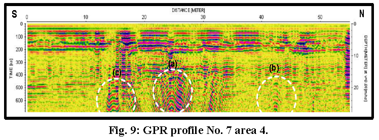
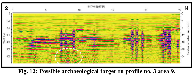
Also, area (8) has not shown any occurrence for any feature. And last, figure (12) belongs to GPR profile of area (9) which displays the presence of cave-like feature at depth 20 m.
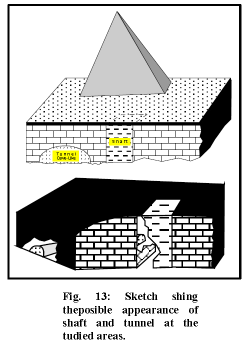
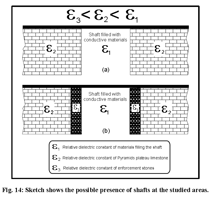
filled up with materials; it is like a void in the limestone rock; for example, see the feature which is marked on figures (5, 9 and 12). For the shaft, if it is just a cut in the limestone rocks (Fig. 14a), which has been filled up with conductive materials (clays or sandy clays), this filling material will reflect conductive zoon on GPR profiles. For example, the features marked on fig. (11). While, if the shaft walls were enforced by blocks of limestone (Fig. 14b) which could be of harder properties (reduced conductivity) than the surrounding rocks and dispersion in the radar energy due to the blocks edges could be caused. So, a possible two hyperbolas at both sides of the shaft might be anticipated; as seen in Fig.(9). Given
the preceding
illustration and assertion, we
can presume
the existence of a
momentous diversity of
archaeological structures at the
Pyramids plateau which
remain, as yet, unexposed. These structures
could
RESULTS AND COMMENTS
The entire area needs more geophysical work from different directions to strengthen the present result. The amount of work done to date is not a sufficient basis on which to form a definitive judgment on the delineated phenomena. These phenomena raise a massive number of questions for the scientific researcher. We hope to answer these questions after further study. ACKNOWLEDGMENTS The authors express their gratitude to the Supreme Council of Antiquities and to Dr. Zahi Hawwas who permitted the conduction of the present work in supportive surroundings SOURCE:
|
|||||||||||
|
Ground-penetrating radar exploration for ancient monuments at the Valley of Mummies -Kilo 6, Bahariya Oasis, Egypt
Fathy A. Shaabana, Abbas M. Abbas, Magdy A. Atyaa and Mahfouz A. Hafeza National Research Institute of Astronomy and Geophysics, 11421 Helwan, Egypt Received 6 October 2007;
Abstract A Valley of Mummies was discovered recently by an Egyptian team at Bahariya Oasis, located about 380 km west of the pyramids. Four tombs were excavated, and inside them were found one hundred and five mummies (105), many of them beautifully gilded. These mummies, many sumptuously decorated with religious scenes, are the very best Roman-Period mummies ever found in Egypt. These remains are around 2000 years old, but they are in remarkable condition. A Ground-Penetrating Radar (GPR) had proved successful in detecting the cavities in resistive soil in which the mummies were found. The GPR survey conducted near the earlier-discovered tombs at Kilo-6 El-Bahariya to Farafra Oasis road is the focus of this paper. The GPR survey was conducted using the SIR-2000 attached to a 200 MHz monostatic antenna. The two areas to be surveyed were selected by the archaeologists in situ. Area one was 40 m × 40 m and Area two was 30 m × 15 m. A grid pattern survey in one direction; with one-meter profile spacing was done to both areas. In addition, a focusing survey was undertaken over the entire Area one. In addition, twenty long GPR profiles were conducted in an attempt to determine the outer, expected limits of the burial area. After the data acquisition, Reflex software was used for data processing and presentation. The final results of the radar survey: in the form of 2D radar records, time slices and 3D block diagrams; were used to guide the archaeologists during the excavation process. The excavation processes have been completed by the archaeologists, and many tombs and mummies were discovered. It is worthy to mention that, the excavations and location of tombs and cavities matched strongly with the GPR results. Ground-penetrating
radar
exploration for ancient monuments at the Valley of
Mummies
|
|||||||||||
| FAIR USE NOTICE: This page contains copyrighted material the use of which has not been specifically authorized by the copyright owner. Pegasus Research Consortium distributes this material without profit to those who have expressed a prior interest in receiving the included information for research and educational purposes. We believe this constitutes a fair use of any such copyrighted material as provided for in 17 U.S.C § 107. If you wish to use copyrighted material from this site for purposes of your own that go beyond fair use, you must obtain permission from the copyright owner. | |||||||||||
|
|