|
|
|||||
|
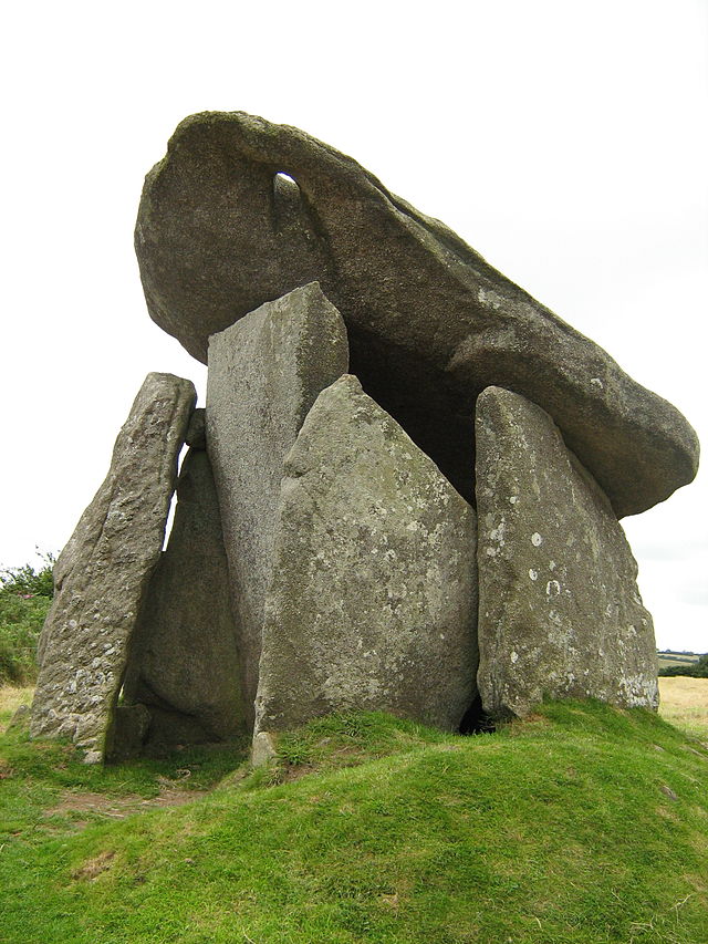
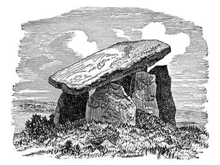
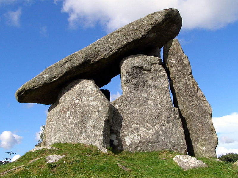
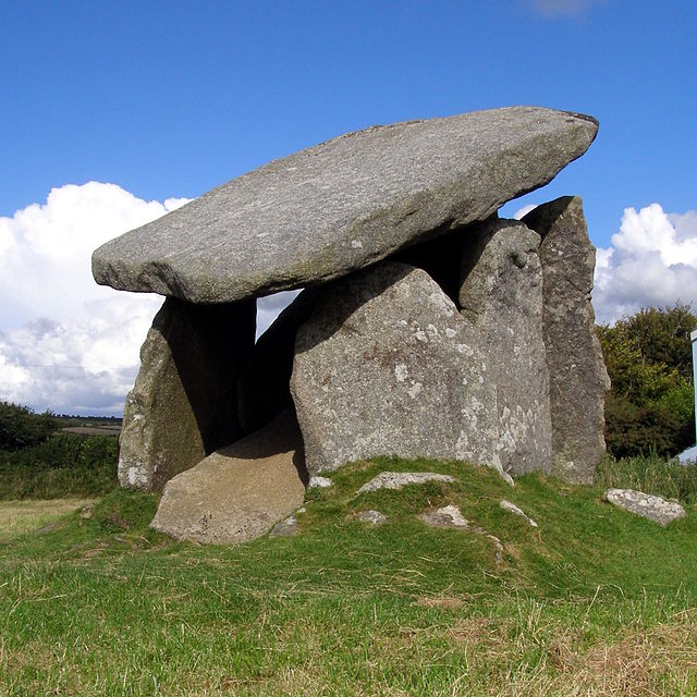
Bodmin Moor Dolmens Trethevy Quoit near St Cleer, Cornwall 50° 29′ 35.41″ N, 4° 27′ 19.4″ W ..
The quoit is made up of seven slabs with a huge sloping capstone estimated to weigh 10.5 tons alone Jun 2006 © All Rights Reserved
Trethevy Quoit (Cornish: Koyt Tredhewi) is a well-preserved megalithic tomb that lies between St Cleer and Darite in Cornwall, England, United Kingdom. It is known locally as "the giant's house". Standing 9 feet (2.7 m) high, it consists of five standing stones capped by a large slab. Location Trethevy Quoit is north of Liskeard in the hamlet of Tremar Coombe. Trethevy farmhouse is a Grade II* listed building. Nearby are The Hurlers, three stone circles dating from the late Bronze Age. The site is managed by the Cornwall Heritage Trust on behalf of English Heritage.
Construction
Like other portal tombs of this type, Trethevy Quoit was originally covered by a mound. The remnants of this suggest a diameter of 6.5 metres. The remaining seven stones and the 3.7 m long and 10.5-ton cover slab were inside the mound. At the upper end of the cover slab is a natural hole, which may have been used for astronomical observation. The group of horizontal stones is composed of a fallen back wall, two side wall stones, which overlap, a front stone and a somewhat remote flanking stone. The special feature of Cornish portal graves is that by such stones sometimes a smaller partially closed area is created before the front end. Some stones have hole-like perforations as decoration. The front stone is often called an entrance stone, although in most portal graves this can not be moved. The Trevethy Quoit is a rare exception here, because a small rectangular stone moving at the bottom right of the front allows access to the grave chamber, which is now opened only very rarely. The back of the chamber has collapsed inwards and now forms a pile inside the chamber. Erected this stone would be about the height of the front stone, so that the cover slab would not have once been held-up by the side stones, but rested almost horizontal solely on the front stone and rear walls. However, there would have been between the support stones and the side walls a considerable gap, by which soil could have penetrated into the grave chamber. It is therefore likely that the collapse of the rear wall and the falling-down of the cover slab damaged the side stones.
East
side of Trethevy Quoit
Studies
Trethevy Quoit was first mentioned in 1584 by John Norden, in a topographical and historical account of Britain, but this account was first published in 1728. In the 19th century William Copeland Borlase studied the site and made drawings of it. From this study came the first conjectures on the overturned back wall and the earlier appearance of quoit. Hencken in 1932 wrote the first modern interpretation, in which he explained the special nature of the antechamber, and pointed out parallels to structures in Brittany. Recent excavations showed that this type of megalith was erected in the Neolithic period between 3700-3500 BC and such megaliths were used over a long period of time as community graves.
South
side of Trethevy Quoit
|
|||||
|
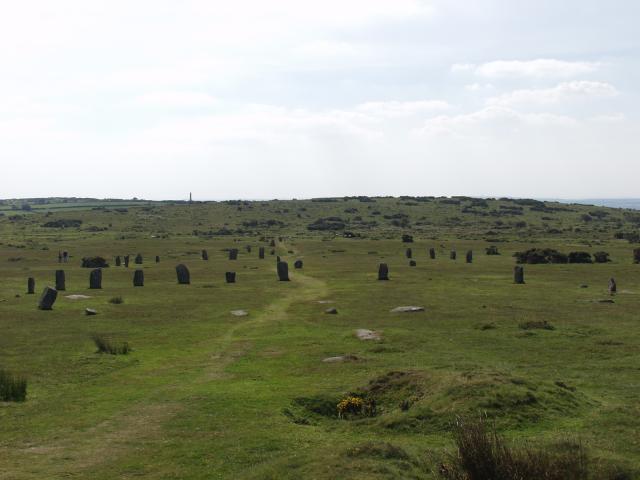
Bodmin Moor The Hurlers (stone circles) near Minions, Cornwall 50° 30′ 51.12″ N, 4° 27′ 16.92″ W ..
Standing stones in the middle circle
of The Hurlers
Jim Champion (treehouse1977)
The Hurlers from the north. Alan
Simkins - Geograph project
The Hurlers (Cornish: An Hurlysi) is a group of three stone circles in Cornwall, England. The site is half-a-mile (0.8 km) west of the village of Minions on the eastern flank of Bodmin Moor, and approximately four miles (6 km) north of Liskeard at grid reference SX 258 714. Location The Hurlers are in the Caradon district north of Liskeard near the village of Minions on the southern edge of Bodmin Moor in Cornwall. Just to the west of the circles are two standing stones known as the Pipers. Nearby are Rillaton Barrow and Trethevy Quoit, an entrance grave from the Neolithic period. The Hurlers are managed by the Cornwall Heritage Trust on behalf of English Heritage. Construction The Hurlers comprises three stone circles that lie on a line from SSW to NNE, and have diameters of 35 metres (115 ft), 42 metres (138 ft) and 33 metres (108 ft). The two outer stone circles are circular. The middle circle, the largest is slightly elliptical. The survival of the southern stone circle, which now contains nine stones, has been most precarious: only two of the remaining stones are upright and the other seven are partially covered with soil. In the middle circle 14 stones survive out of 28. The stones show clear traces of being hammered smooth. The northern stone circle contained around 30 standing stones, from which 15 are still visible. Two other monoliths, the Pipers, are 100 metres (330 ft) southwest of the middle circle and may be entrance stones to the Hurlers.
The north circle. Brudersohn
The Hurlers - Stone Circle - Liskeard, Cornwall, UK Early accounts The earliest mention of the Hurlers was by historian John Norden, who visited them around 1584. They were described by William Camden in his Britannia of 1586. In 1754 William Borlase published the first detailed description of the site. Excavations C. A. Ralegh-Radford excavated the site in the 1930s, and partly restored the two northern circles by re-erecting some stones and placing marker stones in the positions of those missing.[10][11] Archives from the unpublished excavation reports have been re-evaluated by Jacky Nowakowski (Cornwall Heritage Trust) and John Gould (English Heritage) and may result in more analysis and publication.
There have been several subsequent investigations. Between 1975-1985 aerial survey and subsequent analysis by various teams, (including Cambridge University, University College London, RCHME and co-ordinated by Cornwall Archaeology Unit) was used to identify and map the features. English Heritage conducted a geophysical survey in 2004. A survey by the Cornwall Archeological Unit in 2009 indicated that there might also be a fourth circle and two stone rows. The Hurlers was scheduled as an ancient monument in 1981, and the protected area was extended in 1994 to include the Pipers, Alignments Alexander Thom suggested borderline case alignments at the Hurlers. He suggested two solar alignments of four stones with far uprights. He suggested two stone-to-site alignments with Vega and Arcturus and two other site-to-site alignments with Arcturus. Each stellar alignment was given with tabulated declinations at a date some time in between the range of 2100 to 1500 BC. |
|||||
|
Bodmin Moor The Pipers near Minions, Cornwall 50° 30′ 55.8″ N, 4° 27′ 35.64″ W ..
Jim Champion 6 August 2007
The Pipers -
standing stones near the Hurlers This is a pair
of standing stones, not far to the west of the
Hurlers stone circles on Craddock Moor. The name
of this pair of stones is associated with the
usual petrification folklore relating to stone
circles - these are a pair of pipers turned to
stone for playing on the Sabbath, presumably
accompanying the Hurlers in their game of
hurling.Looking to the north, directly between the stones, you see Stowe's Hill - site of a neolithic enclosure and the natural rock formation of the Cheesewring. The right hand side of the hill is scarred by the Cheesewring granite quarry. The dung in the foreground was left by one of the ponies that graze the open moorland. The Pipers are a pair of
standing stones near The Hurlers stone circles,
located on Bodmin Moor near the village of Minions,
Cornwall, UK. They share the name with another pair
of standing stones near the Merry Maidens to the
south of the village of St Buryan, also in Cornwall.
Description The Pipers are approximately 2 metres high and the width between them is about the same distance. They are situated about 120 metres west-south-west of the central Hurlers circle. According to folklore they represent musicians playing for three circles of dancers who were turned to stone for engaging in festivities on a holy day. The area around the Pipers is notable in archaeology for the discovery of a bronze dagger and gold beaker along with some beads and flint at Rillaton Barrow in 1818, approximately 550 m north of the Pipers. |
|||||
|
Bodmin Moor Rillaton Barrow near Minions, Cornwall 50° 30′ 55.8″ N, 4° 27′ 35.64″ W ..
Foster, Eric (21 December 2008)
The Rillaton Barrow, an ancient
burial mound on Bodmin Moor, close to the
village of Minions in South East Cornwall.
Rillaton barrow (Cornish: Krug
Reslegh) is a Bronze Age round barrow in Cornwall,
United Kingdom. The site is on the eastern flank of
Bodmin Moor in the parish of Linkinhorne about four
miles (6 km) north of Liskeard.
Rillaton barrow was excavated in 1837 and found to contain a centrally-placed inhumation beneath the 25m wide barrow. The burial had been placed in a stone cist measuring 2m by almost 1m. Human remains were found along with grave goods including the Rillaton Gold Cup, a bronze dagger, beads, pottery, glass and other items. The Rillaton Gold Cup
Rillaton
Gold Cup - Material:
Gold
Created Early Bronze Age, perhaps c. 1700 BC Discovered - Rillaton, Cornwall, Present location - British Museum Most notably, the burial contained the Rillaton Gold Cup, a biconical gold vessel, 90mm high, with a handle attached with rivets. The cup resembles a late Neolithic (approx 2300 BC) ceramic beaker with corded decoration and was until 2007 thought to date to a much later period of c. 1650-1400 BC. In 2001 the similar Ringlemere Cup was found which has a similar corded style termed grooved ware, though it was (and remains) crushed nearly flat. Subsequent theories that it might have been deposited as a votive offering have now been abandoned in favour of it being part of the original grave goods in the Ringlemere barrow. It has been suggested that the cup shows an Aegean style and resembles similar finds from the Greek site of Mycenae, suggesting cultural and trading links with the Eastern Mediterranean. The Rillaton Cup and the Pelynt Dagger are two artefacts that have been found in Cornwall that have been claimed to show contact with the Mycenaean world. However the most recent study by Stuart Needham and others sees no reason to look so far afield for parallels, and locates them in a group with other "unstable" cups (round-bottomed and unable to stand up) in precious materials found in north-western Europe. They propose a date around 1700 BC for the Rillaton Cup, though it may have been buried a long time after it was made. After their discovery in 1837 the finds were sent as Duchy Treasure trove to William IV, and remained in the royal household. Used by King George V in his dressing room as a receptacle for his collar studs, after his death in 1936 the importance of the cup and associated dagger came to be appreciated, leading to their loan to the British Museum, where it remains on show next to the similar Ringlemere Cup, though still belonging to the Royal Collection. The other objects found with the cup have now disappeared, and "no useful descriptions or depictions are known"; they might well have helped assess the date. An exact copy may be seen in the Royal Cornwall Museum at Truro. In 2007 there have been calls in the local Cornish press for the Rillaton Gold Cup, along with the Morvah Gold Hoard and Towednack Gold Hoard to be returned to Cornwall from the British Museum. A legend associated with the cup is that Rillaton is haunted by the spirit of a druid priest, who offers travellers a drink from an undrainable cup. One night a traveller threw the cup's contents at the ghost, and was later found dead in a ravine. |
|||||
|
Bodmin Moor The Merry Maidens near St Buryan, Cornwall 50° 3′ 54.14″ N, 5° 35′ 23.03″ W ..
Jim Champion 13 August 2005
The Merry
Maidens stone circle in West Penwith, Cornwall.
Contrast selectively improved using filters in
Gimp 2.0The Merry Maidens (grid
reference SW432245), also known as Dawn's Men (a
likely corruption of the Cornish Dans Maen "Stone
Dance") is a late neolithic stone circle located 2
miles (3 km) to the south of the village of St
Buryan, in Cornwall, United Kingdom. A pair of
standing stones, The Pipers is associated both
geographically and in legend.
Description The circle, which is thought to be complete, comprises nineteen granite megaliths and is situated in a field alongside the B3315 between Newlyn and Land's End. The stones are approximately 1.2 metres high, with the tallest standing 1.4 metres. They are spaced three to four metres apart with a larger gap between the stones on the east side. The circle is approximately twenty-four metres in diameter. To the south is another stone which suggests a possible north-south orientation. In earlier times there was another stone circle located 200 metres away but this had been destroyed by the end of the 19th Century. 300 metres to the northeast are The Pipers – two 3-metre high standing-stones. These have been described as "largest surviving standing stones in Cornwall and probably the best known". The Tregiffian Burial Chamber is nearby. Myth and legend The local myth about the creation of the stones suggests that nineteen maidens were turned into stone as punishment for dancing on a Sunday. (Dans Maen translates as Stone Dance.) The Pipers, two megaliths some distance north-east of the circle, are said to be the petrified remains of the musicians who played for the dancers. A more detailed story explains why the Pipers are so far from the Maidens – apparently the two pipers heard the church clock in St Buryan strike midnight, realised they were breaking the sabbath, and started to run up the hill away from the maidens who carried on dancing without accompaniment. These petrifaction legends are often associated with stone circles, and is reflected in the folk names of some of the nearby sites, for example, the Tregeseal Dancing Stones, the Nine Maidens of Boskednan, as well as the more distant Hurlers and Pipers on Bodmin Moor. Another tradition says that The Pipers were erected to commemorate Howel and Aethelstan, leaders who died in a 10th-century battle.
The Merry Maidens
Research
The Merry Maidens were first examined in detail by antiquarian William Borlase in 1769, who also reported a second equally large circle of stones. In 1872 William Copeland Borlase, a descendent of the elder Borlase, produced a more detailed description of the area. At that time seven stones were still present from the second stone circle, before it disappeared by the end of the 19th Century. Hugh O’Neill Hencken wrote a first modern scientific view of the archaeological site in 1932. A more recent study was produced by John Barnatt in 1982. Today it is thought that there were originally 18 standing-stones. In the mid-19th century new stones were added in an attempt at reconstruction, but not in the correct position or number. In addition, some of the old stones were moved, giving the appearance that the stone circle has today.
The
Merry Maidens engraved by W. & G. Cooke
1804
|
|||||
| FAIR USE NOTICE: This page contains copyrighted material the use of which has not been specifically authorized by the copyright owner. Pegasus Research Consortium distributes this material without profit to those who have expressed a prior interest in receiving the included information for research and educational purposes. We believe this constitutes a fair use of any such copyrighted material as provided for in 17 U.S.C § 107. If you wish to use copyrighted material from this site for purposes of your own that go beyond fair use, you must obtain permission from the copyright owner. | |||||
|
|