|
The Enigmas on Mars 48 |
||
|
Spirit PIA07829 ....
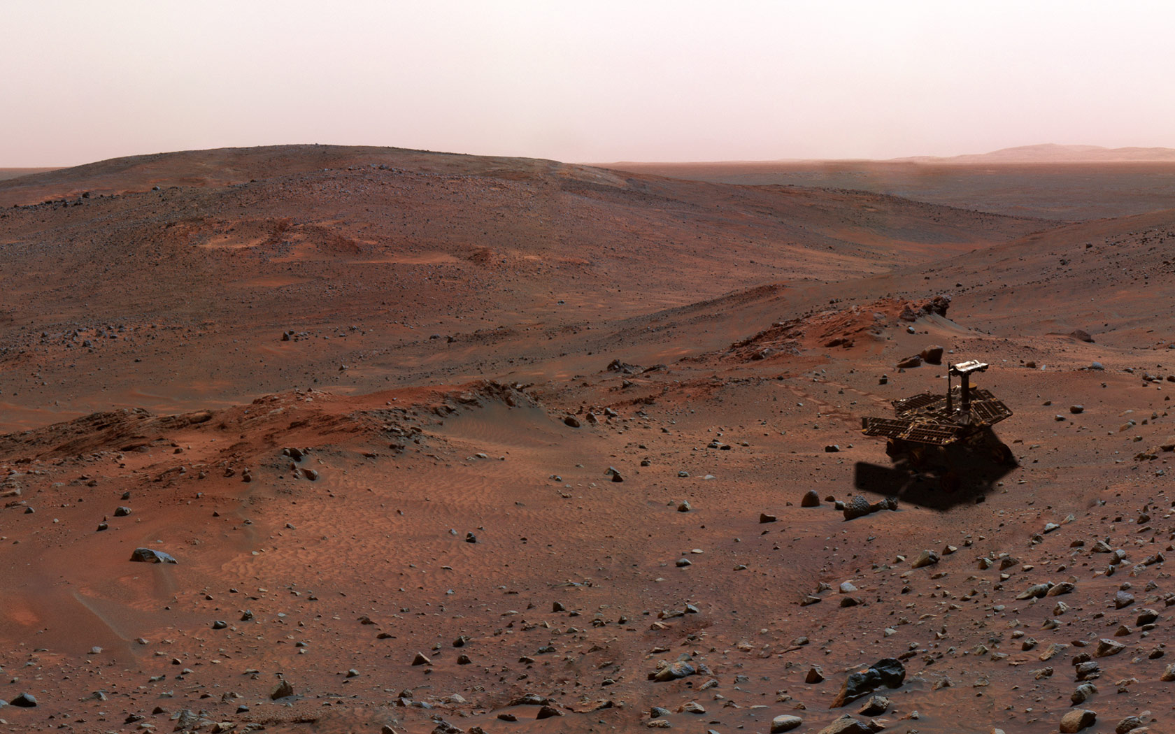
FULL SIZE Special-Effects Spirit in "Columbia Hills" This synthetic image of the Spirit Mars Exploration Rover in the "Columbia Hills" was produced using "Virtual Presence in Space" technology. Developed at NASA's Jet Propulsion Laboratory, Pasadena, Calif., this technology combines visualization and image-processing tools with Hollywood-style special effects. The image was created using a photorealistic model of the rover and an image taken by the Spirit navigation camera during the rover's 438th Martian day, or sol ( March 27, 2005); see PIA07829. The size of the rover in the image is approximately correct and was based on the size of the rover tracks in the navigation-camera image. Because this synthesis provides viewers with a sense of their own "virtual presence" (as if they were there themselves), such views can be useful to mission teams in planning exploration by enhancing perspective and a sense of scale. Image Note: Rover model by Dan Maas; synthetic image by Koji Kuramura, Zareh Gorjian, Mike Stetson and Eric M. De Jong. Credit: NASA/JPL-Caltech |
||
|
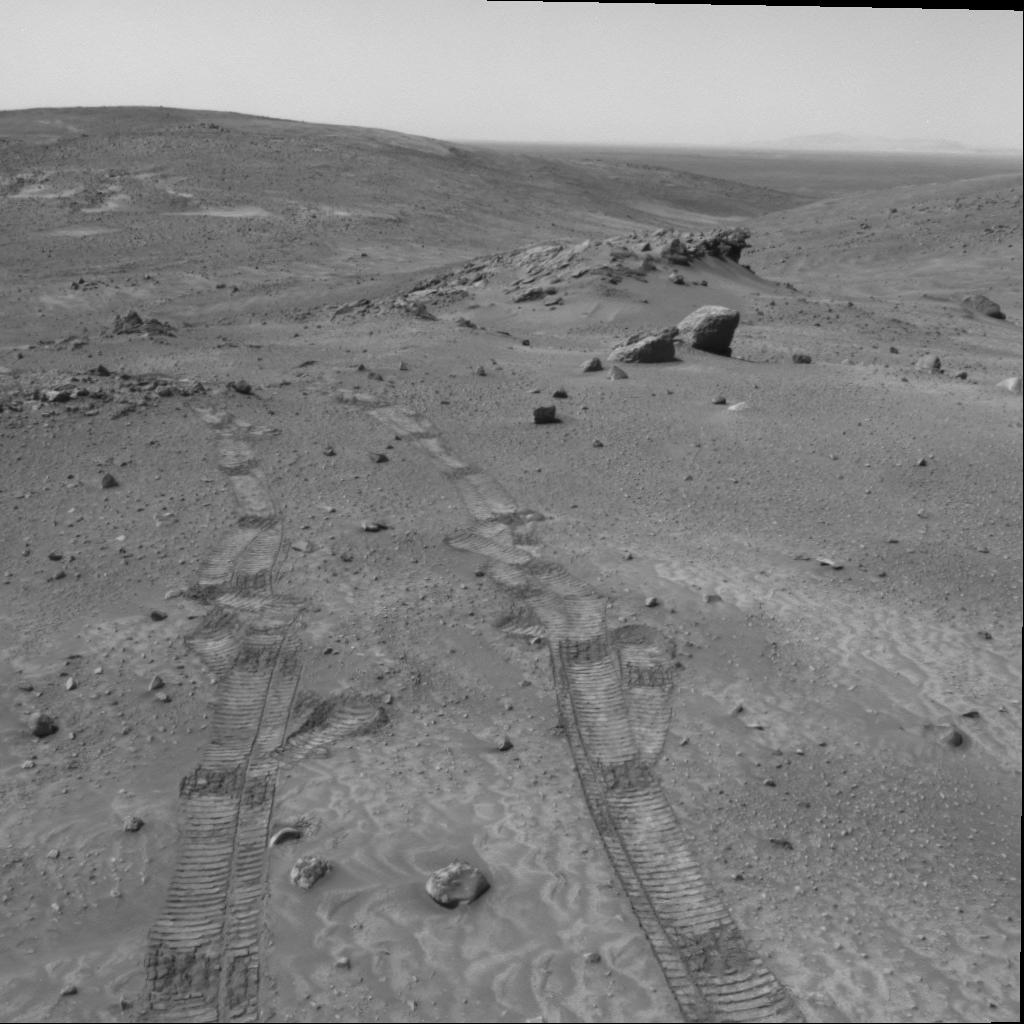
Spirit :: PIA07829 :: Sol 438 ....
FULL SIZE TIFF Original Caption Released with Image: Gazing across the landscape of the "Columbia Hills" in Gusev Crater on Mars, scientists working with NASA's Mars Exploration Rover Spirit think they have been seeing hints of tilted rock layers across the area traversed by the rover. At "Larry's Lookout," pictured here, ridges of rock are stacked atop each other and tilted. Similar rock ridges are visible in the distance across the "Tennessee Valley." One possible explanation for these ridges is that they were formed by tilted layers of sediment that were more resistant to erosion and now stand in relief above the surrounding surface. Scientists hope to better understand the structure of the hills and perhaps determine how they were formed by observing how the orientation of layers in these outcrops changes throughout the region. Hypotheses include that the Columbia Hills are the remains of an ancient volcano, a remnant of an old impact crater formed by an asteroid or comet, or delta deposits formed where water flowed into Gusev Crater early in its history. Each of these hypotheses leads to a different prediction regarding bedding orientation and structure. Hills on the distant horizon may be the rim of a large impact crater many miles to the east of the Columbia Hills. Spirit took this image with its navigation camera on martian day, or sol, 438 (March 27, 2005). Credit: NASA/JPL |
||
|
Next Stop: 'Methuselah' Spirit PIA70855 .''
FULL SIZE (25 megs) Special-Effects Spirit on Flank of "Husband Hill" This synthetic image of the Spirit Mars Exploration Rover on the flank of "Husband Hill" was produced using "Virtual Presence in Space" technology. Developed at NASA's Jet Propulsion Laboratory, Pasadena, Calif., this technology combines visualization and image-processing tools with Hollywood-style special effects. The image was created using a photorealistic model of the rover and a false-color mosaic. The size of the rover in the image is approximately correct and was based on the size of the rover tracks in the mosaic. The mosaic was assembled from frames taken by the panoramic camera on the rover's 454th Martian day, or sol (April 13, 2005); see PIA07855. Because this synthesis provides viewers with a sense of their own "virtual presence" (as if they were there themselves), such views can be useful to mission teams in planning exploration by enhancing perspective and a sense of scale. Image note: Rover model by Dan Maas; synthetic image by Koji Kuramura, Zareh Gorjian, Mike Stetson and Eric M. De Jong. Credit: NASA/JPL-Caltech/Cornell |
||
|
Spirit :: PIA 70855 :: Sol 454 .''
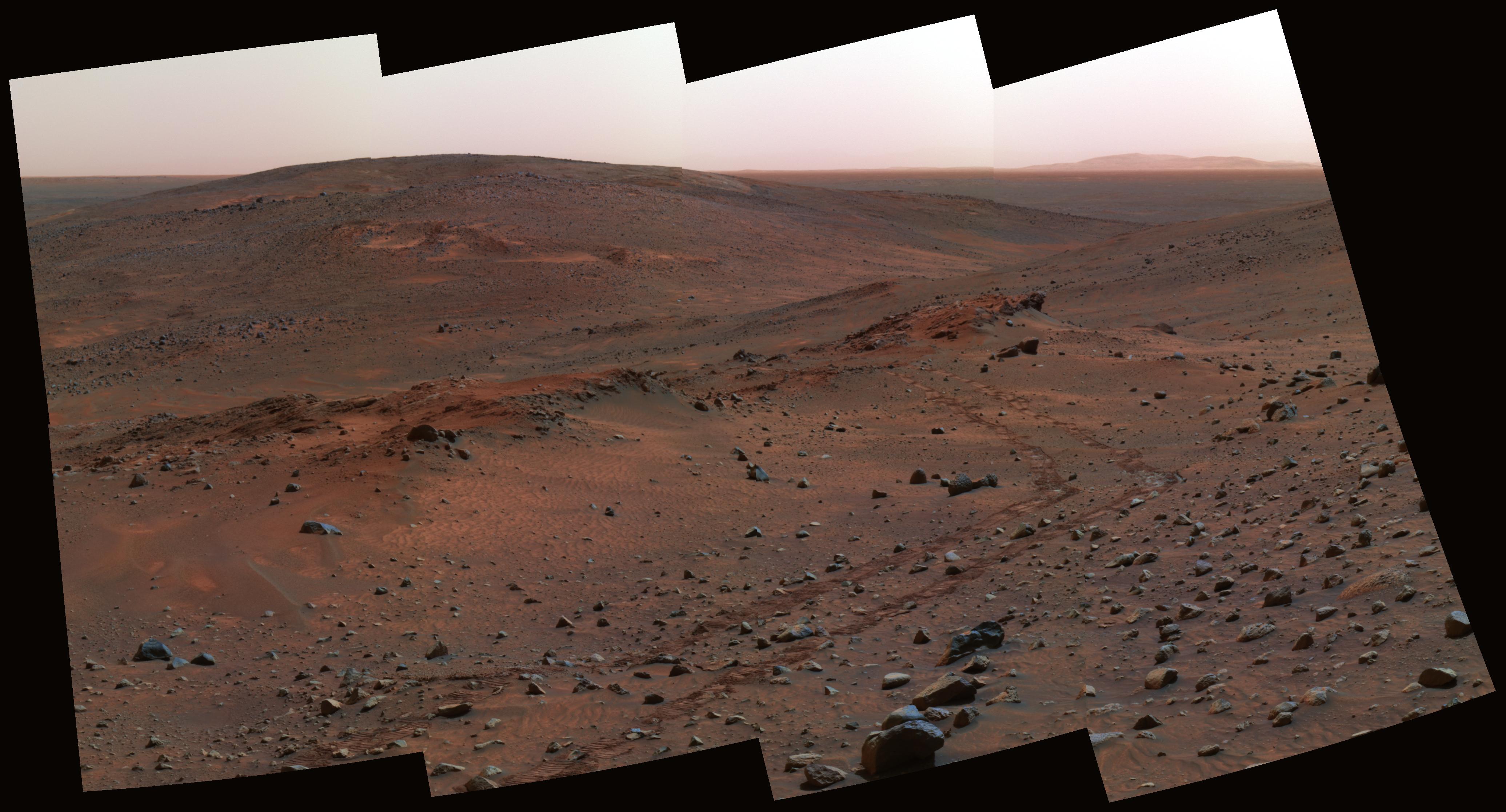
Full Version TIFF Original Caption Released with Image: NASA's Mars Exploration Rover Spirit is approaching an outcrop dubbed "Methuselah," which scientists intend for the rover to examine in detail for several days before resuming an uphill climb. This false-color view is assembled from frames taken by Spirit's panoramic camera on the rover's 454th martian day, or sol (April 13, 2005). It shows a region in the "Columbia Hills" slightly downhill from the rover. The view features two interesting outcrops in the middle distance and "Clark Hill" in the left background. The outcrop on the right, with rover tracks leading from it, is "Larry's Lookout." On the left is the Methuselah outcrop, with apparent layering. This view combines images taken through the camera's 750-nanometer, 530-nanometer and 430-nanometer filters. Credit: NASA/JPL
Image Credit: NASA/JPL/Cornell Updated Caption: Spirit Territory in Hills Three outcrops near each other on the flank of "Husband Hill" inside Gusev Crater are labeled on this false-color view assembled from frames taken by the Mars Exploration Rover Spirit's panoramic camera on the rover's 454th martian day, or sol (April 13, 2005). Credit: NASA/JPL |
||
|
Spirit Silhouetted on "Jibsheet" Spirit PIA07997 ....
FULL SIZE Special-Effects Spirit Silhouetted on "Jibsheet" This synthetic image of the Spirit Mars Exploration Rover on top of a rock called "Jibsheet" was produced using "Virtual Presence in Space" technology. Developed at NASA's Jet Propulsion Laboratory, Pasadena, Calif., this technology combines visualization and image-processing tools with Hollywood-style special effects. The image was created using a photorealistic model of the rover and a false-color mosaic. The size of the rover in the image is approximately correct and was based on the size of the rover tracks in the mosaic. The mosaic was assembled from frames taken by the panoramic camera on the rover's 489th Martian day, or sol (May 19, 2005); see PIA07997. Because this synthesis provides viewers with a sense of their own "virtual presence" (as if they were there themselves), such views can be useful to mission teams in planning exploration by enhancing perspective and a sense of scale. Image Note: Rover model by Dan Maas; synthetic image by Koji Kuramura, Zareh Gorjian, Mike Stetson and Eric M. De Jong. Credit: NASA/JPL-Caltech/Cornell |
||
|
Spirit :: PIA07997 :: Sol 489 ....
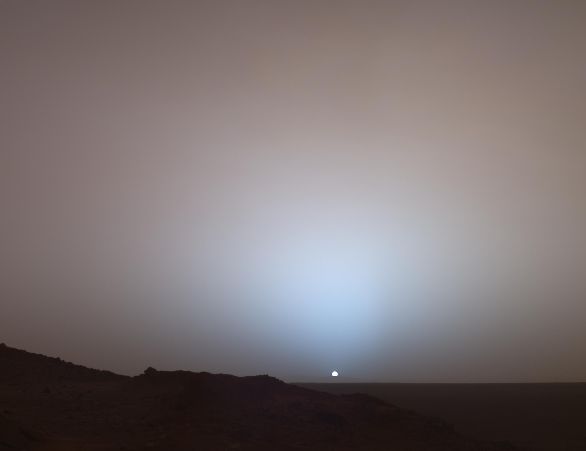
FULL SIZE TIFF Original Caption Released with Image: On May 19th, 2005, NASA's Mars Exploration Rover Spirit captured this stunning view as the Sun sank below the rim of Gusev crater on Mars. This Panoramic Camera (Pancam) mosaic was taken around 6:07 in the evening of the rover's 489th martian day, or sol. Spirit was commanded to stay awake briefly after sending that sol's data to the Mars Odyssey orbiter just before sunset. This small panorama of the western sky was obtained using Pancam's 750-nanometer, 530-nanometer and 430-nanometer color filters. This filter combination allows false color images to be generated that are similar to what a human would see, but with the colors slightly exaggerated. In this image, the bluish glow in the sky above the Sun would be visible to us if we were there, but an artifact of the Pancam's infrared imaging capabilities is that with this filter combination the redness of the sky farther from the sunset is exaggerated compared to the daytime colors of the martian sky. Because Mars is farther from the Sun than the Earth is, the Sun appears only about two-thirds the size that it appears in a sunset seen from the Earth. The terrain in the foreground is the rock outcrop "Jibsheet," a feature that Spirit has been investigating for several weeks (rover tracks are dimly visible leading up to "Jibsheet"). The floor of Gusev crater is visible in the distance, and the Sun is setting behind the wall of Gusev some 80 km (50 miles) in the distance. This mosaic is yet another example from MER of a beautiful, sublime martian scene that also captures some important scientific information. Specifically, sunset and twilight images are occasionally acquired by the science team to determine how high into the atmosphere the martian dust extends, and to look for dust or ice clouds. Other images have shown that the twilight glow remains visible, but increasingly fainter, for up to two hours before sunrise or after sunset. The long martian twilight (compared to Earth's) is caused by sunlight scattered around to the night side of the planet by abundant high altitude dust. Similar long twilights or extra-colorful sunrises and sunsets sometimes occur on Earth when tiny dust grains that are erupted from powerful volcanoes scatter light high in the atmosphere. Credit: NASA/JPL/Texas A&M/Cornell |
||
| FAIR USE NOTICE: This page contains copyrighted material the use of which has not been specifically authorized by the copyright owner. Pegasus Research Consortium distributes this material without profit to those who have expressed a prior interest in receiving the included information for research and educational purposes. We believe this constitutes a fair use of any such copyrighted material as provided for in 17 U.S.C § 107. If you wish to use copyrighted material from this site for purposes of your own that go beyond fair use, you must obtain permission from the copyright owner. | ||
|
|


