|
The Enigmas on Mars 24 |
||||
|
"INCA CITY" MOC wide-angle image E09-00186 .
Malin Space Systems: E09-00186.gif In this image you can see that the 'Inca City' appears to be buried in sand. From this view you can make out the circular pattern. The 'circular wall' in the upper left continues across gullies and rises. It would be interesting to dig at this location. |
||||
|
MGS MOC Release No. MOC2-319, 8 August 2002 .
"Inca City" is the informal name given by Mariner 9 scientists in 1972 to a set of intersecting, rectilinear ridges that are located among the layered materials of the south polar region of Mars. Their origin has never been understood; most investigators thought they might be sand dunes, either modern dunes or, more likely, dunes that were buried, hardened, then exhumed. Others considered them to be dikes formed by injection of molten rock (magma) or soft sediment into subsurface cracks that subsequently hardened and then were exposed at the surface by wind erosion.
The Mars
Global Surveyor (MGS) Mars Orbiter Camera (MOC)
has provided new information about the "Inca
City" ridges, though the camera's images still
do not solve the mystery. The new information
comes in the form of a MOC red wide angle
context frame taken in mid-southern spring,
shown above left and above right. The original
Mariner 9 view of the ridges is seen at the
center. The MOC image shows that the "Inca City"
ridges, located at 82?S, 67?W, are part of a
larger circular structure that is about 86 km
(53 mi) across. It is possible that this pattern
reflects an origin related to an ancient, eroded
meteor impact crater that was filled-in, buried,
then partially exhumed. In this case, the ridges
might be the remains of filled-in fractures in
the bedrock into which the crater formed, or
filled-in cracks within the material that filled
the crater. Or
both explanations could be wrong. While the
new MOC image shows that "Inca City" has a
larger context as part of a circular form, it
does not reveal the exact origin of these
striking and unusual martian landforms.
|
||||
|
"INCA CITY" ..
Mariner 9 image of the "Inca City". During the Mariner 9 mission, scientists found an unusual rectilinear structure associated with the south polar pitted terrain which they dubbed the "Inca City". Located near -80 degrees latitude and 64 degrees longitude, it is likely the result of wind deflation of deposits from underlying rough terrain. The "cells" in the image are about 4-5 kilometers in width. |
||||
|
"INCA CITY" ..
Viking 2 image of the region around the "Inca City". Viking 2 also imaged the region, but no evidence of the feature was visible in this image from orbit 225. It has been enhanced to bring out the details (noise reduced and contrast enhanced). The resolution of the original image is 0.544 km/pixel and is centered at -81.56 degrees latitude and 69.82 degrees longitude. Reproduced from volume 55 of the Mission to Mars: Viking Orbiter Images of Mars CD-ROM set. |
||||
|
"INCA CITY" ..
Viking 2 image of the region around the "Inca City". On a later orbit (421), Viking 2 again imaged the region. This time, the Inca City is clearly visible. This image was taken through the red filter. It has been enhanced to bring out the details (noise reduced and contrast enhanced). The resolution of this image is 0.146 km/pixel and is centered at -81.82 degrees latitude and 59.59 degrees longitude. Reproduced from volume 59 of the Mission to Mars: Viking Orbiter Images of Mars CD-ROM set. |
||||
|
Rectilinear Ridges In South Polar Layered Terrain ("Inca City") March 13, 1998 ..
(A) Portion of Viking
Orbiter
2 image 421B64, reproduced here (click on
icon) at full resolution of about 179 meters (585
feet) per picture element. The outlines of (B) is
shown. North is up, sun illumination is from the
top.
(B) Highest-resolution pre-Mars Global Surveyor view. Image is a portion of Mariner 9 DAS #8044333. Click on the small view above to see the image at full spatial resolution of approximately 100 meters (327 feet) per pixel. White box indicates location of MOC image (C). North is approximately "up", sun illumination is from top/upper right.
(C) Subframe of MOC image 7908 reproduced at full resolution, about 23 meters/pixel (75 feet/pixel). Picture shows an area approximately 20 x 14 km (12.4 x 8.7 miles) in size. Sun illumination is from upper left. This set of rectilinear, intersecting ridges was first seen in images taken by Mariner 9 in 1972 (see context frame B). The superficial resemblance to ancient ruins led to their informal name, "Inca City". As 1997 turned to 1998, MOC obtained this stunning high-resolution view during the 79th orbit of Mars Global Surveyor. The subframe depicted here is centered on 81.54?S latitude, 64.28?W longitude. Except for the small dark dots, everything in this image is covered by a moderately thin (probably less than a meter) layer of seasonal, CO2 frost. |
||||
|
Towards Lunar Archaeology Dr. Alexey V. Arkhipov Institute of Radio Astronomy, Nat. Acad. Sci. of Ukraine Excerpt Our Moon is a potential indicator of a possible alien presence near the Earth at some time during the past 4 billion years. To ascertain the presence of alien artifacts, a survey for ruinlike formations on the Moon has been carried out as a precursor to lunar archaeology. Computer algorithms for
semi-automatic, archaeological photo-reconnaissance
are discussed. About 80,000 Clementine lunar orbital
images have been processed, and a number of
quasirectangular patterns found. Morphological
analysis of these patterns leads to possible
reconstructions of their evolution in terms of
erosion. Two scenarios are considered: 1) the
collapse of subsurface quasi-rectangular systems of
caverns, and 2) the erosion of hills with
quasi-rectangular lattices of lineaments. We also
note the presence of embankment-like, "There are
times when a scientist must not be afraid to make
a fool of himself" Today, the idea of exploring the Moon for non-human artifacts is not a popular one among selenologists. Unfortunately, the detection of ET artifacts on the Moon is outside the interest of most selenologists due to their orientation towards natural formations and processes. It is also not of interest to mainstream archaeologists, as archaeology tends to adhere to a pre-Copernican geocentric point-of-view. SOURCE: The Society for Planetary SETI Research (SPSR) SOURCE: New Frontiers in Science, Vol. 1 No. 2, Winter 2002 PDF SETI In 1992, the Search for Alien Artifacts on the Moon (SAAM) — the first privately-organized archaeological reconnaissance of the Moon — was initiated. The justifications of lunar SETI, the wording of specific principles of lunar archaeology, and the search for promising areas on the Moon were the first stage of the project (1992-95). Preliminary results of lunar exploration6 show that the search for alien artifacts on the Moon is a promising SETI strategy, especially in the context of lunar colonization plans. SOURCE: The Society for Planetary SETI Research (SPSR) SOURCE: New Frontiers in Science, Vol. 1 No. 2, Winter 2002 PDF Additional reading: Arkhipov, A.V. “Earth-Moon System as
a Collector of Alien Artefacts”, J. Brit.
Interplanet. Soc., 1998, 51, Khorezmian Fortress
Koy-Krylgan-Kala
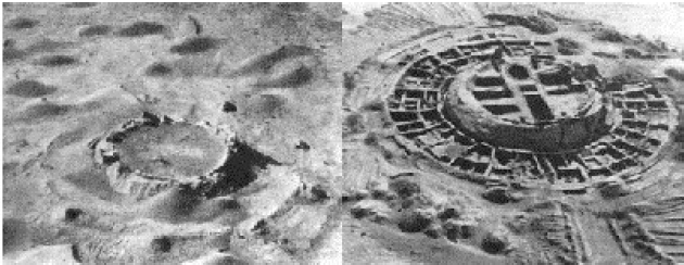
Fig. 1 The ancient Khorezmian fortress Koy-Krylgan-kala appeared as an impact crater on the air photo (left); its artificiality is obvious after the excavations in 1956 (right) [6].
The air view
of the Ancient Assyrian ruins of Assur resemble
the lunar lattice in Fig. 6.
Fig. 5 The
example of a wafer find (image LHD5472Q.287)
Fig. 2
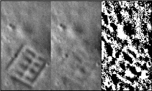
Simulation of probable HIRES view of ancient
settlement on the Moon (left). The erosion wipes
off the surface tracks of construction (center),
but the SAAM processing could reveal the
rectangular anomaly (right).
Alexey V. Arkhipov is a researcher at the Institute of Radio Astronomy, National Academy of Sciences of the Ukraine, and an Assistant professor at National Kharkov University. He has a Ph.D. in astrophysics and radio astronomy (Main Astronomical Observatory at the National Academy of Sciences of the Ukraine, Kyiv, 1998). The title of his dissertation was "New approaches to the problem of search for extra-terrestrial intelligence." Dr. Arkhipov's research involves the study of decametric radio emissions of Jupiter and non-classical approaches to SETI (e.g. archaeological reconnaissance of the Moon). He is the author of Selenites (http://www.setileague.org/articles/selenite.htm) and more than 100 technical and scientific articles. Dr. Arkhipov is the SETI League's Volunteer Coordinator for the Ukraine. He is a member of the SETI Center (Moscow), the Society for Planetary SETI Research (SPSR), and the SETI section of the Council on Astronomy of the Russian Academy of Sciences. His curriculum vitae can be found at http://www.setileague.org/admin/alexey.htm. |
||||
| FAIR USE NOTICE: This page contains copyrighted material the use of which has not been specifically authorized by the copyright owner. Pegasus Research Consortium distributes this material without profit to those who have expressed a prior interest in receiving the included information for research and educational purposes. We believe this constitutes a fair use of any such copyrighted material as provided for in 17 U.S.C § 107. If you wish to use copyrighted material from this site for purposes of your own that go beyond fair use, you must obtain permission from the copyright owner. | ||||
|
|

