|
The Enigmas on Mars 16 |
||||||
|
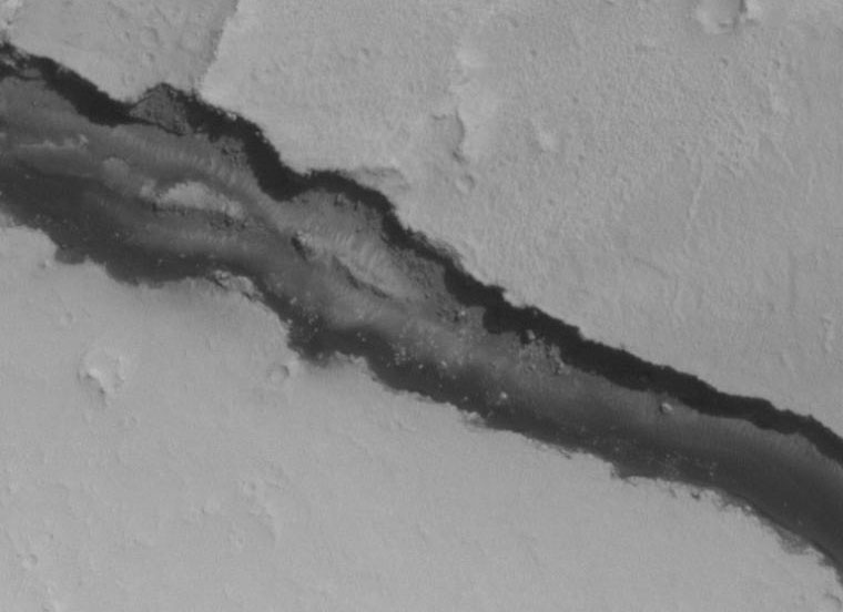
Martian Rivers .
The area within the river bed is darker that the surrounding land, indicating water is very near the surface , if not actually on it - Zorgon Image Source M1200756 |
||||||
|
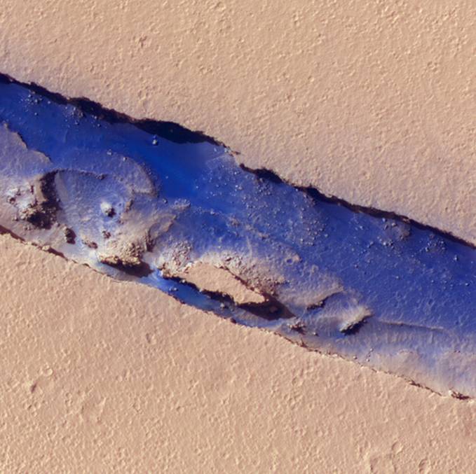
The River .
New picture from Mars. The sky is not really blue its that false color again. - John Lear |
||||||
|
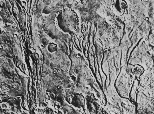
.
This is an image of a Martian river valley. The source of this picture is Windows to the Universe, at http://www.windows.ucar.edu/ at the University Corporation for Atmospheric Research (UCAR). ©1995-1999, 2000 The Regents of the University of Michigan; ©2000-04 University Corporation for Atmospheric Research. All Rights Reserved. |
||||||
|
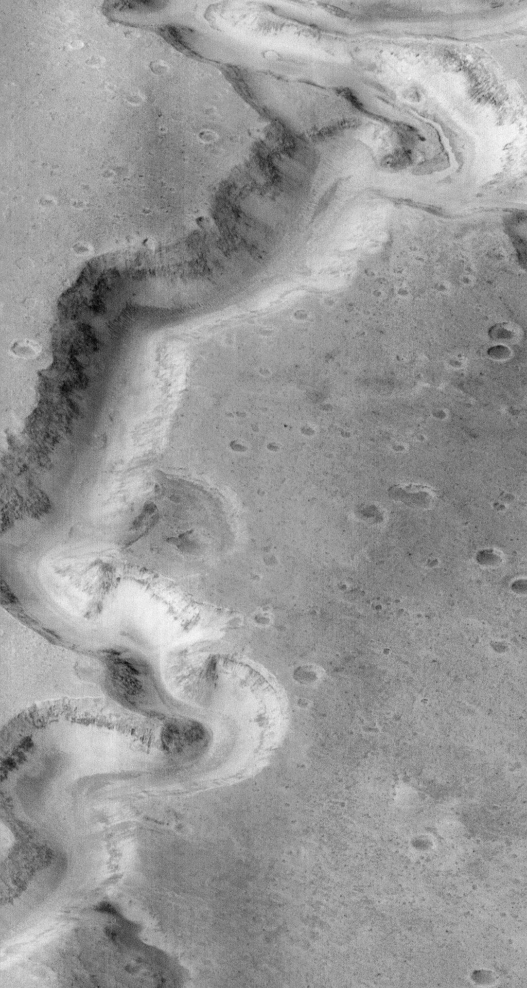
A Martian River Bed? February 5, 1998 .
This canyon on the surface of Mars appears to have been carved by flowing water. Known as Nanedi Vallis, the terraces and channels visible within the canyon strongly suggest that a river of water once ran here. But the lack of smaller surface channels and other features argue that the valley was formed by a surface collapse. Further images of Martian valley systems will help distinguish the degree to which these processes affected the Martian surface. This image was recorded on January 8th by the Mars Global Surveyor's camera during its 87th orbit of the red planet. The area pictured is about 6 miles wide. High resolution versions of the image show features that are as small as 40 feet across. - Credit: MGS Project, JPL, NASA |
||||||
|
and Surface Runoff on Mars |
||||||
|
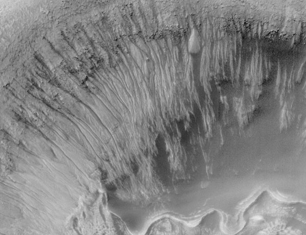
Newton Crater: Evidence for Recent Water on Mars 2000 June 26 .
What could have formed these unusual channels? Inside a small crater that lies inside large Newton Crater on Mars, numerous narrow channels run from the top down to the crater floor. The above picture covers a region spanning about 3000 meters across. These and other gullies have been found on Mars in recent high-resolution pictures taken by the orbiting Mars Global Surveyor robot spacecraft. Similar channels on Earth are formed by flowing water, but on Mars the temperature is normally too cold and the atmosphere too thin to sustain liquid water. Nevertheless, many scientists now hypothesize that liquid water did burst out here from underground Mars, eroded the gullies, and pooled at the bottom as it froze and evaporated. If so, life-sustaining ice and water might exist even today below the Martian surface -- water that could potentially support a human mission to Mars. Research into this exciting possibility is sure to continue! - Credit: Malin Space Science Systems, MGS, JPL, NASA
|
||||||
|
.
Mars is the planet most resembling Earth. It contains unambiguous evidence for the activity of past and present water, and is probably the most likely to host or have hosted extant or extinct life. Studies of the history and action of water on Mars are of great importance in this regard. Our studies will model the hydrothermal and low-temperature alteration of crustal minerals and rocks by water, and team members will combine this with data from Earth observations and recent Mars missions to assess its water inventory and habitability. The detection by the Mars Global Surveyor of copious ground ice and recently carved gullylike landforms raises the possibility that liquid water is close to the surface of present-day Mars. - SOURCE Comments:
|
||||||
|
New Gully Deposit in a Crater in Terra Sirenum .
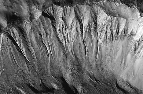
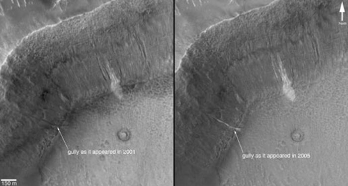
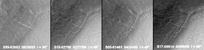
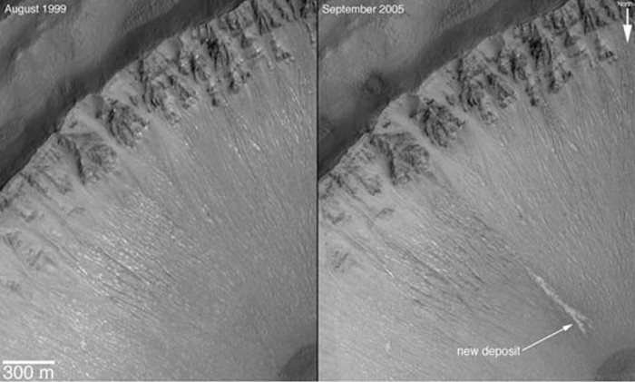
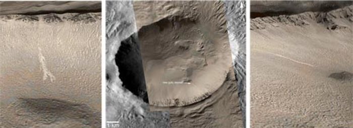
12.06.06 In June 2000, we reported the discovery, using the Mars Global Surveyor's Mars Orbiter Camera, of very youthful-looking gullies found on slopes at middle and high latitudes on Mars. Since that time, tens of thousands of gullies have been imaged by all of the Mars orbiting spacecraft: Mars Global Surveyor, Mars Odyssey, Mars Express and Mars Reconnaissance Orbiter. During the years since the original June 2000 report, the Mars Global Surveyor's camera was used to test the hypothesis that the gullies may be so young that some of them could still be active today. The test was very simple: re-image gullies previously seen by the camera and see if anything has changed. In two cases, something changed. One of those cases is presented here. A gully on the wall of an unnamed crater in Terra Sirenum, at 36.6 degrees south, 161.8 degrees west, was initially imaged by the camera on Dec. 22, 2001 (Figure A, left). It showed nothing noteworthy at the location where a change would later be observed, but a group of nearby gullies exhibited an unusual patch of light-toned material. As part of our routine campaign to re-image gully sites using the camera, another image of this location was acquired on April 24, 2005. A new light-toned deposit had appeared in what was otherwise a nondescript gully (Figure A, right). This deposit was imaged again by the camera on Aug. 26, 2005, at a time when the sun angle and season were the same as in the original December 2001 image, to confirm that indeed the light-toned feature was something new, not just a trick of differing lighting conditions. In August 2005, the feature was still present.
The light tone of the new gully deposit, and that of the older, neighboring gullies, is intriguing. We cannot know from these images whether the light tone indicates that ice is still present in and on the surface of the deposit. Indeed, ice may not be likely: under present conditions on the surface of Mars, ice would be expected to have sublimed, or vaporized, away fairly shortly after the new deposit formed. However, the light-toned material could be frost that forms and re-forms frequently as trapped water-ice sublimes and "exhales" from within the deposit. Alternatively, the light-tone may result if the deposit consists of significantly finer grains (for example, fine silt) than the surrounding surfaces, or if the deposit's surface is covered with minerals such as salts formed as water evaporated from the material.
The Mars Global Surveyor mission is managed for NASA's Office of Space Science, Washington, by NASA's Jet Propulsion Laboratory, Pasadena, Calif., a division of the California Institute of Technology, also in Pasadena. Lockheed Martin Space Systems, Denver, developed and operates the spacecraft. Malin Space Science Systems, San Diego, Calif., built and operates the Mars Orbiter Camera. For more information about images from the Mars Orbiter Camera, see http://www.msss.com/mgs/moc/index.html |
||||||
|
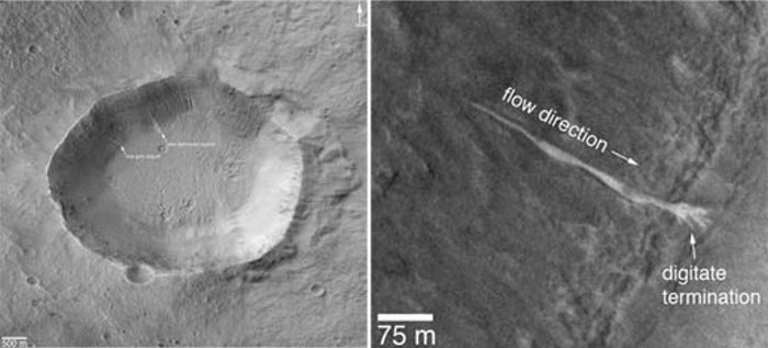
New Gully Deposit in a Crater in the Centauri Montes Region .
12.06.06 Two Martian southern mid-latitude craters have new light-toned deposits that formed in gully settings during the course of the Mars Global Surveyor mission. Images from the Mars Orbiter Camera documented one case in an unnamed crater in Terra Sirenum, described in an accompanying release (click here: PIA09027). The second case, in an unnamed crater in the Centauri Montes region, east of the Hellas Basin, is described here. Gullies were first described by Mars Orbiter Camera scientists in June 2000, and many examples were presented in our June 2000 web releases and in a paper published in the journal Science. Additional examples of these middle and high-latitude landforms can be seen among the other more than 1,600 web releases. The new gully deposit in an unnamed crater in the Centauri Montes region is located near 38.7 degrees south latitude, 263.3 degrees west longitude. Like the new gully deposit in Terra Sirenum, this one has a light tone relative to its surroundings. It is on an equator-facing slope on which numerous narrow gully channels occur. As this slope is always in sunlight during the afternoons when Mars Global Surveyor passes overhead, the gullies always appear somewhat "washed out," just as craters on a full Moon do when viewed from Earth with a telescope. The new, light-toned flow was first noticed by the Mars Orbiter Camera science operations team in an image acquired on Sept. 10, 2005. Re-examination of other images of this crater showed that the new deposit had actually been present on Feb. 21, 2004, when the distal (down-slope) end of the deposit was captured in other images. In February 2004, the deposit had gone unnoticed because only a small portion of it was imaged. This location was first imaged by the Mars Orbiter Camera on Aug. 30, 1999. The deposit was not present at that time. Thus, it formed between Aug. 30, 1999 and Feb. 21, 2004. Roughly 20 percent brighter than the surface as it
appeared before
the flow occurred, the new deposit exhibits
characteristics consistent
with transport and deposition of a fluid that behaved
like liquid water
and likely transported some fine-grained sediment
along with it. The distal
end of the flow broke into several branches, or
digits, and the material
diverted and flowed around low obstacles. As with the
example in Terra
Sirenum, the depth of the flow is too thin to be
measured in 1.5-meter-per-pixel
(1.7-yard-per-pixel) images, so a very small volume of
liquid and sediment
was involved. While the material flowed and easily
budded into several
branches, it also must have moved slow enough to not
topple over some of
the low obstacles in its path.
The new light-toned flow, by itself, does not prove that liquid water was involved in its genesis. However, this observation and the similar light-toned flow in Terra Sirenum together show that some gully sites are indeed changing today, providing tantalizing evidence there might be sources of liquid water beneath the surface of Mars right now. In both cases, these new flows may be indicating the locations of aquifers (subsurface rocks saturated with water) that could be detected by orbiting, ground-penetrating radar systems such as the Mars Express Mars Advanced Radar for Subsurface and Ionosphere Sounding or the Mars Reconnaissance Orbiter's Mars Shallow Subsurface Radar. The Mars Global Surveyor mission is managed for NASA's Office of Space Science, Washington, by NASA's Jet Propulsion Laboratory, Pasadena, Calif., a division of the California Institute of Technology, also in Pasadena. Lockheed Martin Space Systems, Denver, developed and operates the spacecraft. Malin Space Science Systems, San Diego, Calif., built and operates the Mars Orbiter Camera. For more information about images from the Mars Orbiter Camera, see http://www.msss.com/mgs/moc/index.html |
||||||
|
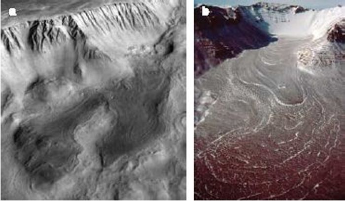
Pack Ice Spotted Near the Mars Equator .
|
||||||
|
Glacier at Base of Olympus Mons Volcano on Mars .
|
||||||
|
Collection of Articles about Water on Mars . NASA - Water on Mars - Does water STILL flow on Mars? NASA - Water on Mars - Evidence of liquid water on Mars boosts astrobiology. NASA - Water on Mars - Hope Springs Eternal NASA - Water on Mars - It looks like mud, but can't be mud NASA - Water on Mars - Making a Splash on Mars NASA - Water on Mars - NASA announces discovery of evidence of water on Mars NASA - Water on Mars - Odyssey Finds Water Ice in Abundance Under Mars' Surface NASA - Water on Mars - Part 1 NASA - Water on Mars - Part 2 NASA - Water on Mars - Recent Glaciers, Volcanoes and Flowing Water on Mars NASA - Water on Mars - Surface Water Possible Under Marslike Conditions NASA - Water on Mars - The Politics of Water |
||||||
| FAIR USE NOTICE: This page contains copyrighted material the use of which has not been specifically authorized by the copyright owner. Pegasus Research Consortium distributes this material without profit to those who have expressed a prior interest in receiving the included information for research and educational purposes. We believe this constitutes a fair use of any such copyrighted material as provided for in 17 U.S.C § 107. If you wish to use copyrighted material from this site for purposes of your own that go beyond fair use, you must obtain permission from the copyright owner. | ||||||
|
|
