|
The Enigmas on Mars 03 |
|||||||
|
The Evidence for Water On Mars Part Two: The Martian "Blue Berries" .
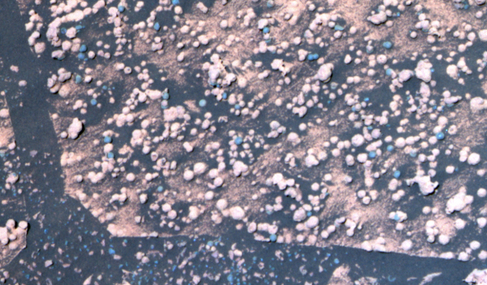
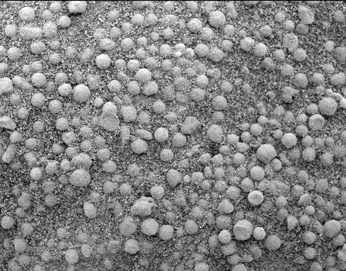
This microscopic image, taken at the outcrop region dubbed "Berry Bowl" near the Mars Exploration Rover Opportunity's landing site, shows the sphere-like grains or "blueberries" that fill Berry Bowl. The "triple berry" seen in the center of the microscopic image is intriguing to scientists because it reveals a clue about how the blueberries formed. Spheres formed from impacts or volcanoes do not tend to mold together like the spheres seen in the microscopic image. Spheres from impacts or craters are usually round or teardrop-shaped from flying in the air and freezing before hitting the ground. Any droplets of magma that combine with other droplets usually grow into a single mass in a spherical, dumbbell, or teardrop shape. In contrast, concretions could form this triple berry shape. Concretions are spherical mineral structures formed by groundwater percolating through porous rocks. On Earth, as concretions grow in close proximity to each other, their outer edges often intersect each other, giving an appearance like a triple soap bubble. Mineral in Mars 'Berries' Adds to Water Story - March 18, 2004 A major ingredient in small mineral spheres analyzed by NASA's Mars Exploration Rover Opportunity furthers understanding of past water at Opportunity's landing site and points to a way of determining whether the vast plains surrounding the site also have a wet history. The spherules, fancifully called blueberries although they are only the size of BBs and more gray than blue, lie embedded in outcrop rocks and scattered over some areas of soil inside the small crater where Opportunity has been working since it landed nearly two months ago. Individual spherules are too small to analyze with the composition-reading tools on the rover. In the past week, those tools were used to examine a group of berries that had accumulated close together in a slight depression atop a rock called "Berry Bowl." The rover's Mössbauer spectrometer, which identifies iron-bearing minerals, found a big difference between the batch of spherules and a "berry-free" area of the underlying rock. "This is the fingerprint of hematite, so we conclude that the major iron-bearing mineral in the berries is hematite," said Daniel Rodionov, a rover science team collaborator from the University of Mainz, Germany. On Earth, hematite with the crystalline grain size indicated in the spherules usually forms in a wet environment. Scientists had previously deduced that the martian spherules are concretions that grew inside water-soaked deposits. Evidence such as interlocking spherules and random distribution within rocks weighs against alternate possibilities for their origin. Discovering hematite in the rocks strengthens this conclusion. It also adds information that the water in the rocks when the spherules were forming carried iron, said Dr. Andrew Knoll, a science team member from Harvard University, Cambridge, Mass. "The question is whether this will be part of a still larger story," Knoll said at a press briefing today at NASA's Jet Propulsion Laboratory, Pasadena, Calif. Spherules below the outcrop in the crater apparently weathered out of the outcrop, but Opportunity has also observed plentiful spherules and concentrations of hematite above the outcrop, perhaps weathered out of a higher layer of once-wet deposits. The surrounding plains bear exposed hematite identified from orbit in an area the size of Oklahoma -- the main reason this Meridiani Planum region of Mars was selected as Opportunity's landing site. "Perhaps the whole floor of
Meridiani Planum has a
residual layer of blueberries," Knoll suggested. "If
that's true, one might
guess that a much larger volume of outcrop once
existed and was stripped
away by erosion through time."
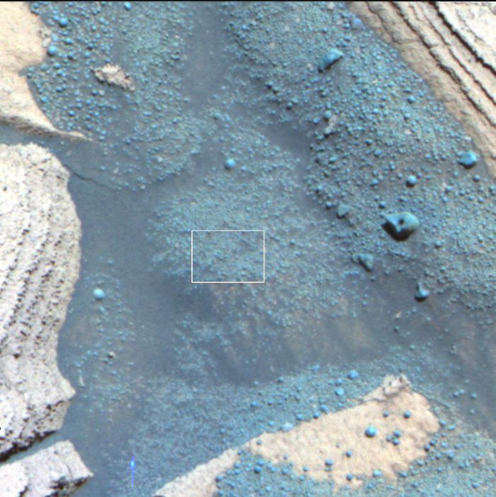
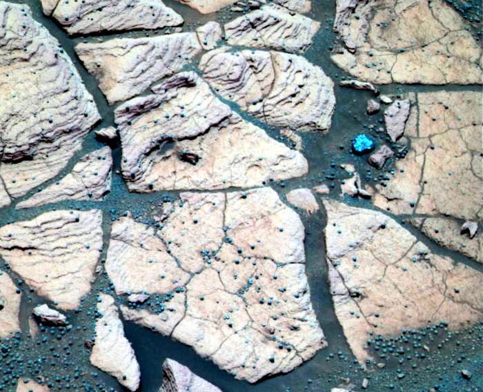
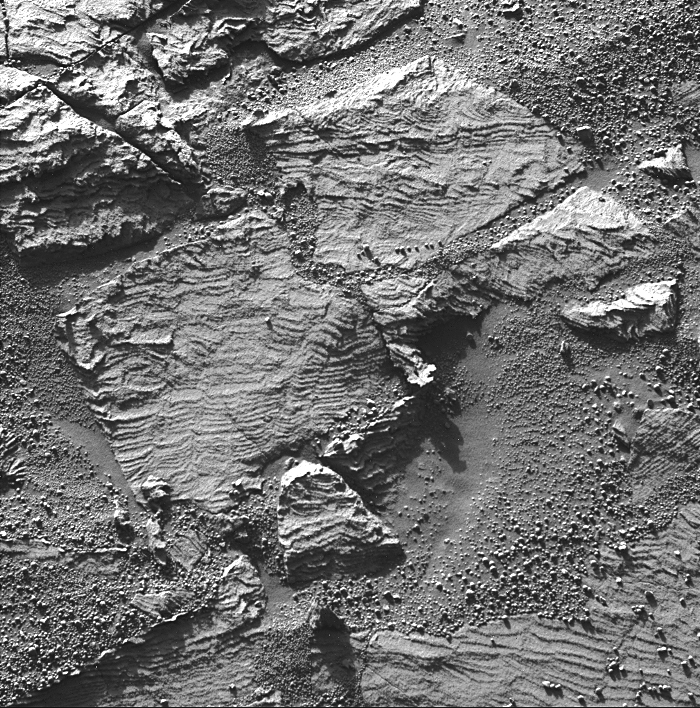
NASA's Mars Exploration Rover Opportunity is examining a type of rougher-textured, lighter-colored round pebbles that appear to be related to the smoother, darker spherules nicknamed "blueberries." The rover has found blueberries, which are actually gray, to be plentiful in Mars' Meridiani Planum region. This is a
false-color composite
image taken with the Mars Exploration Rover
Opportunity's panoramic camera.
It shows part of a rock called "Bylot" in the
"Axel Heiberg" outcrop area
low inside "Endurance Crater." A mixture of
blueberries and the lighter-colored
spherules, nicknamed "popcorn," lie on top of the
rock. The image shows
what appear to be, based on color, partially
exposed blueberries inside
popcorn spherules. Also visible are several
irregular, gray fragments that
may be pieces of blueberries scattered over the
sand at the bottom of the
image.
|
|||||||
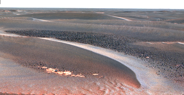
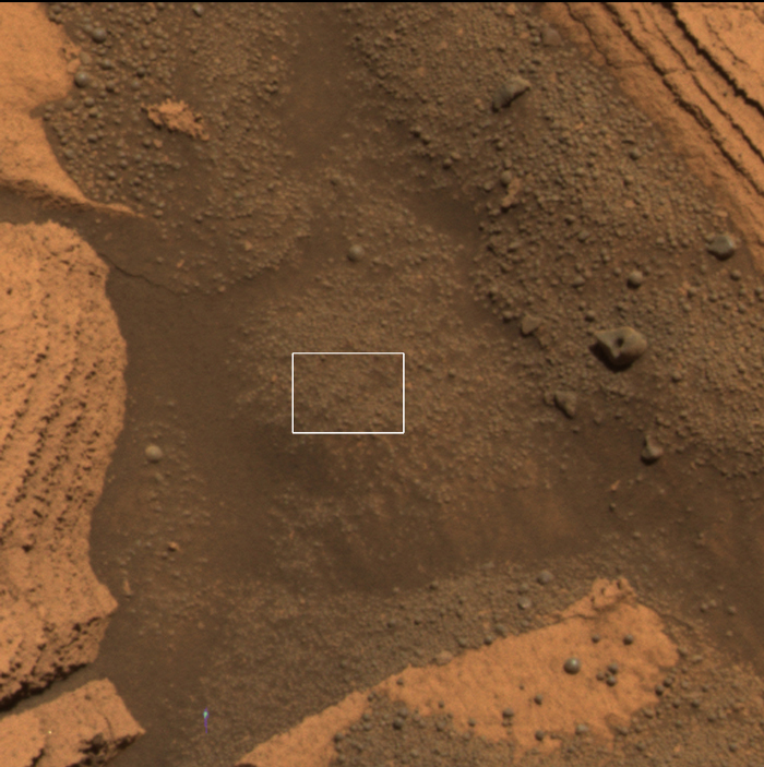
A Peek into 'Alamogordo Creek' - June 15, 2006 On its 825th Martian day (May 20, 2006), NASA's Mars Exploration Rover Opportunity stopped for the weekend to place its instrument arm onto the soil target pictured here, dubbed "Alamogordo Creek." Two views from the panoramic camera, acquired at about noon local solar time, are at the top. Below them is a close-up view from the microscopic imager. At upper left, a false-color view emphasizes differences among materials in rocks and soil. It combines images taken through the panoramic camera's 753-nanometer, 535-nanometer and 432-nanometer filters. At upper right is an approximately true-color rendering made with the panoramic camera's 600-nanometer, 535-nanometer and 480-nanometer filters. The microscopic-imager frame covers the area outlined by the white boxes in the panoramic-camera views, a rectangle 3 centimeters (1.2 inches) across. As Opportunity traverses to the south, it is analyzing soil and rocks along the way for differences from those seen earlier. At this site, the soil contains abundant small spherical fragments, thought to be hematite-rich concretions, plus finer-grained basaltic sand. Most of the spherical fragments seen in the microscopic image are smaller than those first seen at the rover's landing site in "Eagle Crater," some five kilometers (3.1 miles) to the north. However, a few larger spherical fragments and other rock fragments can also be seen in the panoramic-camera images. |
|||||||
|
|||||||
|
Fields of Hematite Opportunity Rover Landing Site .
WATER ON MARS...IN THE PAST The thermal emission imaging system (THEMIS) on Odyssey is both an infrared camera and a visible camera. It has captured telltale signs of past water on Mars. In four locations on Mars, THEMIS has detected high levels of hematite, a mineral that on Earth forms most often in the presence of liquid water. Discoveries by THEMIS and its predecessor instrument(TES (thermal emission spectrometer) on the Mars Global Surveyor orbiter) led the 2003 Mars Exploration Rover mission team to choose Meridiani Planum as a landing site for its hematite content. Since landing, data from the Opportunity rover's science instruments, including the miniature thermal emission spectrometer (mini-TES) has since confirmed THEMIS' results that the area was once covered in water. "The morphology and thermal properties of the Meridiani Planum region indicate that the hematite-bearing area was deposited in a standing body of water that extended over 100,000 square kilometers (300 miles by 100 miles or about the size of Oklahoma), with smaller bodies of water in nearby crater basins," said Christensen. THEMIS, along with Christensen's two other instruments at Mars (TES on Mars Global Surveyor and mini-TES on the rovers), has shown that liquid water could have been in a few areas within the equatorial region of Mars for thousands or tens of thousands of years. |
|||||||
|
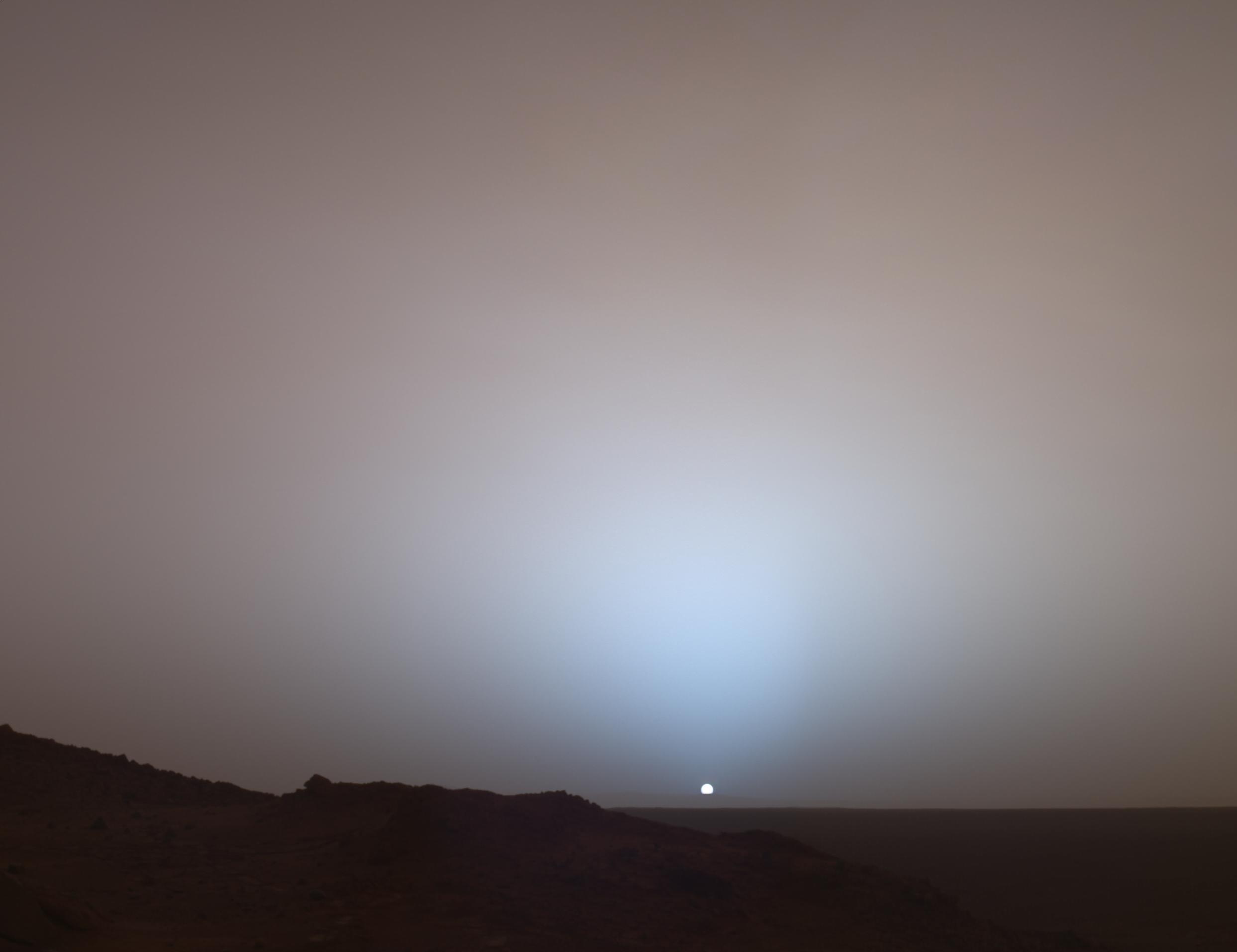
Sunset on Mars An Image Frozen in Time Spirit Rover .
On May 19th, 2005, NASA's Mars Exploration Rover Spirit captured this stunning view as the Sun sank below the rim of Gusev crater on Mars. This Panoramic Camera (Pancam) mosaic was taken around 6:07 in the evening of the rover's 489th martian day, or sol. Spirit was commanded to stay awake briefly after sending that sol's data to the Mars Odyssey orbiter just before sunset. This small panorama of the western sky was obtained using Pancam's 750-nanometer, 530-nanometer and 430-nanometer color filters. This filter combination allows false color images to be generated that are similar to what a human would see, but with the colors slightly exaggerated. In this image, the bluish glow in the sky above the Sun would be visible to us if we were there, but an artifact of the Pancam's infrared imaging capabilities is that with this filter combination the redness of the sky farther from the sunset is exaggerated compared to the daytime colors of the martian sky. Because Mars is farther from the Sun than the Earth is, the Sun appears only about two-thirds the size that it appears in a sunset seen from the Earth. |
|||||||
|
Opportunity Rover .
For the first time in almost seven years, scientists watched a blue-and-red sunset from Mars, courtesy of NASA's Opportunity rover. The new view is appealing from an inspirational as well as a scientific point of view, scientists said Thursday. "You're observing the sun setting on another planet — how often do you get to do that?" Cornell astronomer Jim Bell, team leader for the Mars rovers' panoramic cameras, told journalists at NASA's Jet Propulsion Laboratory in Pasadena, Calif. "It's important not to forget that what we're doing does have special inspirational moments like this." |
|||||||
|
.
Viking 1 Lander image of a martian sunset over Chryse Planitia. In this image the sun is 2 degrees below the local horizon. The banding in the sky is an artifact produced by the incremental brightness levels of the camera. This image was taken on the 30th martian day (sol) after touchdown, at 19:13 local time. The camera is pointing towards the southwest. |
|||||||
|
Blue Skies over Mars .
This true color image was taken in the twilight by the rover Pathfinder on Mars in August 1997. The clouds are of the same type as those discovered by SPICAM at a much higher altitude. The sky on Mars is BLUE - Zorgon |
|||||||
|
Water Once Filled Mars Opportunity Rover Landing Site By Tariq Malik
The landing site of the Mars rover Opportunity was once drenched with water, providing an environment that could have supported life, NASA scientists announced at a press conference today. Water once covered or infused the small crater in which the rover sits, then it gradually evaporated away leaving high concentrations of salt behind. A lake or ocean at the site and beyond might have once been the size of one of Earth's Great Lakes. Or the area might have been loaded with groundwater that rarely if ever reached the surface. And while no signs of biological activity are likely to be uncovered by the current mission, scientists are ecstatic that they now know exactly where to look for past life on Mars. "We think we've found enough evidence at the Opportunity site that liquid water was in abundance for some period of time," said Benton Clark III, a Mars Exploration Rover (MER) team member, in a telephone interview prior to the press conference. Researchers still don't know how long the liquid water lasted and whether any remains today. "That's the $64,000 question," Clark, who is also chief scientist of space exploration at Lockheed Martin, told SPACE.com. |
|||||||
| FAIR USE NOTICE: This page contains copyrighted material the use of which has not been specifically authorized by the copyright owner. Pegasus Research Consortium distributes this material without profit to those who have expressed a prior interest in receiving the included information for research and educational purposes. We believe this constitutes a fair use of any such copyrighted material as provided for in 17 U.S.C § 107. If you wish to use copyrighted material from this site for purposes of your own that go beyond fair use, you must obtain permission from the copyright owner. | |||||||
|
|