|
The Enigmas on Mars |
||||
|
.
The Blue Bird Files
|
||||
|
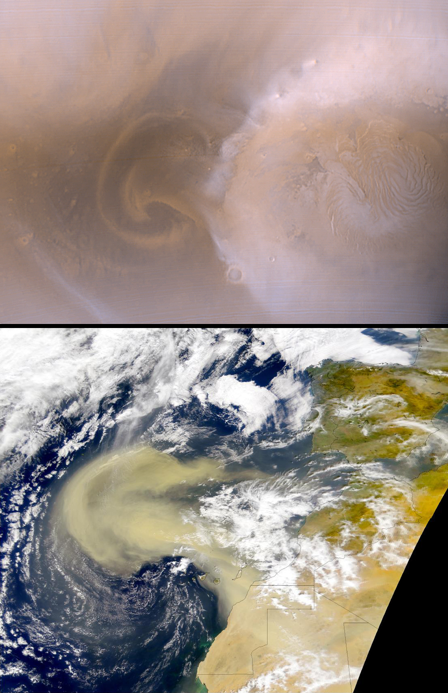
In this figure, we compare a recent
dust storm on Mars
with one that occurred earlier this year on Earth.
The top image shows
a martian north polar dust storm observed on 29
August 2000. This image
is part of the Mars Orbiter Camera (MOC) daily
global map--a low resolution,
two-color view of Mars acquired from pole to pole
every orbit. The storm
is moving as a front, outward from a central "jet,"
and marginal "vortices"
can be seen. In this image it extends about 900 km
(560 mi) out from the
north polar seasonal frost cap. The region on the
right side of the Mars
picture includes the north pole. The bottom image
shows a terrestrial dust
storm, seen in a SeaWiFS image, acquired on 26
February 2000. This storm
exends about 1800 km (1100 mi) off the coast of
northwest Africa near the
Earth's equator. Both images are shown at the same
scale; 4 km (2.5 mi)
per pixel.
Image Source: MGS MOC Release No. MOC2-249, 12 September 2000 |
||||
|
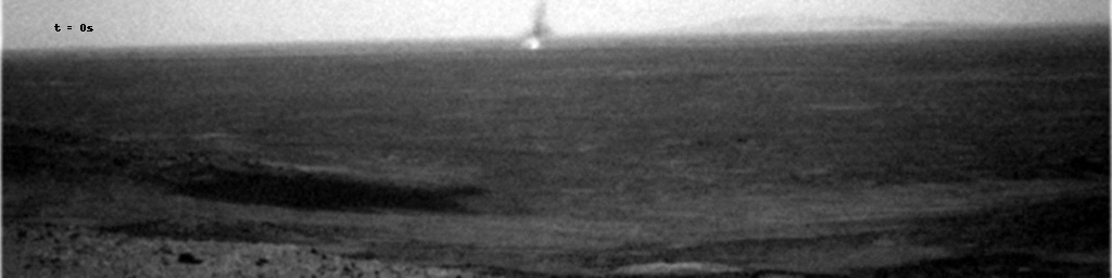
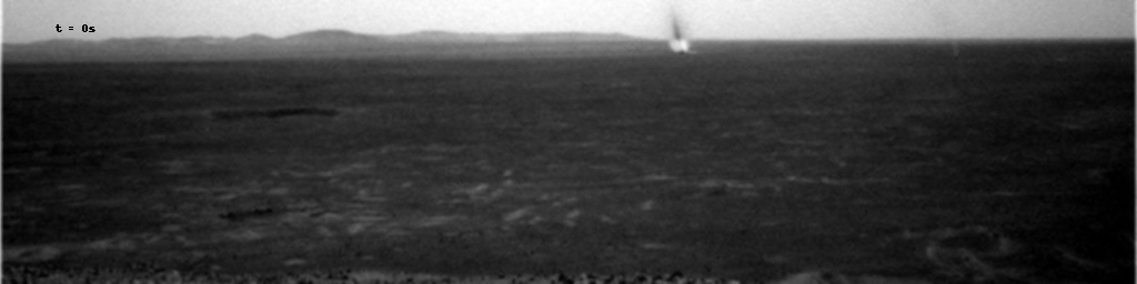
Dust Devils on Mars .
A Martian Dust Devil Passes
Explanation: What goes there across the plains of Mars? A dust devil. For the first time, definitive movies of the famous spinning dust towers have been created from ground level. The robot rover Spirit has now imaged several dust devils from its hillside perch just within the past two months. Each image in the above sequence was taken about 20 seconds apart. Inspection of the digitally resized images show the passing dust devil raising Martian dust so thick that it casts a shadow. The new dust devil movies have been made possible by a new hybrid interaction system where the robot Spirit on Mars takes many images and humans on Earth inspect thumbnails and decide which full resolution images to send back. |
||||
|
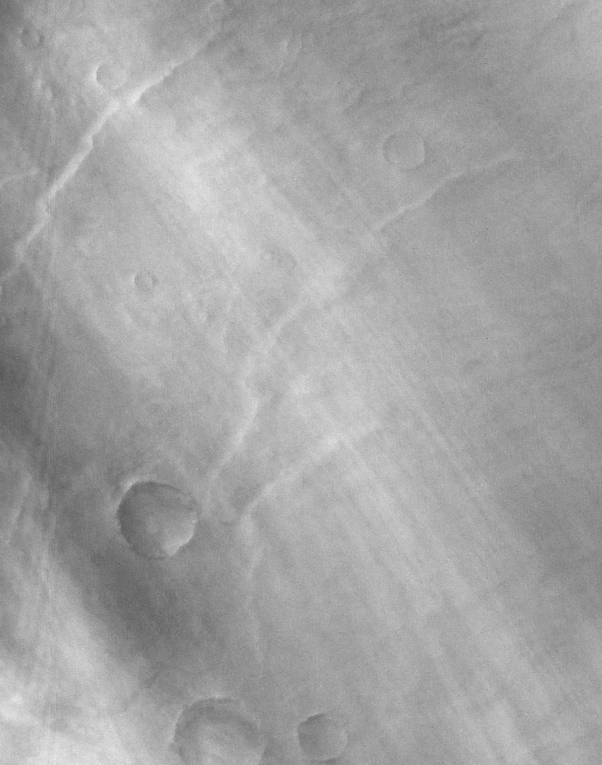
A Dust Devil Crater on Mars .
A Dust Devil Crater on Mars
Explanation: What caused the streaks in this Martian crater? Since the above image shows streaks occurring both inside and outside the crater, they were surely created after the crater-causing impact. Newly formed trails like these presented researchers with a tantalizing martian mystery but have now been identified as likely the work of miniature wind vortices known to occur on the red planet - martian dust devils. Another example of wind processes on an active Mars, dust devils had been detected passing near the Viking and Mars Pathfinder landers. Such spinning columns of rising air heated by the warm surface are common in dry and desert areas on planet Earth. Typically lasting only a few minutes, they becoming visible as they pick up loose dust. On Mars, dust devils can be up to 8 kilometers high and leave dark trails as they disturb the bright, reflective surface dust. |
||||
|
A Dust Devil on Mars Climbs Crater Wall .
A Dust Devil on Mars
Explanation: Does the surface of Mars change? When inspecting yearly images of the Martian surface taken by the robot spacecraft Mars Global Surveyor currently orbiting Mars, sometimes new dark trails are visible. Although originally a mystery, the culprit is now usually known to be a dust devil, a huge swirling gas-cloud with similarities to a terrestrial tornado. Pictured above, a recent image has not only captured a new dark trail but the actual dust devil itself climbing a crater wall. Dust devils are created when Martian air is heated by a warm surface and begins to spin as it rises. Dust devils can stretch 8 kilometers high but usually last only a few minutes. |
||||
|
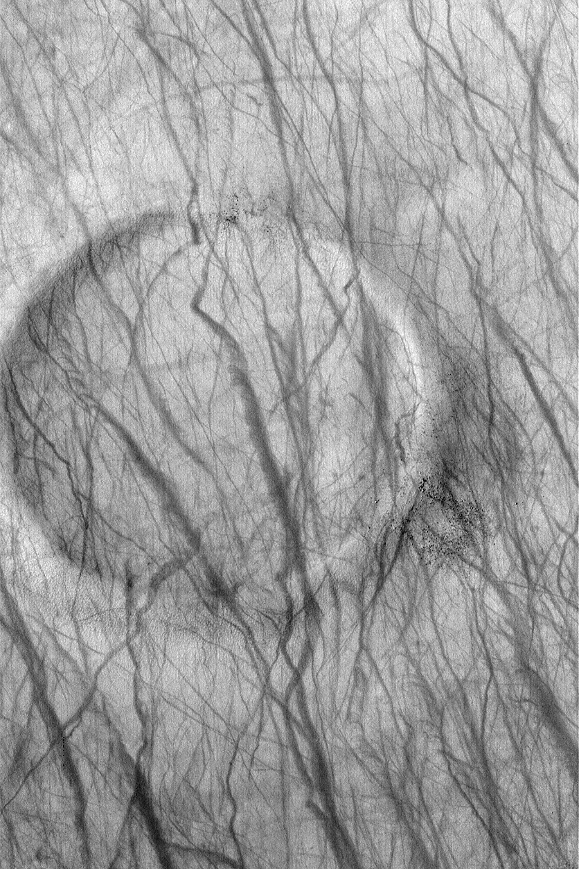
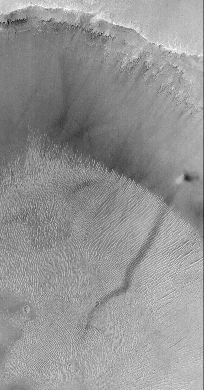
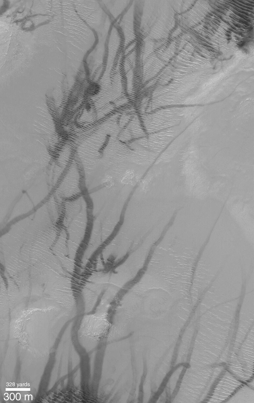
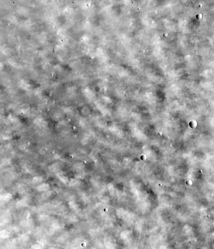
Martian Dust Devil Trails .
Martian Dust Devil Trails
Explanation: Who's been marking up Mars? This portion of a recent high-resolution picture from the orbiting Mars Global Surveyor spacecraft shows twisting dark trails criss-crossing a relatively flat rippled region about 3 kilometers wide on the martian surface. Newly formed trails like these presented researchers with a tantalizing martian mystery but have now been identified as likely the work of miniature wind vortices known to occur on the red planet - martian dust devils. Another example of wind processes on an active Mars, dust devils had been detected passing near the Viking and Mars Pathfinder landers. Such spinning columns of rising air heated by the warm surface are common in dry and desert areas on planet Earth. Typically lasting only a few minutes, they becoming visible as they pick up loose dust. On Mars, dust devils can be up to 8 kilometers high and leave dark trails as they disturb the bright, reflective surface dust. |
||||
|
Martian Dust Devils in Action Spirit Rover .
Source: NASA Mars Rovers |
||||
|
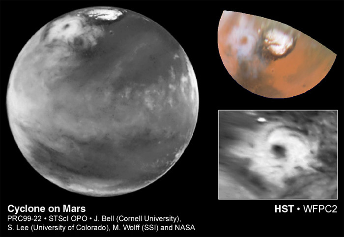
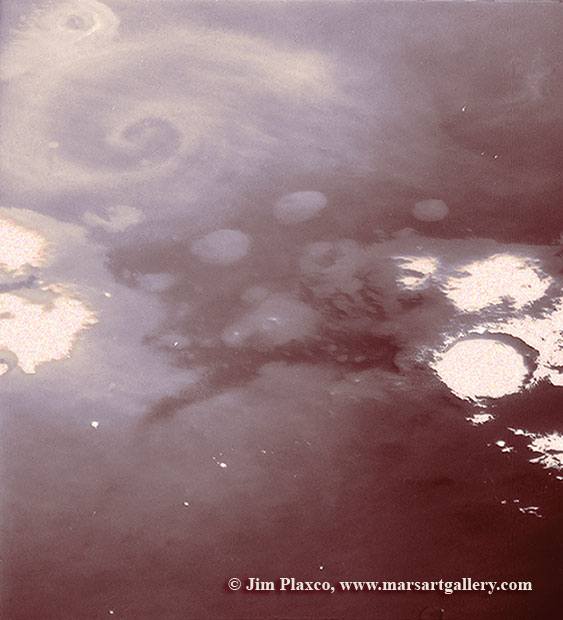
Colossal Polar Cyclone .
[left]: The discovery image of the Martian polar storm as seen in blue light (410 nm). The storm is located near 65 deg. N latitude and 85 deg. W longitude, and is more than 1000 miles (1600 km) across. The residual north polar water ice cap is at top. A belt of clouds like that seen in previous telescopic observations during this Martian season can also be seen in the planet's equatorial regions and northern mid-latitudes, as well as in the southern polar regions. The volcano Ascraeus Mons can be seen as a dark spot poking above the cloud deck near the western (morning) limb; this extinct volcano towers nearly 16 miles (25 km) above the surrounding plains, and is about 250 miles (400 km) across. [upper right]: Color polar view of the north polar region, showing the location of the storm relative to the classical bright and dark features in this area. The color composite data (410, 502, and 673 nm) indicate that the storm is fairly dust-free and therefore likely composed mostly of water ice clouds. The bright surface region beneath the eye of the storm can be seen clearly. This map covers the region north of 45 degrees latitude, and is oriented with 0 degrees longitude at the bottom. [lower right]: Enhanced orthographic view of the storm centered on 65 deg. N latitude, 85 deg. W longitude. The image has been processed to bring out additional detail in the storm's spiral cloud structures. The pictures were taken on April 27, 1999, with the NASA Hubble Space Telescope's Wide Field and Planetary Camera 2. Source - Cosmic Light |
||||
|
Cyclone Captured by Viking 1 Orbiter .
Image taken by the Viking spacecraft. Along the edge of the Martian polar cap, cyclonic disturbances are common during the late summer and fall. This storm system is located at the edge of the northern polar cap. In the foreground, frost can be seen as bright areas. This Viking 1 Orbiter image was acquired in June 1978 early in the northern hemisphere's summer. The image is of a region near the north polar cap, approximately 80º North, 160º West. This image was taken by the Viking 1 Orbiter when it was about 10,000 kilometers distant. As shown here, North is towards the left and East is up with the East-West dimension being approximately 500 kilometers long. What makes this image unique is the presence of the spiral, cyclonic cloud structure. In all their years of operation, the two Viking orbiters only observed four such storms. The exact nature of how such storms originate is a subject of debate. - Source |
||||
|
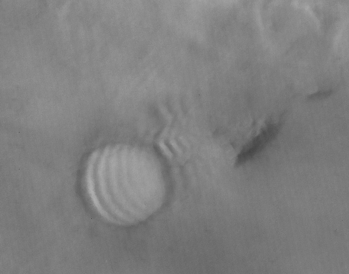
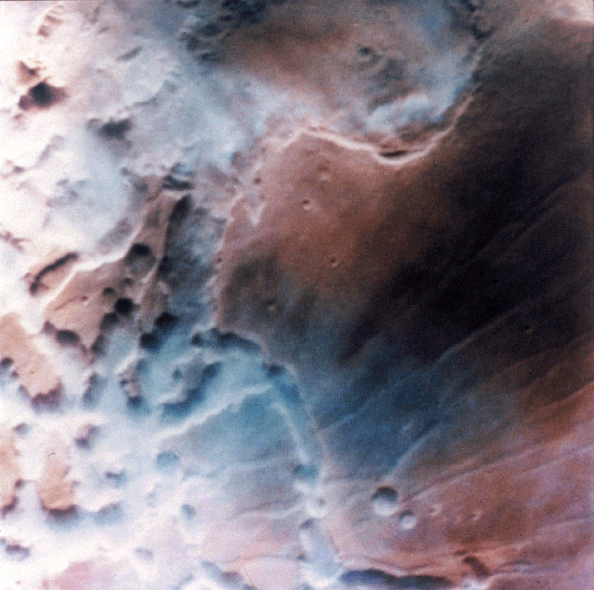
More Clouds on Mars Lee Wave Cloud .
Image taken by the Viking spacecraft. This is a good example of a lee wave associated with an impact crater. Note the wave periodicity in the clouds. |
||||
|
Crater with Wavy Fog MGS MOC Release No. MOC2-424, 17 July 2003 .
Craters near the edge of the retreating south polar seasonal frost cap often have fog in them, this time of year. This Mars Global Surveyor (MGS) Mars Orbiter Camera (MOC) wide angle red image was acquired just a few days ago on July 13, 2003. It shows a crater, 36 km (22 mi) across, that is enveloped in fog. This picture was taken as a context frame for a high resolution view that was intended to show dunes on the floor of the crater. That high resolution view was frustrated by thick fog that hid the dunes from view. This wide angle context frame shows that winds from the lower right (southeast) were blowing over the crater, causing the fog to bunch up in a wavy, rippled pattern. Winds streaming off the polar cap toward the north create a variety of patterns in the fogs formed by water ice or vapor as the seasonal cap retreats during southern spring. This picture is located at 66.4°S, 208.6°W, sunlight illuminates the scene from the upper left (northwest). Image Source: Malin Space Systems 2003/07/17 R07-00964 |
||||
|
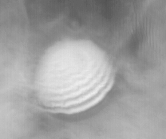
Wave Clouds .
Image taken by the Viking spacecraft. Wave clouds usually occur at the lee of a large obstacle. They are often found at the edge of the polar cap, and in the Tharsis and Lunae Planum regions of Mars. |
||||
|
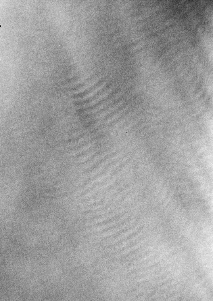
Cloud Streets .
Image taken by the Viking spacecraft. The cloud patterns illustrated by this image exhibits a double periodicity. These types of clouds usually occur close to the northern-polar cap and in the Tharsis and Syria Planum regions of Mars. |
||||
|
Streaky Clouds .
Image taken by the Viking spacecraft. Streaky clouds seem to be found most everywhere; however, they seem to be more concentrated in the highlands southwest of Syrtis Major on Mars. (Click image for larger view) |
||||
|
Fog .
Image taken by the Viking spacecraft. Fog often appears in low-lying areas. It typically occurs in the southern hemisphere especially in the Argyre and Hellas basins. It forms frequently in craters. Occasionally, it occurs in higher regions such as Sinus Sabaeus and Solis Planum. (Click image for larger view) |
||||
|
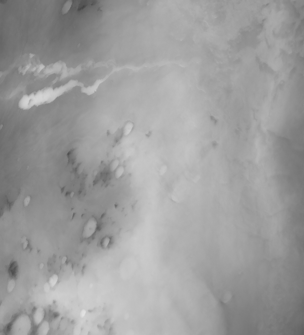
MGS MOC Release No. MOC2-528, 29 October 2003 .
Fog is a common occurrence in some areas of the retreating south polar seasonal frost cap. Fogs are commonly banked-up against steep slopes or found inside defrosting craters. This Mars Global Surveyor (MGS) Mars Orbiter Camera (MOC) image captured mid-afternoon fog banked against the layered walls of Chasma Australe, a trough in the south polar region of Mars. The frost-covered layers of Chasma Australe can be seen on the right side of this image, the billowy fog is to the left. Sunlight illuminates this scene from the upper left. The fog, probably composed of water ice crystals, casts shadows on the chasm wall. This picture is located near 83.5°S, 257.9°W, and covers an area 3 km (1.9 mi) wide. Image Source: Malin Space Systems 2003/10/29 M09 04025 |
||||
|
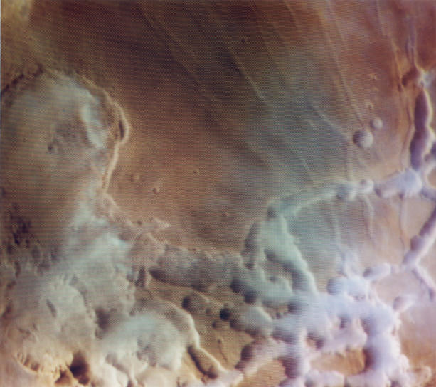
Water Clouds in Noctis Labyrinthis .
Image taken by the Viking spacecraft. This image shows early morning fog in the Noctis Labyrinthis, at the westernmost end of Valles Marineris. This fog, which is probably composed of water ice, is confined primarily to the low-lying troughs, but occasionally extends over the adjacent plateau. The region shown is about 300 kilometers (186 miles) across. (Click image for larger .tif view) |
||||
|
Colorful Water Clouds Over Mars .
Explanation: One place where water can be found on Mars is in clouds. In the above picture colorful water clouds are visible just after sunrise in and around a maze of canyons known as Noctis Labyrinthus (the labyrinth of the night). Scientists don't yet know, however, why these clouds formed, and why some stick to the canyons. One exciting possibility is that water sometimes condenses in shaded regions of the canyons, only to evaporate into clouds when exposed to the morning Sun. Water in any form on the Martian surface might be important to sustaining life and possible future human exploration. Viking Orbiter 1, which visited Mars in 1976, took the above picture. The region shown is about 100 kilometers across. SOURCE: NASA APOD April 17, 2001 |
||||
|
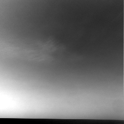
Wispy Clouds Passing Overhead Opportunity Rover Sol 950
Opportunity acquired images of clouds passing over Victoria Crater using the navigation camera on the rover's 950th sol (martian day) of exploration on Mars (Sept. 25, 2006). Both rovers will continue searching the Martian sky for clouds during solar conjunction. Left Navigation Camera Non-linearized Downsampled EDR acquired on Sol 950 of Opportunity's mission to Meridiani Planum at approximately 11:37:32 Mars local solar time. Credit: NASA/JPL |
||||
|
Wispy Afternoon Clouds Rover Opportunity Sol 956 .
NASA's Mars Exploration Rover Opportunity captured a view of wispy afternoon clouds, not unlike fair weather clouds on Earth, passing overhead on the rover's 956th sol, or Martian day (Oct. 2, 2006). With Opportunity facing northeast, the clouds appear to drift gently toward the west in this movie taken with the rover's navigation camera. The 10 frames, taken 32 seconds apart, show the formation and evolution of what are likely mid-level, convective water clouds. Such clouds are common near Mars' equator at this time of the Martian year. They have been observed by both of NASA's Mars Exploration Rovers, by satellites orbiting Mars, and by the Hubble Space Telescope. In this case, the clouds appear to develop at a fixed location, in the center of the frame about 25 degrees above the horizon. This style of origin suggests that a thermal plume is rising over a surface feature. In spite of apparent winds aloft, the thermal plume appears to remain stationary for the 5-minute duration of the movie. Though scientists have determined from the images that the wind bearing is east-northeast, approximately 80 degrees, it is not possible on the basis of the movie to unambiguously determine the height and speed of the clouds. Scientists estimate, based on models of atmospheric wind profiles and the apparent displacement of the clouds, that all of the clouds in the movie are at about the same height somewhere between 5 kilometers and 25 kilometers (3 to 20 miles) above the surface. The clouds are estimated to be moving at 2.5 meters per second, if they are low, to 12.5 meters per second, if they are high (8 feet per second to 41 feet per second). Like clouds on Earth, these Martian clouds are probably composed of ice crystals and possibly supercooled water droplets. They are similar in appearance to terrestrial cirrocumulus or high altocumulus clouds. On Earth, such clouds are relatively transient and consist of small, individual cloudlets arranged in rippled patterns. They usually form 6 kilometers to 12 kilometers (4 to 7 miles) above Earth's surface by a process known as convection, during which warm air rises and cools, with clouds condensing from the moist air once it has cooled sufficiently. These Martian clouds appear to be associated with a broader layer of ice-crystal clouds fanning out toward the upper right of the frames at the end of the movie. This is similar to the occurrence of terrestrial cirrocumulus and altocumulus clouds within layers of cirrus or cirrostratus clouds on Earth. Also apparent in this movie are prominent waves in the clouds, a result of the effect of gravity waves on cloud thickness, as on Earth. Though both rovers now have the ability to autonomously detect clouds, these images were taken prior to the first use of the new abilities. The images shown here were stored on Opportunity and were transmitted to Earth on sol 1056 (Jan. 12, 2007) during a routine communications pass. Image Credit: NASA/JPL/Texas
A&M/Cornell
|
||||
|
Dust Plume .
Image taken by the Viking spacecraft. This is an example of a dust plume in the Solis Planum region. This image was taken during the springtime for this region. Plumes are found primarily in the southern hemisphere, in highlands such as Syrtis Major and in elevated regions such as Tharsis. (Click image for larger view) |
||||
|
Planet Gobbling Dust Storms on Mars .
Mariner 9 arrived at Mars in 1971 -- the first spacecraft to orbit the Red Planet. Scientists were anxious to study the crisp new pictures it was expected to send back. Much of Mars had never been seen in any detail, and Mariner 9 would lift the veil at last. Their feelings must have been mixed indeed when the first images arrived at mission control and revealed .... a world-wide haze. The surface of the entire planet was hidden by the biggest dust storm anyone had ever seen! Only Olympus Mons, a giant volcano 24 kilometers high, peeked above the clouds. After a month the dust settled and Mariner 9 mapped the Red Planet with great success. Scientists have since learned that huge dust storms, dwarfing desert dust clouds on Earth, are fairly common on Mars. The Mariner 9 event still holds the record as the thickest and longest-lasting we have observed -- but perhaps not for long.
Mars dust storm viewed from orbit, note craters with snowy rims. |
||||
|
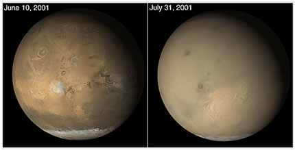
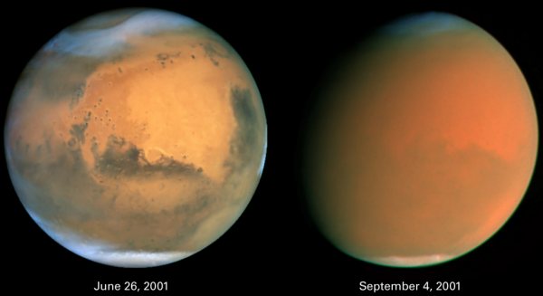
Planet Gobbling Dust Storms on Mars Part 2 .
Scientists Track "Perfect Storm" on Mars Both images are in natural color,
taken with Hubble's
Wide Field Planetary Camera 2.
Two dramatically different faces of our Red Planet neighbor appear in these comparison images showing how a global dust storm engulfed Mars with the onset of Martian spring in the Southern Hemisphere. When NASA's Hubble Space Telescope imaged Mars in June, the seeds of the storm were caught brewing in the giant Hellas Basin (oval at 4 o'clock position on disk) and in another storm at the northern polar cap. When Hubble photographed Mars in early September, the storm had already been raging across the planet for nearly two months obscuring all surface features. The fine airborne dust blocks a significant amount of sunlight from reaching the Martian surface. Because the airborne dust is absorbing this sunlight, it heats the upper atmosphere. Seasonal global Mars dust storms have been observed from telescopes for over a century, but this is the biggest storm ever seen in the past several decades. Mars looks gibbous in the right photograph because it is 26 million miles farther from Earth than in the left photo (though the pictures have been scaled to the same angular size), and our viewing angle has changed. The left picture was taken when Mars was near its closest approach to Earth for 2001 (an event called opposition); at that point the disk of Mars was fully illuminated as seen from Earth because Mars was exactly opposite the Sun. Source - Cosmic Light |
||||
|
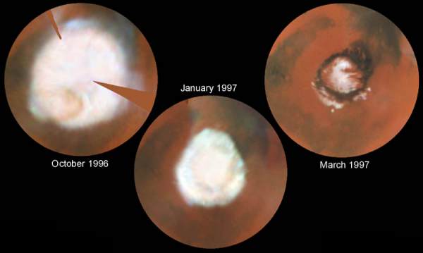
Seasonal Changes in the North Polar Ice Cap .
Steve Lee (Univ. Colorado), and NASA These images, which seem to have been taken while NASA's Hubble Space Telescope (HST) was looking directly down on the Martian North Pole, were actually created by assembling mosaics of three sets of images taken by HST in October, 1996 and in January and March, 1997 and projecting them to appear as they would if seen from above the pole. This first mosaic is a view which could not actually be seen in nature because at this season a portion of the pole would have actually been in shadow; the last view, taken near the summer solstice, would correspond to the Midnight Sun on Earth with the pole fully illuminated all day. The resulting polar maps begin at 50 degrees N latitude and are oriented with 0 degrees longitude at the 12 o'clock position. This series of pictures captures the seasonal retreat of Mars' north polar cap. October 1996 (early spring in the Northern hemisphere): In this map, assembled from images obtained between Oct. 8 and 15, the cap extends down to 60 degrees N latitude, nearly it's maximum winter extent. (The notches are areas where Hubble data were not available). A thin, comma-shaped cloud of dust can be seen as a salmon-colored crescent at the 7 o'clock position. The cap is actually fairly circular about the geographic pole at this season; the bluish "knobs" where the cap seems to extend further are actually clouds that occurred near the edges of the three separate sets of images used to make the mosaic. January 1997 (mid-spring): Increased warming as spring progresses in the northern hemisphere has sublimated the carbon dioxide ice and frost below 70 degrees north latitude. The faint darker circle inside the cap boundary marks the location of circumpolar sand dunes (see March '97 map); these dark dunes are warmed more by solar heating than are the brighter surroundings, so the surface frost sublimates from the dunes earlier than from the neighboring areas. Particularly evident is the marked hexagonal shape of the polar cap at this season, noted previously by HST in 1995 and Mariner 9 in 1972; this may be due to topography, which isn't well known, or to wave structure in the circulation. This map was assembled from WFPC2 images obtained between Dec. 30, 1996 and Jan. 4, 1997. March 30, 1997 (early summer): The cap has fully retreated to its remnant core of water-ice. This residual cap is actually almost cut into two by a large, horn-shaped canyon called Chasma Borealis which is cut deeply into the polar terrain. The HST images also reveal a curious layered terrain which is evidence of past climatic changes on Mars. The sublimation of all of the carbon dioxide has exposed the ring of dark sand dunes which encircle the North Polar Cap. Outliers of ice persist south of the polar sand sea (between the 3 o'clock and 9 o'clock positions). The bright circular features at 3, 6, and 9 o'clock are ice-filled craters. All images were taken with the Wide Field and Planetary Camera 2. The color is constructed from images taken in red (673 nm) , blue (410 nm) and green (502 nm) light. The resolution at the North Pole ranges from about 115 km/pixel in October '96 to about 45 km/pixel in March '97. Source - Cosmic Light |
||||
|
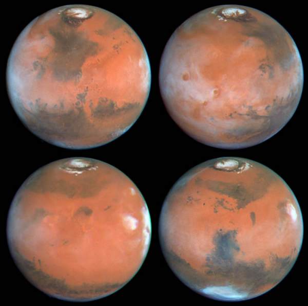
Northern Summer .
Phil James (Univ. Toledo), and NASA. Four faces of Mars as seen on March 30, 1997 are presented in this montage of NASA Hubble Space Telescope images. Proceeding in the order upper-left, upper-right, lower-left, lower-right, Mars has rotated about ninety degrees between each successive time step. For example the Tharsis volcanoes, which are seen (between 7:30 and 9 o'clock positions) in mid-morning in the upper-left view, are seen near the late afternoon edge of the planet (about 3 o'clock position) in the lower-left image. All of these color images are composed of individual red (673 nanometers), green (502 nm), and blue (410 nm) Planetary Camera exposures. Upper left: This view is centered on Ares Valles, where Pathfinder will land on July 4, 1997; the Valles Marineris canyon system stretches to the west across the lower left portion of the planet, while the bright, orangish desert of Arabia Planitia is to the east. The bright polar water-ice cap, surrounded by a dark ring of sand dunes, is obvious in the north; since it is northern summer and the pole is tilted toward us, the residual north polar cap is seen in its entirety in all four images. Acidalia Planitia, the prominent dark area fanning southward from the polar region, is thought to have a surface covered with dark sand. Numerous "dark wind streaks" are visible to the south of Acidalia, resulting from wind-blown sand streaming out of the interiors of craters. Upper right: The Tharsis volcanos and associated clouds are prominent in the western half of this view. Olympus Mons, spanning 340 miles (550 km) across its base and reaching an elevation of 16 miles (25 km), extends through the cloud deck near the western limb, while (from the south) Arsia Mons, Pavonis Mons, and Ascraeus Mons are to the west of center. Valles Marineris stretches to the east, and the Pathfinder landing site is shrouded in clouds near the afternoon limb. Lower left: This relatively featureless sector of Mars stretches from the Elysium volcanic region in the west to the Tharsis volcanoes (shrouded by the bright clouds near the afternoon limb) in the east. The group of three dark specks just left of center are all that remain of Cerberus, a very prominent dark region during the Viking and Mariner 9 missions. This is an example of the remarkable large scale changes which can occur on Mars due to windblown dust: the former dark area has now been covered by a layer of bright dust, masking the underlying material. Lower right: The dark Syrtis Major region dominates this image. Syrtis Major is one of the most prominent dark features on Mars, and has been visible since ground-based observers first peered at Mars through telescopes. The bright cloud at 3 o'clock is associated with Elysium Mons. The bright bluish-white feature near the southern limb of the planet is Hellas, a 1,200 mile (2,000 km)diameter impact basin formed by the collision of a large body with Mars long ago. Hellas is covered with dry ice frost and clouds during this season (winter in the south). Source - Cosmic Light |
||||
|
More Clouds on Mars Mars Pathfinder Sol 16 .
Source: NASA Mars Pathfinder |
||||
|
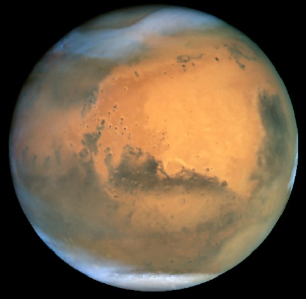
Mars at Opposition, 2001 Frosty White Clouds and Dust Storms .
Acknowledgment: J. Bell (Cornell U.), P. James (U. Toledo), M. Wolff (Space Science Institute), A. Lubenow (STScI), J. Neubert (MIT/Cornell) Frosty white water ice clouds and swirling orange dust storms above a vivid rusty landscape reveal Mars as a dynamic planet in this sharpest view ever obtained by an Earth-based telescope. NASA's Earth-orbiting Hubble Space Telescope took the picture on June 26, 2001, when Mars was approximately 43 million miles (68 million km) from Earth -- the closest Mars has ever been to Earth since 1988. Hubble can see details as small as 10 miles (16 km) across. The colors have been carefully balanced to give a realistic view of Mars' hues as they might appear through a telescope. Especially striking is the large amount of seasonal dust storm activity seen in this image. One large storm system is churning high above the northern polar cap [top of image], and a smaller dust storm cloud can be seen nearby. Another large dust storm is spilling out of the giant Hellas impact basin in the Southern Hemisphere [lower right]. Hubble has observed Mars before, but never in such detail. The biennial close approaches of Mars and Earth are not all the same. Mars' orbit around the Sun is markedly elliptical; the close approaches to Earth can range from 35 million to 63 million miles. Astronomers are interested in studying the changeable surface and weather conditions on Mars, in part, to help plan for a pair of NASA missions to land rovers on the planet's surface in 2004. The Mars opposition of 2001 serves as a prelude for 2003 when Mars and Earth will come within 35 million miles of each other, the closest since 1924 and not to be matched until 2287. Source - Cosmic Light |
||||
|
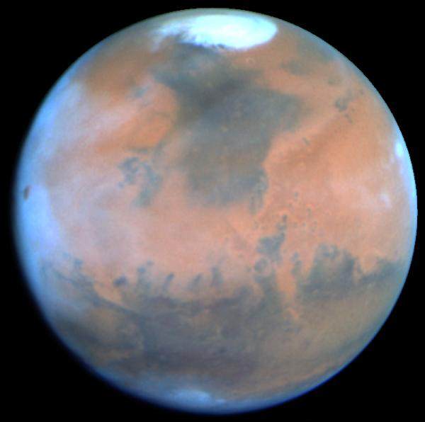
Springtime on Mars .
This NASA Hubble Space Telescope view of the planet Mars is the clearest picture ever taken from Earth, surpassed only by close-up shots sent back by visiting space probes. The picture was taken on February 25, 1995, when Mars was at a distance of approximately 65 million miles (103 million km) from Earth. Because it is spring in Mars' northern hemisphere, much of the carbon dioxide frost around the permanent water-ice cap has sublimated, and the cap has receded to a core of solid water-ice several hundred miles across. Towering 16 miles (25 km) above the surrounding plains, volcano Ascraeus Mons pokes above the cloud deck near the western or limb. This extinct volcano, measuring 250 miles (402 km) across, was discovered in the early 1970s by Mariner 9 spacecraft. Other key geologic features include (lower left) the Valles Marineris, an immense rift valley the length of the continental United States. Near the center of the disk lies the Chryse basin made up of cratered and chaotic terrain. The oval-looking Argyre impact basin (bottom), appears white due to clouds or frost. Seasonal winds carry dust to form striking linear features reminiscent of the legendary martian "canals." Many of these "wind streaks" emanate from the bowl of these craters where dark coarse sand is swept out by winds. Hubble resolves several dozen impact craters down to 30-mile diameter. The dark areas, once misinterpreted as regions of vegetation by several early Mars watchers, are really areas of coarse sand that is less reflective than the finer, lighter dust. Seasonal changes in the surface appearance occur as winds move the dust and sand around. This picture was taken with Hubble's Wide Field Planetary Camera 2 in PC mode. Exposures were taken through three different color filters to create this true color image. The pictures were map-projected onto a sphere for accurate registration and perspective. Source - Cosmic Light |
||||
|
.
|
||||
| FAIR USE NOTICE: This page contains copyrighted material the use of which has not been specifically authorized by the copyright owner. Pegasus Research Consortium distributes this material without profit to those who have expressed a prior interest in receiving the included information for research and educational purposes. We believe this constitutes a fair use of any such copyrighted material as provided for in 17 U.S.C § 107. If you wish to use copyrighted material from this site for purposes of your own that go beyond fair use, you must obtain permission from the copyright owner. | ||||
|
|


