|
The Enigmas on Mars |
|
|
Is There Liquid Water on Mars? Part Five .
The Blue Bird Files
|
|
|
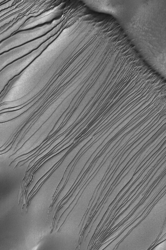
Ridges as Evidence of Fluid Alteration . Tectonic fractures within the Candor Chasma region of Valles Marineris, Mars, retain ridge-like shapes as the surrounding bedrock erodes away. This points to past episodes of fluid alteration along the fractures and reveals clues into past fluid flow and geochemical conditions below the surface. The High Resolution Imaging Science Experiment camera on NASA's Mars Reconnaissance Orbiter took this image on Dec. 2, 2006. The image is approximately 1 kilometer (0.6 mile) across. Illumination from the upper left. This view is a portion of the camera's image catalogued as PSP_001641_1735. NASA's Jet Propulsion Laboratory, a division of the California Institute of Technology in Pasadena, manages the Mars Reconnaissance Orbiter for NASA's Science Mission Directorate, Washington. Lockheed Martin Space Systems, Denver, is the prime contractor for the project and built the spacecraft. The High Resolution Imaging Science Experiment is operated by the University of Arizona, Tucson, and the instrument was built by Ball Aerospace and Technology Corp., Boulder, Colo. Find this article at:
NASA Mars Orbiter Sees Effects of Ancient Underground Fluids February 15, 2007 SAN FRANCISCO - Liquid or gas flowed through cracks penetrating underground rock on ancient Mars, according to a report based on some of the first observations by NASA's Mars Reconnaissance Orbiter. These fluids may have produced conditions to support possible habitats for microbial life. These ancient patterns were revealed when the most powerful telescopic camera ever sent to Mars began examining the planet last year. The camera showed features as small as approximately 3 feet (one meter) across. Mineralization took place deep underground, along faults and fractures. These mineral deposits became visible after overlying layers were eroded away throughout millions of years. Dr. Chris Okubo, a geologist at the University of Arizona, Tucson, discovered the patterns in an image of exposed layers in a Martian canyon named Candor Chasma. The image was taken in September 2006 by the High Resolution Imaging Science Experiment camera aboard the orbiter. "What caught my eye was the bleaching or lack of dark material along the fracture. That is a sign of mineral alteration by fluids that moved through those joints," said Okubo. "It reminded me of something I had seen during field studies in Utah, that is light-tone zones, or 'haloes,' on either side of cracks through darker sandstone." Dr. Alfred McEwen, the camera's principal investigator from the University of Arizona, Tucson, said, "This result shows how orbital observations can identify features of particular interest for future exploration on the surface or in the subsurface or by sample return. The alteration along fractures, concentrated by the underground fluids, marks locations where we can expect to find key information about chemical and perhaps biologic processes in a subsurface environment that may have been habitable." The haloes visible along fractures seen in the Candor Chasma image appear to be slightly raised relative to surrounding, darker rock. This is evidence that the circulating fluids hardened the lining of the fractures, as well as bleaching it. The harder material would not erode away as quickly as softer material farther from the fractures. The most likely origin for these features is that minerals that were dissolved in water came out of solution and became part of the rock material lining the fractures. Another possibility is that the circulating fluid was a gas, which may or may not have included water vapor in its composition, Okubo said. Similar haloes adjacent to fractures show up in images that the high-resolution camera took of other places on Mars after the initial Candor Chasma image. "We are excited to be seeing geological features too small to have been noticed previously," Okubo said. "This publication is just the first of many, many to come. The analysis is based on test observations taken even before the start of our main science phase. Since then, Mars Reconnaissance Orbiter has returned several terabits of science data, sustaining a pace greater than any other deep space mission. This flood of data will require years of study to exploit their full value, forever increasing our understanding of Mars and its history of climate change," said Dr. Richard Zurek, project scientist for Mars Reconnaissance Orbiter at NASA's Jet Propulsion Laboratory, Pasadena, Calif. Okubo and McEwen report the findings in the Feb. 16 edition of the journal Science. Images showing the haloes along fractures are available at http://www.nasa.gov/mission_pages/MRO/news/20070215.html. JPL, a division of the California Institute of Technology, manages the mission for NASA's Science Mission Directorate, Washington. Lockheed Martin Space Systems, Denver, is the prime contractor for the project and built the spacecraft. The University of Arizona operates the High Resolution Imaging Science Experiment camera. Ball Aerospace and Technology Corp., Boulder, Colo., built the camera. SOURCE: NASA News Release 02.15.07 |
|
| Gearing Up
to Harvest Mars'
Water Resource
By Leonard
David; Senior Space
Writer
Excerpt The surprising signal from Mars Odyssey is that oceans of ice lie in wait just under the surface of the Red Planet. Scientists have found Martian terrain that is hydrogen-rich, an indicator of water ice. The most abundant reservoirs of that near-surface water stretch from the planet's poles to within about 50 degrees of the equator. The amount of hydrogen detected is huge. So much so that one brimming bucket of ice-rich polar soil, when heated, can yield more than half a bucket of water. That's big news for Mars water reclamation experts. As a watering hole to sustain an expeditionary crew, Mars must now be approached with an eye on how to tap into the invaluable resource. Scientists and engineers have begun charting how this watery commodity can nourish the human drive to distant Mars. Source: Space.com (On File) |
|
|
MGS MOC Release No. MOC2-343, 27 April 2003 .
|
|
| NASA Says Up
To Half Of Mars
May Be Covered In Ice;
August Mission Will Drill For Proof May 2, 2007 10:18 p.m. EST Matthew Borghese - AHN Staff Writer Washington, D.C. (AHN) - The scientists behind the Phoenix Mars Mission say that up to half of the Red Planet may be covered in ice. A joint project with NASA, the University of Arizona's Lunar and Planetary Laboratory, the Jet Propulsion Laboratory (JPL), and Lockheed Martin Space Systems (LMSS), experts say that when the Phoenix lander hits Mars, it will be carrying far more sophisticated equipment to give a definitive answer as to the presence of ice water on the planet. According to the University, "Unlike the [previous NASA] rovers, which were hunting for evidence of water at points along the Martian surface, the Phoenix lander knows exactly where to go to find water. To reach it, however, the spacecraft must dig down below the surface. The Phoenix lander is going to an area of Mars where water is believed to exist in the form of ice just below the surface." The Phoenix mission "hopes to be the first mission to 'touch' and examine water on Mars; ultimately, to pave the way for future robotic missions, and possibly, human exploration." The mission launches this August, and will obviously get a much closer look at Mars than the orbiting Mars Odyssey spacecraft. According to experts, there may be so much water trapped as ice on Mars, that if it were to melt, it would cover the entire planet in one global ocean. |
|
|
.
|
|
| FAIR USE NOTICE: This page contains copyrighted material the use of which has not been specifically authorized by the copyright owner. Pegasus Research Consortium distributes this material without profit to those who have expressed a prior interest in receiving the included information for research and educational purposes. We believe this constitutes a fair use of any such copyrighted material as provided for in 17 U.S.C § 107. If you wish to use copyrighted material from this site for purposes of your own that go beyond fair use, you must obtain permission from the copyright owner. | |
|
|


