|
The Enigmas on Earth Impact Craters on Earth |
||||
|
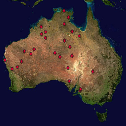
Australia .
Earth Impact Database - The biggest collection of Earth Impact Craters by the University of New Brunswick, Canada Visit Also: |
||||
|
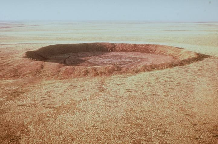
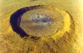
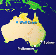
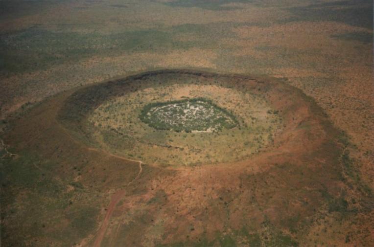
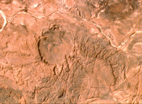
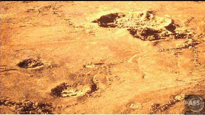
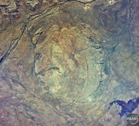
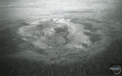
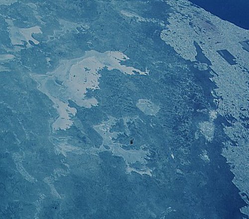
Wolf Creek Crater Western Australia .
The location of
this crater is 19°10'S, 127°46'E. The rim diameter
is 800 m and the distance from the rim crest to the
present crater floor is 60 m. The age approximately
10,000-20,000 years. This is another example of a
small simple crater. Meteorite fragments have been
recovered from the crater floor, attesting to its
origin. - Source
Lying on the edge of the Great Sandy Desert in the East Kimberley this meteorite crater is the second largest crater in the world. Aboriginal Dreaming tells of two rainbow snakes who formed the nearby Sturt and Wolfe Creeks as they crossed the desert. The crater is believed to be the place where one snake emerged from the ground. The crater is 880 meters across and
almost circular. Today, the floor is about 60 meters
below the rim and is generally flat but rises
slightly in the center. - Source
Wolfe Creek is a meteorite impact crater (astrobleme) in Western Australia. It is accessed via the Tanami Road 105 km south of the town of Halls Creek. The crater is central to the Wolfe Creek Meteorite Crater National Park. The crater averages about 875 meters in diameter, 60 meters from rim to present crater floor and it is estimated that the meteorite that formed it had a mass of about 50,000 kg, while the age is estimated to be less than 300,000 years (Pleistocene). The local Djaru (Jaru) Aboriginal
people know it as Kandimalal. It was brought to the
attention of science after being spotted during an
aerial survey in 1947, investigated on the ground
two months later, and reported in publication in
1949. The European name for the crater comes from a
nearby creek, which was in turn named after Robert
Wolfe (early reports misspell the name as Wolf
Creek), a prospector and storekeeper during the gold
rush that established the town of Halls Creek. - Source: Wikipedia
|
||||
|
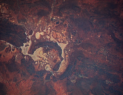
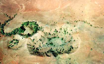
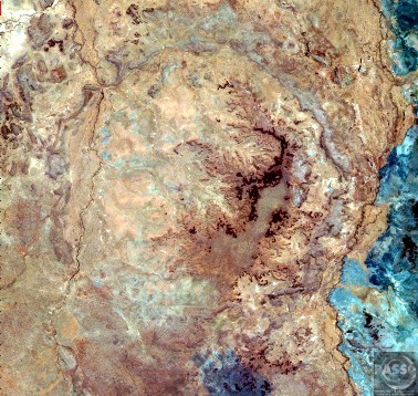
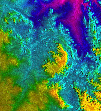
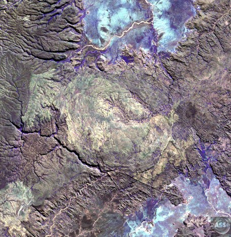
Gosses Bluff Crater Northern Territory, Australia .
142 million years ago, an asteroid or comet slammed into what is now the Missionary Plains in Australia's Northern Territory, forming a crater 24 kilometers in diameter and 5 kilometers deep. Today, like a bull's eye, the circular ring of hills that defines Gosses Bluff stands as a stark reminder of the event. The crater is located just south of MacDonnel Ranges (top of the picture). It is highly eroded. The circular ring of hills (5 kilometers or 3 miles diameter) is actually the results from differential erosion of the central uplift within this large complex crater. The crater rim is eroded to the point that it is no longer visible though it is probably located along the grayish colored drainage system outside the inner ring. (Courtesy USGS) |
||||
|
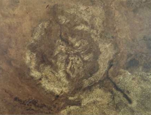
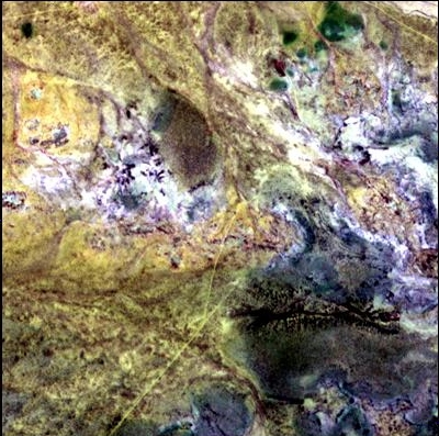
Amelia Creek Crater Northern Territory, Australia Amelia Creek crater is an impact structure (or astrobleme), the eroded remnant of a former impact crater, located in the Northern Territory, Australia. It is situated within a low range of Palaeoproterozoic sedimentary and volcanic rocks, which are extensively folded and faulted, thus making an eroded impact crater difficult to recognize. It was only discovered by the identification of shatter cones near its center. The central shatter cone locality is surrounded by a 20 x 12 km area of anomalous deformation, the asymmetry being possibly related to very oblique impact, but may be at least partly due to the pre-existing structural complexity of the rocks. This deformed zone gives the best estimate for the original size of the crater. Impact took place after folding of the Palaeoproterozoic rocks but before deposition of Neoproterozoic and Cambrian rocks which overlie them, thus constraining the impact event to the interval between about 1660 and 600 Ma. |
||||
|
Goyder Crater Northern Territory, Australia .
Goyder is an impact structure
(or astrobleme), the eroded remnant of a former
impact crater. It is situated at latitude 13° 29' S
and longitude 135° 02' E in Arnhem Land in the
Northern Territory, Australia, and was named after
the nearby Goyder River. The impact occurred into
Mesoproterozoic sedimentary rocks of the McArthur
Basin. The deformed area is exposed at the surface
and marked by a 3 km diameter ring of fractured and
faulted sandstone, which is interpreted as the
eroded relic of a central uplift (material that
rebounded within the crater to once form a central
peak); the original crater rim, long since removed
by erosion, being estimated at approximately 9–12 km
diameter. Evidence for an impact origin includes the
presence of shatter cones and shocked quartz in
outcrops of deformed sandstone at the center of the
site. The time of impact cannot be accurately
constrained, however, it probably happened more
recently than 1325 Ma (middle Mesoproterozoic),
which is the age of igneous rocks that are inferred
to have been uplifted by the impact based on
aeromagnetic evidence, and significantly older than
Cretaceous. The site is very remote and difficult to
access. - Wikipedia
|
||||
|
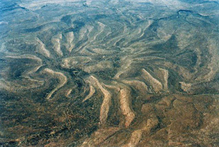
Spider Crater Western Australia .
Spider is an impact structure
(or astrobleme), the deeply eroded remnant of a
former impact crater, situated in the Kimberley
Region of northern Western Australia, 18 km east of
the Mount Barnett Roadhouse on the Gibb River Road.
Due to very rugged terrain the site is effectively
inaccessible. The name is derived from the visually
striking spider like radiating ridges of quartzite
prominently visible from the air or on satellite
images.
The unusual geological structure has been a puzzle since the 1950s, but it was not until shatter cones were discovered it the center in the late 1970s that it was realized that it was an eroded impact structure. The central area bearing shatter cones is interpreted as the relic of a central uplift with the outer limits of disturbance confined to a sub circular area about 11 x 13 km in diameter; the original crater may have been slightly greater than this due to the depth of erosion. The asymmetry of the structure lead some geologists to conclude that the projectile had a very low angle trajectory from the north or northwest, while others suggest that the asymmetry may be at least partly due to the effect of pre-existing topography. The age of the Spider impact event is not accurately constrained, but it has been argued it occurred after gentle folding of the Palaeoproterozoic quartzite, but before a regional episode of glacial erosion; if correct it occurred between 900-600 Ma i.e. during the Neoproterozoic. - Wikipedia |
||||
|
Goat Paddock Crater Western Australia .
This image, taken
by the shuttle Large Format Camera, shows the Goat
Paddock Crater, which is located within the
semi-arid plains south of the Kimberley Plateau of
northwestern Australia. The crater is expressed as a
nearly circular depression open to the north. Its
name is derived from its natural use as a paddock (a
fenced pasture) for livestock. Goat Paddock's
diameter is very close to the transition diameter
from simple bowl shaped craters to more complex
forms with central structures, flat floors, and
slumped rim zones. Unfortunately, very little is
currently known about this potentially insightful
feature.
Space shuttle image STS17-4107-1228. Location: 18°20'S, 126°40'E
|
||||
|
Shoemaker (formerly Teague) Western Australia .
The Shoemaker
impact structure lies in the arid, central part of
Western Australia near Wiluna. The crater is about
30 kilometers (18 miles) in diameter and contains
seasonal lakes that produce salt deposits as they
evaporate. It is approximately 1.7 billion years old
and is regarded as the oldest known Australian
impact structure to date. A dark, crescent shaped
inner ring surrounds the core, which consists of
uplifted granitic rocks. The outer ring is composed
of Precambrian sedimentary rocks. The crater,
formerly known as Teague, was renamed the Shoemaker
impact structure in honor of the late geologist
Eugene M. Shoemaker, one of the founding fathers of
impact research. - SOURCE
USGS
Landsat
|
||||
|
Henbury Crater Northern Territory, Australia .
Henbury is a group
of 12-14 meteor craters in Northern Territory,
Australia. The largest is 157 meters in diameter and
the age is estimated to be 4200 ± 1900 years
(Holocene).
In local the aboriginal language, the name of the craters translates as sun walk fire devil rock, which implies that people witnessed their formation. The pattern of the craters suggests that they were formed by an object which broke up shortly before impact. Because the craters capture occasional rainfall, they are important as a water source in that part of the outback.
|
||||
|
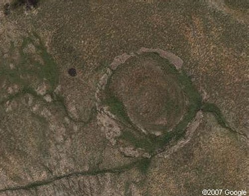
Boxhole Crater Northern Territory, Australia .
Boxhole is a young impact crater in Northern Territory, Australia. It is 170 meters in diameter and its age is estimated to be 54,000 ± 1,500 years, placing it near the end of the Pleistocene. The crater is exposed to the surface.
|
||||
|
Foelsche Crater Northern Territory, Australia .
Foelsche is a partly buried impact structure (or astrobleme), the eroded remnant of a former impact crater. It is situated at latitude 16° 40' S and longitude 136° 47' E in the Northern Territory, Australia, and named after the nearby Foelsche River. Although little of it is exposed at the surface, and no crater shaped topography is evident, the circular nature of the feature is obvious on aeromagnetic images, a factor that led to its discovery. The impact occurred into flat lying Mesoproterozoic sedimentary rocks of the McArthur Basin and most of the crater is covered by a semi-circular hill of flat lying Neoproterozoic sedimentary rock. The only exposure of the crater itself are scattered outcrops of deformed sandstone and breccia around the northern edge of the overlying hill, which are inferred to be remnants of the crater rim. The rim is about 6 km in diameter. Evidence indicating an impact origin for the feature includes an abundance of shocked quartz grains in the sedimentary rocks overlying the crater; these are assumed to have been eroded from the floor of the crater. The prominent circular aeromagnetic anomaly which marks the hidden crater is believed to have been caused by the disruption of a horizontal layer of magnetic rock (igneous sill) by the impact event. The age of Foelsche is not well constrained, but it must be younger than the Mesoproterozoic target rocks and older than the Neoproterozoic rocks that partly fill the crater; it has been argued that the age is most likely Neoproterozoic because it appears that the crater was covered by sediments soon after the impact event. - Source: Wikipedia |
||||
|
Kelly West Crater Northern Territory, Australia .
Kelly West is a deeply eroded impact crater, (impact structure or astrobleme), situated in the central Northern Territory, Australia. It was discovered during Government geological mapping and first reported in 1973, the evidence for impact coming principally from an abundance of shatter cones at the site. The surface expression of Kelly West comprises a circular hill of Palaeoproterozoic quartzite about 2 km in diameter, interpreted as a central uplift of a larger complex impact crater. Recent geophysical interpretation suggests an original crater diameter of 6.6 km, less than earlier estimates of about 10 km. The age is poorly constrained, but must be older than Middle Cambrian because sedimentary rocks of this age overlie the central uplift and were not deformed by the impact event. - Source: Wikipedia |
||||
|
Liverpool Crater Northern Territory, Australia .
Liverpool is a
meteorite impact crater situated in Arnhem Land
within the Northern Territory, Australia. It was
named after the nearby Liverpool River. The site is
remote and difficult to access. The crater has a
raised near circular rim averaging about 1.6 km in
diameter. It was first noticed by geologists during
reconnaissance geological mapping in the 1960s, and
although an impact origin was considered possible,
this was not confirmed until a more detailed study
was undertaken in 1970.
The crater lies within flat lying Palaeoproterozoic sandstone of the McArthur Basin. This sandstone has been fractured and brecciated by the impact event to form the rim. Flat lying and non deformed sandstone that must have been deposited after the impact event is exposed within the center of the crater. Because the crater is quite well preserved, it can be argued that it was buried by younger sedimentary rock soon after the impact event; this younger rock has now been mostly eroded away except in the crater center. The crater filling sandstone was originally thought to be of Cretaceous age, leading to the Cretaceous age listed for the crater in older literature sources. However, more recent studies suggest that the infilling rock is more likely to be of Neoproterozoic age (1000-543 Ma) and therefore the crater is more likely to have formed at some time during the Neoproterozoic. No meteorite fragments have been found at the site. This is not surprising considering its great age; such fragments would have weathered away. Evidence supporting an impact origin includes the geological structure of the crater, and the discovery of shocked quartz. The crater is not perfectly circular, but is about 6% broader in a northeast/southwest direction and the internal parts of the crater are also asymmetric is such a way as to imply that the impact was oblique from the southwest. - Source Wikipedia |
||||
|
Strangways Crater Northern Territory, Australia .
Strangways is a
large impact structure (or astrobleme), the eroded
remnant of a former impact crater, situated in the
Northern Territory, Australia. It was named after
the nearby Strangways River. The location is remote
and difficult to access.
The circular
topographic feature that marks the site was
originally thought to be volcanic, with an impact
origin first proposed in 1971 after the discovery of
evidence diagnostic of impact including shatter
cones and shocked quartz. The circular topographic
feature is about 16 km in diameter and lies within
Mesoproterozoic sedimentary rocks of the McArthur
Basin. However, this is only a relic of the original
crater after considerable erosion. Estimates of the
original rim diameter vary between different
researchers in the range 24–40 km; the Earth Impact
Database prefers a diameter of 25 km. The age of the
impact event has been determined at 646 ± 42 Ma
(Neoproterozoic) based on radiometric dating of
impact melt rocks. - Source
Wikipedia
|
||||
|
Lawn Hill Crater Queensland, Australia .
Lawn Hill ‘crater’
refers to an impact structure (or astrobleme), the
eroded remnant of a former impact crater, situated
in northwestern Queensland, Australia. The site is
marked by an 18 km diameter ring of limestone hills.
The origin of this circular feature was uncertain
until the discovery of shatter cones and shocked
quartz from uplifted rocks at the center was
reported in 1987.
The site is heavily eroded and it has been suggested that the original crater was slightly larger, at around 20 km diameter. The age of the impact structure is somewhat contentious, in the absence of any radiometric dating. The impact shocked rocks at the center of the site are early Mesoproterozoic in age, which gives an absolute maximum possible age for the impact. In the past it has been debated whether the limestones, which are of Middle Cambrian age (ca. 510 Ma) based on comparisons with nearby outcrops of marine limestone in the Georgina Basin, were simply deposited in the crater after it's formation, or were actually deformed by the impact event. Depending on the differing points of view, the crater may be of earlier Cambrian or Proterozoic age, or it could be of younger Paleozoic age. The most recent study concludes that the impact most likely happened just before or even during the early stages of deposition of the limestone, suggesting an age of around 509–506 Ma (Middle Cambrian). Based on the theory
that the crater was invaded by the sea just after
the impact, the crater may have formed a unique
protected micro environment for primitive life, and
could be an important analogue to craters filled
with sediment in a similar way on Mars. |
||||
|
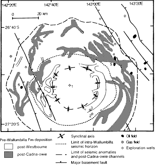
Tookoonooka Crater Queensland, Australia .
The Tookoonooka
crater in south central Queensland is about 55 km in
diameter. It was discovered in the early 1980s when
petroleum exploration revealed an anomalous circular
structure. Tookoonooka has a central uplift dome
that is 22 km in diameter.
Impact melt breccias have been found about 25 km southeast of the central uplift structure, and have also been found filling the annular structure around the central uplift. The pyroclasts consist of impact breccia fragments, as well as vitrified impact melt glass. Breccia samples have also been found during drilling into the central uplift dome; these breccias have a vitrified glassy matrix, with angular pyroclasts. Tookoonooka has been dated to around 128 MYA, based on studies of local pollen sequences. At this time a large inland sea covered much of Queensland, suggesting this impact landed somewhere off-shore. No dinosaur remains are known from Queensland from around this time, so the effect of the impact on local species is uncertain. Most Queensland species date to 110 MYA or later, with the sauropod Rhoetosaurus living 40-50 million years before the impact. It may have had more of an effect on marine species, however most Queensland marine reptiles are also only known from 110 MYA or later. Without a good sample of species from immediately before the impact, it is impossible to say whether the Tookoonooka impact caused an extinction event. Extinction event or not, an impact of this size would still have done a lot of damage to the local area. - SOURCE |
||||
|
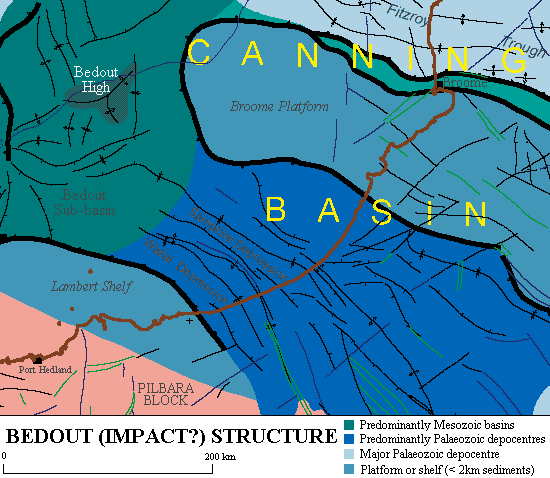
Bedout Impact Structure Canning Basin off the coast of Western Australia .
The Bedout
structure 300 km west of Broome, in the Canning
Basin off the coast of Western Australia, has been
sited as one of the possible impacts that
contributed to one of the greatest extinction events
known. At the end of the Permian Period, around 250
MYA, it has been estimated that more than 90% of
marine species, and 70% of terrestrial species, may
have become extinct. The extinction event seems to
have been a sudden, global occurrence, lasting less
than a million years (which in geological terms is
very rapid).
The Bedout structure
(pronounced "Bedoo") has central uplift of
around 100km in diameter, with a transient crater
size of around 100km diameter. The original crater
probably measured around 200 km in diameter in
total, comparable to the Chicxulub crater in Mexico
which may have contributed to the extinction of (non
avian) dinosaurs at the end of the Cretaceous
Period. - SOURCE
Impact At Bedout 'Smoking Gun' Of Giant Collision That Nearly Ended Life On Earth Is Identified Science Daily website, 14th May 2004 Bedout: an end Permian impact crater
offshore northwestern Australia Bedout: A Possible End Permian
Impact Crater Offshore Northwestern Australia
|
||||
|
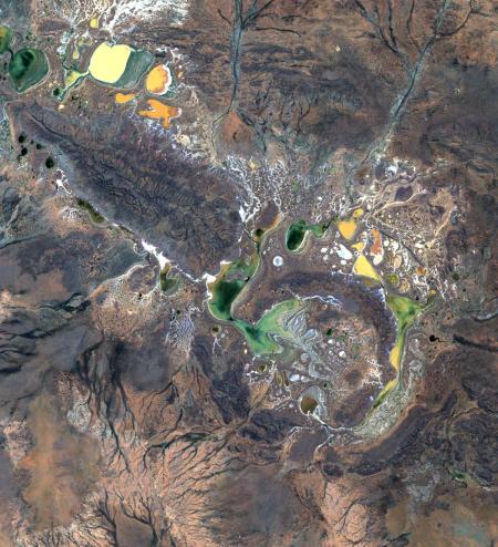
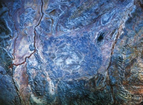
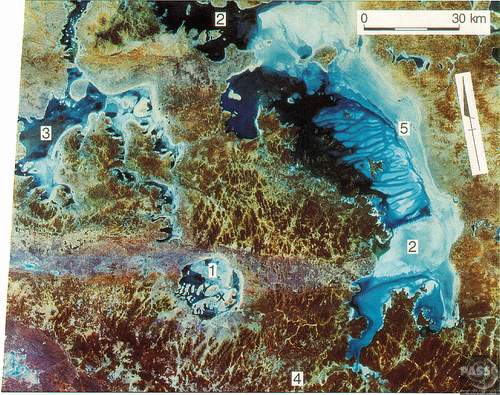
Acraman Crater South Australia .
Acraman crater is
an impact crater in South Australia, Australia.
Formed by a large bolide impact, the crater is 90 km
in diameter and struck an estimated 590 million
years ago during the Ediacaran period.
Landsat
scene covering most of the Acraman impact structure
in the Mesoproterozoic Gawler Range Volcanic,
showing: 1, Lake Acraman within the Acraman
depression; 2, Lake Gairdner; 3, Lake Everard; 4,
the Yardea corridor at 85-90 km diameter. Surface
water (darker blue) in Lake Gairdner helps define an
accurate trend (5) at ~150 km diameter that
continues westward to Lake Everard. X marks the
location of a central dipolar magnetic anomaly in
the southeastern part of Lake Acraman. Landsat scene
15 February 1973, scene center S31-30 E135-51. From
Williams, Schmidt and Boyd (1996). - SOURCE
|
||||
|
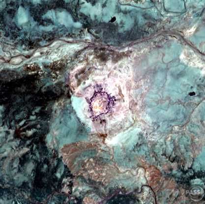
Mount Toondina Crater South Australia .
Mount Toondina
crater is an impact structure (or astrobleme), the
eroded remnant of a former impact crater, situated
in northern South Australia 45 km south of the
township of Oodnadatta. Mount Toondina is the high
point of a circular topographic feature rising out
of an otherwise relatively flat desert area of the
Eromanga Basin. An impact origin was first suggested
in 1976, challenging the earlier diapir (salt dome)
hypothesis, and strongly supported by subsequent
studies. A geophysical survey using gravity methods
indicates an internal structure typical of complex
impact craters, including an uplifted center, and
suggests that the original crater was about 3–4 km
in diameter. The crater must be younger that the
Early Cretaceous age of the rocks in which it is
situated, but otherwise is not well dated. It has
clearly undergone significant erosion since the
impact event. - Source:
Wikipedia
|
||||
|
Crawford Crater South Australia Crawford is an impact crater near Adelaide in South Australia, Australia. It is 8.5 km in diameter and the age is estimated to be greater than 35 million years (probably Eocene). The crater is exposed to the surface. No other data available at this time... |
||||
|
Flaxman Crater South Australia Flaxman is a meteor crater in South Australia, Australia. It is 10 km in diameter and the age is estimated to be greater than 35 million years (probably Eocene). The crater is exposed to the surface. No other data available at this time... |
||||
|
Connolly Basin Crater Western Australia .
Connolly Basin is
a 9 km diameter circular depression interpreted as
an eroded meteorite impact crater, located in the
Gibson Desert of central Western Australia. It lies
adjacent to the Talawana Track 45 km west of the
junction (Windy Corner) with the Gary Highway, but
is difficult to access due to the remoteness of the
area. Originally thought to be a diapir (salt dome),
an impact origin was first proposed in 1985.
The depression has a topographic rim 25–30 m high, while the center displays a slight circular rise about 1 km in diameter and 5 m high exposing strongly deformed and steeply dipping bedrock interpreted as a central uplift. Sedimentary rocks comprising the rim are of Early Cretaceous to Paleocene age, while uplifted rocks in the center are likely of Early Permian age, all part of the Canning Basin; the impact event itself is inferred to be of Paleocene (early Tertiary) age. |
||||
|
Dalgaranga Crater Western Australia .
Dalgaranga crater
is a small meteorite impact crater located on
Dalgaranga pastoral station 75 km west of Mount
Magnet in Western Australia. It is only 24 m in
diameter and 3 m deep, making it Australia's
smallest impact crater (with exception of the
smallest members of the Henbury crater field).
Though reputedly discovered much earlier, it was
first reported in the scientific literature in 1938.
The bedrock at the site is weathered Archaean
granite of the Yilgarn Craton. The discovery of
fragments of mesosiderite stony iron meteorite
around the crater confirms an impact origin, making
this crater unique as the only one known to have
been produced by a mesosiderite projectile.
Asymmetries in the crater structure and the ejecta
blanket imply that the projectile impacted at low
angle from the south/southeast. The age is not
accurately constrained by must be young because it
is so well preserved for its small size, and the
meteorite fragments have not weathered away; some
authors suggest an age of as young as 3000 years. -
Source:
Wikipedia
|
||||
|
Glickson Crater Western Australia .Glikson crater is an impact structure (or astrobleme), the eroded remnant of a former impact crater, situated in the Little Sandy Desert of central Western Australia. A possible impact structure was first reported in 1997, and named after Australian geologist A. Y. Glikson, attention to the site being drawn by the presence of a prominent 14 km diameter ring shaped aeromagnetic anomaly. The area within the ring contains sparse outcrop of uplifted and deformed Neoproterozoic sandstone, but is largely covered by sand dunes. The recent discovery of shatter cones and microscopic shock effects is reliable evidence for an impact origin. Deformation of the sandstone consistent with an impact origin extends out to a diameter of 19 km, which is the best estimate for the original diameter of the original crater. The ring shaped aeromagnetic anomaly was probably caused by disruption of a horizontal layer of magnetic igneous rock, known as a sill, by the impact event. Nearby outcrops of dolerite have been dated at 508 ± 5 Ma (Middle Cambrian), and if this is the same rock causing the aeromagnetic anomaly, then the impact must be younger, probably of Paleozoic age. - Source: Wikipedia |
||||
|
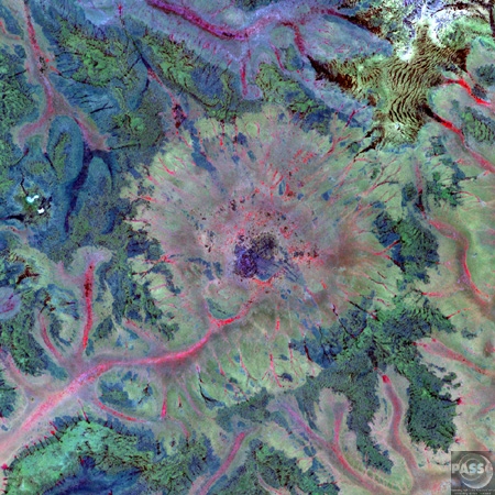
Piccaninny Crater Western Australia .
Piccaninny
"crater" refers to an impact structure (or
astrobleme), the eroded remnant of a former impact
crater, situated in northern Western Australia. In
was named after Piccaninny Creek and lies within the
Purnululu (Bungle Bungle) National Park.
The site is marked by a circular topographic feature on top of the flat topped sandstone and conglomerate Bungle Bungle Range, clearly visible on remotely sensed images (Google Maps image). When first reported in 1983 after aerial observation, it was interpreted as either an impact structure or a crypto volcanic feature. Later ground examination by E.M. and C.S. Shoemaker confirmed the presence of types of deformation indicative of an impact origin. The circular topographic feature is 7 km in diameter, although due to the amount of erosion the original crater may have been larger. It has been estimated that the present land surface is 1–2 km below the original crater floor. The impact event has not been dated, but must be younger that the Devonian age of the rocks in the area, but is clearly not recent because of the amount of erosion. - Source: Wikipedia |
||||
|
Veevers Crater Western Australia .
Veevers crater is
a meteorite impact crater located at latitude 22°
58' 06" S and longitude 125° 22' 07" E on a flat
desert plain between the Great Sandy and Gibson
Deserts in the center of the state of Western
Australia, Australia. The site is very remote and
difficult to visit. The crater was discovered in
July 1975 during a government geological survey and
named in honor of Australian geologist J.J. Veevers
who had worked in the area in the late 1950s. At the
time of discovery a meteorite impact origin was
suspected, but could not be proven. The subsequent
discovery of iron meteorite fragments around the
crater by E.M. and C.S. Shoemaker in 1984 removed
any doubt about its origin.
The crater has a symmetrical bowl shaped topography and is considered to be one of the best preserved small meteorite craters on Earth. The 20 m wide rim rises about 1.5 m above the plain, while the deepest point of the central depression is 7 m below the rim crest; the rim to rim diameter averages about 70 m. Based on cosmogenic nuclide exposure dating of the crater walls, the crater is less than 20 thousand years old, while the pristine state of preservation of the ejecta has been used to suggest that it may in fact be less than 4 thousand years old. The iron meteorite fragments collected around the crater are classified as a coarse octahedrite belonging to chemical class IIAB; the fragments show considerable evidence of deformation presumably related to the impact explosion. It has been inferred that the original meteorite was in the size range of 100-1000 tonnes, probably closer to the latter, now dispersed as fragments within the crater filling breccia and ejecta. - Source: Wikipedia |
||||
|
Yarrabubba Crater Western Australia . Yarrabubba crater
refers to an impact structure (or astrobleme), the
eroded remnant of a former impact crater, situated
in the northern Yilgarn Craton between the towns of
Sandstone and Meekatharra, central Western
Australia.
The original crater
has been completely eroded and is not readily
visible on aerial or satellite images; the evidence
for impact comes rather from the presence of shocked
quartz and shatter cones in outcrops of granite
interpreted the be near the center of the original
crater, and from geophysical data. The diameter of
the original crater is uncertain, but has been
estimated to be in the range 30–70 km. The age of
the impact event is also uncertain, but it must be
younger than the granite that has been shocked,
which has been dated at about 2650 Ma (late
Archaean). Veins of pseudotachylite (rocks melted by
friction) in the granite have given a date of
1134±26 Ma using the Ar-Ar method, and although the
significance of this age is not fully clear it is
currently considered by some to provide the best
tentative estimate for the age. The Earth Impact
Database prefers an intermediate estimate of about
2000 Ma. |
||||
|
Woodleigh Crater Western Australia . Woodleigh is a
large meteorite crater in Western Australia,
centered on Woodleigh Station east of Shark Bay. A
team of four scientists at the Geological Survey of
Western Australia and the Australian National
University, led by Arthur J. Mory, announced the
discovery in the April 15, 2000 issue of Earth and
Planetary Science Letters .
The crater is not exposed at the surface and therefore its size is uncertain. The original discovery team believe it may be up to 120 kilometers in diameter , but others argue it may be much smaller, with one study suggesting a diameter closer to 60 kilometers . The larger estimate, if correct, would make this the fourth largest confirmed impact structure in the world, and imply a bolide (asteroid or comet) about 5–6 kilometers in diameter . The central uplift, interpreted to be 20 kilometers in diameter, was first intersected by drilling activities in the late 1970s; however its significance as an impact structure was only realized in 1997 during a gravity survey [3]. In 1999 a new core sample was taken. The thin veins of melted glass, breccia, and shocked quartz found would have formed under pressures 100,000 times greater than atmospheric pressure at sea level, or between 10 and 100 times greater than those generated by volcanic or earthquake activity. Only a large impact could have generated such conditions. The Woodleigh impact
event, originally thought to have occurred between
the Late Triassic and Late Permian, is now thought
to date from 364 ± 8 million years (Late Devonian)
[4]. This time corresponds approximately to a minor
extinction event when around 40% of species
disappeared. There is evidence for other large
impact events at around the same time, so if the
extinction is related to impact, perhaps more than
one crater was involved. |
||||
| FAIR USE NOTICE: This page contains copyrighted material the use of which has not been specifically authorized by the copyright owner. Pegasus Research Consortium distributes this material without profit to those who have expressed a prior interest in receiving the included information for research and educational purposes. We believe this constitutes a fair use of any such copyrighted material as provided for in 17 U.S.C § 107. If you wish to use copyrighted material from this site for purposes of your own that go beyond fair use, you must obtain permission from the copyright owner. | ||||
|
|